
-
 28411 Hits
-
 90.81% Score
-
 33 Votes
|
|
Area/Range |
|---|---|
|
|
44.14400°N / 73.987°W |
|
|
Hiking, Mountaineering |
|
|
5115 ft / 1559 m |
|
|
Overview
The MacIntyre Range is one of the Adirondack Mountain's most impressive and beautiful ranges lying just to the west of its highest peak, Mt. Marcy (5,344ft.). The king of the range is Algonquin Peak standing at 5,115ft, also the second highest peak in all the Adirondacks. and crowning a range which includes four official 4,000ft. peaks. These four peaks include
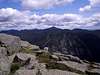
The MacIntyre Range is stunningly beautiful from almost anywhere and some of the finest views in the Adirondacks can be had from the summits and slopes of these fine peaks. Views from the summits take in most of the entire Great Range to the east. Mount Colden provides the most dramatic part of the picture in the foreground with Mt. Marcy and the other high peaks beyond. To the north you cans see the ski jumps and the town of Lake Placid and the lake from which the town takes its name. Also in the view is Whiteface Mountain. To the northeast you can see on a clear day, Lake Champlain and the peaks of Vermont's Green Mountains. Looking south and west you'll look into the heart of the Adirondack Park, encompassing over 6 million acres! One of the most stunning views of these peaks is from the Adirondack Loj road when you first turn off of Rt. 73. The view encompasses many of the high peaks and a good portion of the MacIntyre Range.
These magnificent peaks have much in the way to offer hikers and climbers alike. If not for the views, this range provides one of the tougher hiking challenges in all the Adirondacks and according to a recent discussion from the sp forum, Algonquin has been picked as the tougher peak over Mt. Marcy.
Getting There
The most direct access to the MacIntyre range is via the Adirondack Loj and Heart Lake.From New York City:
Take Interstate 87 north towards Albany. Continue north until you reach the exit north of Lake George and Schroon Lake for Keene Valley and Lake Placid. Turn left onto Route 9 for a short period before reaching the intersection with Rt. 73 where you'll want to turn left towards Keene Valley and Lake Placid. Continue on Rt. 73 through the town of Keene. You'll want to turn left onto Adirondack Loj Road just before heading into the town of Lake Placid. Follow the road back to a parking area that costs $9.00 for non-members of the Adirondack Mountain Club and $3.00 for members. The trailhead for the MacIntyres is at the southeast corner of the parking lot.
From Montreal, CN:
Head south on Interstate 87 towards Albany. Continue north until you reach the exit north of Lake George and Schroon Lake for Keene Valley and Lake Placid. Turn left onto Route 9 for a short period before reaching the intersection with Rt. 73 where you'll want to turn left towards Keene Valley and Lake Placid. Continue on Rt. 73 through the town of Keene. You'll want to turn left onto Adirondack Loj Road just before heading into the town of Lake Placid. Follow the road back to a parking area that costs $9.00 for non-members of the Adirondack Mountain Club and $3.00 for members. The trailhead for the MacIntyres is at the southeast corner of the parking lot.
 Marcy and Colden
Red Tape
The only cost for access is if you park at Adirondack Loj. Non-member price for daily parking is $9.00 and $3.00 for members. After approximately 0.7 miles into your hike from the Loj you will enter the High Peaks Wilderness area for which all National Wilderness Area regulations apply.Here is a list of rule that apply while within this area from the Adirondack Park website.
-Camping above 3,500 feet is permitted only in lean-tos or designated sites. As mentioned previously, no camping is permitted above 4,000 feet in elevation at any time of the year.

-Many lean-tos will be gradually phased out, moved, or removed. All nine lean-tos along the Cold River in the western High Peaks will be removed -upon the end of their lifespan; no further major maintenance will be performed on these shelters. The Howard lean-to near John's Brook Lodge (JBL) will be phased out (this lean-to is located in a beautiful spot next to the junction of John's Brook and Ore Bed Brook). The Deer Brook lean-to, located along the trail from Keene Valley to JBL, will be relocated, while the Bear Brook lean-to along the same trail will be phased out. Two lean-tos at Marcy Dam will be removed.
-Camping at Lake Colden, one of the most overused areas of the High Peaks due to its central location, will be limited to the four lean-to's and designated campsites only. All camping at Indian Falls, a popular spot along the trail to Marcy, is prohibited.
-Absolutely no fires are allowed in the eastern High Peaks, which includes Lake Colden. (The boundary between the eastern western High Peaks is a line running generally north-south from the near the summits of Street and Nye, over Wallface in Indian Pass, to near Lake Henderson and Upper Works.)
-Campers wishing to remain in the same spot for four consecutive nights or more must obtain a permit from the ranger. No permits will be issued for stays longer than fourteen consecutive nights. Further, no single lean-to may be occupied for more than ten nights in any calendar year.
-A new group size limit of 15 people for day hiking is in place. There previously was no limit; groups of 50 or more were not uncommon. Any group larger than 15 must split up into smaller, self-sufficient groups that satisfy the size requirement. These groups should not congregate into one large group at trail junctions, rest stops, lunch breaks, etc. However, the maximum group size of 12 people for camping was unchanged.
-The DEC will begin marking trails on the previously "trail-less" High Peaks. Trail-less is a misnomer for sure, most of these peaks had a multitude of trails running to their summits, which is what the DEC is trying to cut down on. Also, the undesired "herd paths" to these trail-less summits will be barred with brush to prevent further use.

-Registering at trailheads, previously a suggestion, is now a requirement in the eastern High Peaks.
-The most vulnerable sections of trail, generally those at high elevations, will be closed during wet seasons. At first, the public's compliance with the closures will be on a voluntary basis. If necessary, enforced mandatory closures will be enacted.
-Quiet hours will be in force from 10pm to 7am.
-Glass containers are no longer allowed anywhere in the HPW.
-Dogs and other pets must be leashed at all times.
-Cellular phone use in non-emergency situations is discouraged.
-Motorized boats, whether they be gasoline or electric motors, are prohibited on the Cold River (very little of the Cold River is navigable by canoe, let alone motorized craft, so this restriction will probably have little bearing on the lives of most people).
For all purposes in terms of preservation and conservation of the wilderness area in which you are entering, just follow the LEAVE NO TRACE program and you will be fine.
Weather
For current and up to the minute weather click on the link below.Lake Placid Regional Weather
High Peaks Wilderness
 Alpine Zone
The High Peaks Wilderness has been one of the most highly used units within Adirondack Park in the past decade as more and more outdoor enthusiasts head to the mountains. This is the largest wilderness area within Adirondack Park. This region holds within it the giants of the Adirondack Mountains giving the wilderness its name. Within the High Peaks Wilderness are both the Great Range and MacIntyre Range. The wilderness area has one of the most diverse landscapes to be found anywhere on the east coast. All in a days hike you can travel from a low land bog, lake, or meadow up to the wilderness area's highest peaks of Marcy and Algonquin which will take you above tree line into the Arctic Alpine Zone. Along the way you will travel through many different elevation zones, each supporting their own type of vegetation growth including spruce and fir stands, birch stands, and many others. For more information of the High Peaks Wilderness Area click on this link.
External Links
High Peaks Wilderness AreaAdirondack Mountain Club
adirondacks.com
Adirondacks Regional Information
Lake Placid Website