
-
 6058 Hits
-
 85.36% Score
-
 20 Votes
|
|
Route |
|---|---|
|
|
16.90016°N / 101.78686°E |
|
|
Hiking |
|
|
Spring, Fall, Winter |
|
|
Most of a day |
|
|
Class 1 |
|
|
Overview
Phu Kradueng is the most popular mountain to climb in Northeastern Thailand. It is located in the Loei Province. Phu Kradueng translates into “Bell Mountain.” The mountain is in Phu Kradueng National Park which became the second national park in Thailand. Generally, it is a sandstone mountain, but there are also granite cliffs on top of the plateau. The most obvious thing that stands out about the peak is its huge plateau which stretches for miles. You’ll be able to see the mountain from far away because of its size. In winter, Phu Kradueng is usually covered in clouds and fog. The temperature on top of the plateau can reach freezing.
Route Description
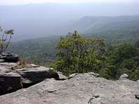 Plateau view
An interesting thing that makes Phu Kradueng unique is that hikers can buy refreshments at various rest areas, called "sam", along the way. These are wooden straw huts that villagers have set up for people to buy whatever they need. At first I didn't think I would like the sams but I was pleasently surprised and it was actually kind of neat. People were really nice and offered water to anyone who needed it. You could have Thai food cooked up in 20 minutes and have a cold drink. You can even order a Singha if you like.
 Phu Kradueng trail
The trail up Phu Kradueng starts right behind the visitor center. It is a steep climb but most people will have no problem if they take their time. The trail starts climbing immediately and gives a good indication of what the rest of the route will be like. Sam Haek offers your first viewpoint and food and water are available here. The trail levels off a little and goes through a nice area were ferns are quite plentiful all around the trail. It gradually starts climbing steeper and switchbacks are used to hike up. This is where we saw monkeys swinging in the trees. There were about a dozen of them.
The next sam is at Sam Kor Sarng. This is a little below the halfway point and where we decided to eat. After that you may notice that the scenery changes from tropical forest and you'll start seeing evergreen trees. There is a sign saying, "Be Careful for Elephants". Phu Kradueng National Park has elephants but they are shy animals and it isn't likely that you will run into them. The next sam is at Sam Kok Done. You'll know you're there because of the prominant Thai Flag near the building. There are restrooms here too. This viewpoint is a good one and you can see down into the valley.
The next sam is at Sam Krae. This is the last place where you can buy stuff. It's also the steepest part of the route. Stairs and ladders have been built to help people through this section. Hiking up this part is fun even if you're tired. Sometimes there were several different paths to choose from but they all lead to the same place. I watched as porters carried heavy loads with bamboo sticks on their shoulders while climbing up the steep stair cases. They are very strong people. Three sets of steps lead you up the final climb. Just when you thought you couldn't hike anymore you're at the top. It's a flat plateau with a lot trees and much bigger than I thought it would be. You will want to take your picture next to the large summit sign but you may have to wait in line. Take in the great views while you're there. Unless you plan on hiking along the plateau, hike back down the same way.
Elevation Gain - 3,650 feet, Round Trip Distance - 6 miles
Plateau Trails
Phu Kradueng only takes a day to climb but you will be missing out on some beautiful places. This requires that you camp for one or more nights on the plateau if you want to see them. There are over 30 miles of hiking trails that go to waterfalls, lakes, meadows, and cliffs. From the summit you will see two trails going around the rim of the plateau. There is a large map up there to help you choose your destination.
Waterfalls - there are too many to name but here are a few that you will want to see if you have time. Penpobmai Waterfall, Tat Hong Waterfall, Thamyai Waterfall, Pon-pob Waterfall.
Cliffs - the other major attraction. If you like cliffs like I do then you will want to hike to all of them. Lomsak Cliff is the signature landmark in the park. It is a large overhanging rock that juts out from the cliff face and is a favorite place to watch the sunset. Other cliffs can be seen and are well sign posted.
Essential Gear
You could actually do the whole hike without carrying much if you buy everything along the way. Bring money if you do. Meals cost around 30 baht which is cheap. I did the whole hike with a light day pack. It warms up in the afternoon and sunscreen will be a good thing to have. A good pair of shoes or hiking boots.