
|
|
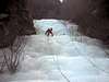
Canyon |
|---|---|
|
|
46.95231°N / 13.50563°E |
|
|
Overview
"Maltatal" is a great valley in Austria for climbing waterfalls. Almost always, the waterfalls are close to the road, so easy acces. As the valley is not very width, sunshine has not very much impact. "Close" to each other, there are over 20 routes of different difficulty.Getting There
How to get there. The most easy way is to travel by car to Malta. After a few kilometers you will see several waterfalls mostly at your left hand. However, there are also routes on your right site. Use this link to go to the overview maps of Maltatal:Red Tape
No fees at all. It is not allowed to camp in the wild. Use rooms in pensions in the small villages. Parking is easy. I saw a lot of cars standing aside the road. There is also a parking spot a few hundred meters after "Kerschhacklhof". Check it at the same site as mentioned before.When To Climb
Most waterfalls should not be climbed before January 1st. Reason is that most falls are on private property, which is used for hunting etcetera. The hunting season ends December 31st. It is allowed to climb some falls. Check the website mentioned before. As the waterfalls in Maltatal are not very expose to direct sunlight, the climbing season lasts longer. This year (2003) even up to the end of March. |  |
Mountain Conditions
The following website gives short descriptions/topo of about 15 waterfalls which can be climbed. Topos: SupermaxKerschhacklfall
Aluhol
Columbus (topo still under construction)
Strannerbach
Kathedrale
Gamseck
Wintasun
Superfeucht
Hochalmfall
Vorderer Maralmfall
Mittlere Maralmfälle
Hinterer Maralmfall
Grosser Klammfall ("Mareiner")
Kleiner Klammfall ("Marimpel")
Vorderer Keesbachfall ("Schweinchen Dick")
 |  |  |  |  |
External Links
- Topo of several waterfalls
On this site you will find very interesting information about the climbing possibilities in the Maltatal - Maltatal "The valley of tumbling water"
Short descriptions of waterfalls - Bergsteigen
For those of you who understand German,a useful page about ice fall conditions, weather etc.
triskelion - Mar 5, 2005 4:07 am - Hasn't voted
Untitled CommentThe best way to reach the Maltatal is to take take the A10 highway from Salzburg or Villach, get of the highway at Gmund drive through the village of Malta to the end of the road Falleralm (a restaurant). Either leave your car there if the road conditions up higher are bad, or continue up the road to the ice falls.
triskelion - Mar 5, 2005 4:17 am - Hasn't voted
Untitled CommentFor those of you who understand German, there is an Ice climbing guide book for the Carinthia Alps region, which includes the Maltatal valley.
Otherwise other useful links are:
www.bergsteigen.at (for those who understand German, weather, route condition info etc.)
www.planetmountain.com (in Italian and English, contains some info and topos)
www.maltatal-alpin.at (a home page for the Maltatal valley in German and English)
dmiki - Feb 11, 2008 3:45 pm - Voted 9/10
Trilanguage guideGerman - Italian - English http://www.edition-neumann.com/4_eisfall/140_angaben.htm