
|
|
Mountain/Rock |
|---|---|
|
|
33.39326°N / 4.6588°W |
|
|
Hiking, Mountaineering, Scrambling |
|
|
9163 ft / 2793 m |
|
|
Overview
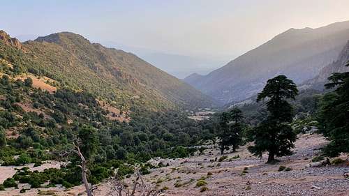
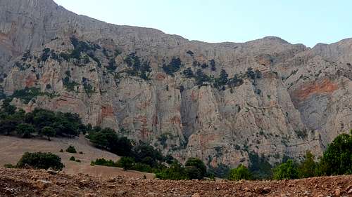
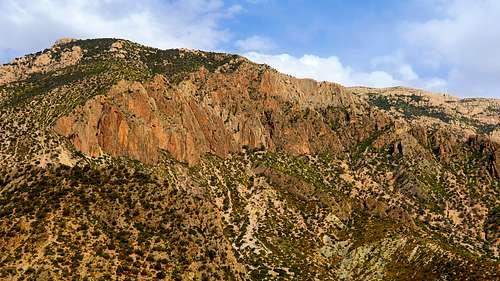
The Tichoukt Massif is the third highest ridgeline in the Middle Atlas Mountains of Morocco after Bou Naceur (3,340 m) and Jebel Moussa ou Salah/Bou Iblane (3,172 m and 3,081 m respectvely) though it easily has the steepest and most impressive north faces. Limestone cliff bands guard the summits of this massif from the north and vary from grey to red in color, with Oak and Atlas Cedar interspersed on hanging balconies. Below, talus slopes give way to Cedar stands and thick, though narrow, bands of Oak and Juniper forest. Wild boar, Barbary Maques and Quail are some of the more prominent species that live in these forests. The southern slopes fall away more gently - rocky barren expanses with a few eerie looking Cedar stands -- grey bones telling the story of a former glory. Snow covers these peaks each year though the season is shorter with most if not all the snow having melted away by late March or early April.
|
|
|
Getting There
BOULMANE (southwest of the Massif)
From Fes, take R503 south through the city of Sefrou all the way to Boulmane. You can get a Grand Taxi from Fes to Sefrou (by the Winxo Gas Station at the beginning of Route de Sefrou) changing taxi's there to continue on to Boulmane.
SKOURA M'DEZ (northeast of the Massif):
Alternatively, particularly if it has snowed recently, access is more likely from the northeastern town of Skoura. Take R503 from Fes, south to Sefrou. From there follow R504 east for 5 kilometers before heading south on P5033, east on P5016, south on P5105. Or, better yet, just look for directions on Google maps here. It is unlikely that you will be able to find a Grand Taxi from Skoura to Boulmane. You can hitchhike to Boulmane or consider climbing Jebel Assat, a subsidiary peak farther east and traverse along the ridge.
Route
There are no trail signs or properly maintained trails to lead to any of the summits along this ridge though faint sheep trails cover the slopes - reminders that our epic adventures are daily routine for the local shepherds. If starting from Boulmane, there is a forestry track that traverses 11 kilometers along the northern slopes from an elevation of 1850 meters up to 2100 meters. From here you pick your own route up slopes and gullies. The lack of trails or markers means that you must be competent with navigating according to geographic features and using a map as a rough reference guide. The 1:50,000 map is not incredibly useful for orienteering once you are on the mountain.
Red Tape
The Massif does have some form of conservation status however there are no fees for accessing the area.
When to Climb
Fall, Winter and Spring
Camping
As of 2019, camping in the wild can be unpredictable in Morocco in terms of authorization. If a Moroccan sees a foreigner setting up camp they will probably call their local representative (the Muqadam) who will almost surely come to your site and at the very least, take your details, including a photo of your passport or require you to return with them to camp in the vicinity of their house under a streetlamp. Their intentions are good and they desire only the best security for travelers. It is best to get permission from the Gendarmerie in Boulmane or Skoura who will probably require you to contract a licensed mountain guide. If you speak Darija, the local dialect of Arabic, you may be able to get permission from the local representative to camp up in the mountains if you convince them of your competence in the mountains.
External Links
http://gite-randonnees-moyen-atlas.com/