
-
 12386 Hits
-
 77.48% Score
-
 8 Votes
|
|
Canyon |
|---|---|
|
|
39.15820°N / 109.0317°W |
|
|
Hiking |
|
|
Spring, Summer, Fall, Winter |
|
|


Overview
Please note: McDonald Creek Canyon is part of the larger Colorado Canyons National Conservation Area, close to the Rabbit Valley area mentioned on the Black Ridge page, but not part of the Black Ridge Wilderness itself. I have attached this page to the Black Ridge one so it could be grouped with sites in its vicinity. There used to be a page for Colorado National Monument and its vicinity, where this page actually belongs, but it seems to have been deleted.
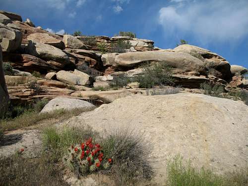
McDonald Creek Canyon is a short, easy, and scenic hike that offers ancient Native American rock art viewing, the streaked sandstone walls so emblematic of the Colorado Plateau, and a secluded overlook of the Colorado River, one of the principal architects of the myriad canyon wonders of western Colorado, southeastern Utah, and northern Arizona. McDonald Creek Canyon is part of the Colorado Canyons Recreation Area, administered by BLM, which also includes the outstanding Rattlesnake Canyon, where there is the country’s largest concentration of natural arches outside nearby Arches National Park in Utah. There are, however, no arches in McDonald Creek Canyon.
To pick up a good brochure with plenty of useful information, stop in at the Colorado Welcome Center just off I-70 near Grand Junction.
The hike is about three miles round-trip and doesn’t involve much elevation change. A sign at the trailhead shows some pictures of the pictographs and petroglyphs, but the information isn’t very useful in helping you know when and where to look for them. After the trail reaches the streambed of McDonald Creek, the first art panel appears after five to ten minutes of easy walking. It is on the left side of the canyon, on the wall, about fifteen feet above the streambed. This panel is easy to see. After this point, the canyon starts to feature high, colorful sandstone walls reminiscent of their bigger cousins in Arches, Canyonlands, and Zion National Parks.
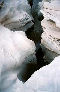
The next two panels, one on the east side and the other on the west, are supposed to be about half a mile from the trailhead and just beyond the dropoff (see photo). I did not see these panels, but perhaps more careful observers won’t have the same trouble. I did not spend a long time looking, either, and just moved on. Incidentally, the dropoff is an interesting spot and one of the neatest features of the canyon. The trail skirts it on the east, but it is easy to walk out across the rocks to the top of the dropoff, where the stream has carved what looks like a tiny slot. It takes a little more effort, but nothing monumental, to reach the streambed and walk up to the dropoff, and from this vantage, it seems less like a slot and more like a small cave. In any event, both ends are short, worthwhile detours from the trail.
Near the end of the trail, on the east side of the canyon, a short spur leads to and through a large alcove. This is where the fourth art panel is (look high). Finally, the trail twists through some denser vegetation and ends at train tracks, right on the other side of which is the Colorado River in one of its gentler aspects. Despite the train tracks, this is a secluded spot, and it could make for a nice afternoon to sit by the river and daydream, sleep, or read the hours away.
Getting There
The following directions are from Tony Huegel’s excellent Colorado Byways from Wilderness Press, and I recommend this book for anyone interested in the many scenic 4WD opportunities in Colorado.
“From Grand Junction, take I-70 west for 30 miles to Rabbit Valley (Exit #2). Cross the interstate on the overpass and go south through a large parking area for the Rabbit Valley Recreation Area. Cross the cattle guard; follow the road ahead.
“About 2.7 miles from that large parking area you will arrive at a huge, blob-like sandstone boulder (on the right) that looks like a gumdrop or a Hershey Kiss. Here, at Castle Rocks, go left…”
Once you turn left, you will be at the trailhead. Huegel indicates more driving being necessary, but none is, and perhaps things have changed since he wrote his description. There is a large sign and a register at the trailhead.
Some notes—
• 4WD won’t be necessary in dry conditions, but high clearance is a good idea and absolutely needed if you happen to take one of the rougher routes down to the canyon.
• Shortly past the large parking area near the interstate exit, the main road bends east. Do not follow it. Instead, take one of the roads heading south. This area sees a lot of ATV use, and some roads are rough for stock SUVs and trucks. The most direct route down is rough and caused a nice bang to the undercarriage of the rented Explorer I was driving. This will be no big deal for vehicles with skid plates, though. Instead of that most direct way down, look for other routes more to the southeast. They are gentler and take very little extra time.
Red Tape
Don’t touch the rock art.
Watch for livestock on the roads leading to the trail.
Watch for rabbits—the area seems appropriately named. Roadkill is sad but sometimes unavoidable, but it shouldn’t happen in off-road places where travel speeds are supposed to be much slower than they are on pavement.
Camping
There are a couple campsites on the way to the trailhead, and dispersed camping is widely available.
 By haytraci