Intro/Stats
"McReynolds Peak" (~12450')
8 miles RT, 2600' gain
Class 5.9 (aided)
Participants: Teresa Gergen, Kirk Mallory, John Prater, & Kevin Baker
From Gillette West Fork TH (9935')
Slideshow
From Gerry Roach's 12er notes:
"PT 12,438 on the Pikes Peak Quad. The map, despite its unusual 20-foot contour interval, is inaccurate in the vicinity of this peak. It shows three north-to-south summits, with the north having one higher closed contour than the middle and south, and suggests low-angle, uninteresting terrain. Actually, severe granite spires punctuate the rolling tundra. The highest of these is on the middle summit, and is a Class 5.9 ascent."
From legendary CO mountaineer Ken Nolan, completer of all ranked summits in CO over 12K':
"Of all Colorado peaks above 12,000’, the most technically difficult summit to reach is Unnamed 12438 on the ridiculously-inaccurate Pikes Peak quad."
Holy smokes, how is a peon like me going to get up this beast! I initially heard about this obscure but difficult peak s.w of Pikes on a 14erworld thread back in 2005 discussing the hardest peaks in CO. I looked at the map and noticed it was barely in Teller county, so no need to climb it, right? Funny how lists change. Now only 2 years later I am starting on the Teller county ranked summits list and the mountain is taunting me to be climbed. The only way I could get up this was via rope tricks after a strong climber could set an anchor for me on top, so I lured John Prater to join me. I knew Teresa Gergen and perhaps Kirk Mallory would need to climb it since they are working on the 12ers, so I invited them and they joined the fun as well! Now all we had to do was figure out the access issues and what gear we needed.
McReynolds is sandwiched between the C. Springs watershed on the east side and some Cripple Creek reservoirs on the west side. According to some info on the Pikes Peak page on summit post, a route up the West Fork drainage is a viable option. The road is shown on the C. Springs Pikes Peak Trail & Rec map as an access to the national forest, so we decided to give this a shot. Kirk and Teresa checked out the trailhead the night before and their were private property signs, but nothing that said "no trespassing". A cop pulled over while they were checking it out and thought it would be OK to hike up the road.
The Hike
We all met at the Gillette TH at the intersection of CO-67 and CR-81, which is the split for Cripple Creek and Victor. We parked on the west side of the road and set out at 7:02 under crisp, clear skies. We followed the road east for a half mile or so until it curved north, where we picked up a closed road that met up with a road from the south at the top of a steep hill. From here, we followed the road to the 1st reservoir. There were signs of housing construction in this area with some ladders in the middle of the road. Maybe we should have grabbed one for the summit block!
From the reservoir, we decided to leave the road and bushwack n.e. to a minor ridge. The bushwacking wasn't bad at all and we made good time up to the ridge. John found a decent trail that we followed all the way to a meadow at around 11K', which was very nice. The snow was patchy and wasn't enough to really need gaitors. Once at the meadow, our remaining route to the summit was obvious, as we hiked up moderately steep tundra slopes to the south ridge.
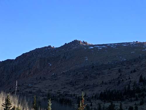
![McReynolds Pk s.w. slopes]() The moderate s.w. slopes of McReynolds.
The moderate s.w. slopes of McReynolds.
The Pikes Peak quad has 20' countours, so the terrain looks much steeper than it is. It is also wildly inaccurate as the playground of sharp boulders on McReynolds summit isn't shown at all.
![McReynolds Pk from south]() Nearing the summit boulders of McReynolds.
Nearing the summit boulders of McReynolds.I Gotta Climb That?
We made it up to the summit area around 9:35 and it didn't take long to locate the summit boulder as Ken Nolan had sent Teresa a pic of it. The east side looked pretty smooth, gnarly, and vertical with a crack up the middle.
![Summit block (east face) of McReynolds Peak]() The vertical east face of McReynold's summit block.
The vertical east face of McReynold's summit block.
We knew that Ken Nolan and Jean Aschenbrenner had gone up the west side, which might be easier. Unfortunantly this side was in the shadows and was pretty windy, so it would be a tough go over there.
![McReynolds west face]() The easier but colder west face of McReynolds.
The easier but colder west face of McReynolds.
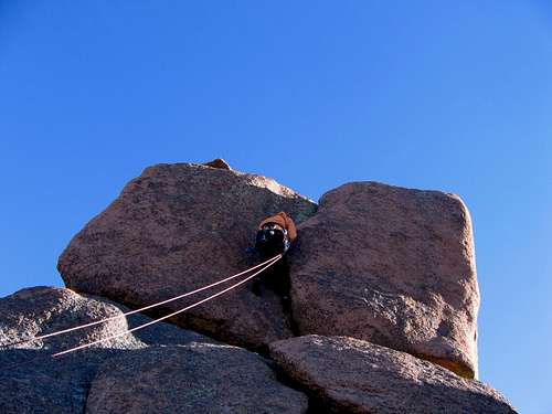
It was 37 degrees, so not exactly ideal conditions for a rock climb. We geared up on the sunny side and John decided to lead the west face. The slabs at the bottom are 4th class until you get to the vertical crack. The boulder is rough Pikes Peak granite with few handholds, perhaps 15' high. John had a rack of various large cams, and I think he used a #4.5, a 5, and a 6 Camelot, although I might be off. I think he used a #2 higher up when the crack narrowed. John's hands got pretty cold, but he perservered and topped out. Now it was my turn.
![McReynolds Pk ascent]() John Prater aid climbing up the 5.9 summit block.
John Prater aid climbing up the 5.9 summit block.
I knew I had pretty low odds of climbing this 5.9 summit block even while grabbing the gear for holds, but I gave it the old college try. I made past the first couple cams but gave up as my hands were getting real cold and it was tough trying to unclip the cams from the rope.
![My futile effort on 5.9 McReynolds]() A futile effort on my part of aid climbing up the west face.
A futile effort on my part of aid climbing up the west face.
I retreated and warmed up in the sun, while Teresa made quick work of the aid climb!
![Teresa Gergen on McReynolds Pk]() Teresa Gergen cruises shows how it's done up the west face.
Teresa Gergen cruises shows how it's done up the west face.
Time to resort to rope tricks. I have only prussiked a couple times and thought this would be fun, but it was much tougher than I imagined at altitude. I decided to go up the east face since it was nearly vertical and the rope probably wouldn't get caught as much. Moving the prussiks up was slow going as there was a bulge in the face that was hard to slide the knots past as I kept shifting my weight from one knot to the other.
![Prussik action on McReynolds Pk]() My only hope was to prussik up the east face, which wasn't exactly easy!
My only hope was to prussik up the east face, which wasn't exactly easy!
After what seemed like an eternity of huffing and puffing, I pulled my sorry butt onto the summit block at 11:45am. Kirk went next and use the Texas prussik, which gives you two prussiks to put your feet in. He thought it was pretty tough too and was relieved to be on the summit.
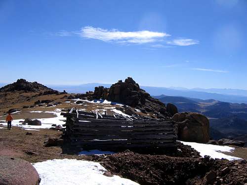
The register was placed by Gerry and Jennifer Roach in 2001 and had seen no entries since. Ken and Jean didn't sign it when they were there, so Teresa signed them in. Mike Garratt had summitted since then as well. I doubt if this summit has seen more than 10 ascents. The rappel was a bit awkward for me on top, but once over the edge it was smooth. John rapped off the west face to clean the gear, and we headed over to the northern false summit. We visited a couple areas here, one of which was two large boulders with a chimney betwen them that John clammored up. There is also a summit just a few feet to the south of the highpoint probably no more than a foot or two lower that was low 5th class. This area looked similar to Stonehenge with all of the unusual boulders scattered about in erratic positions.
![McReynolds Pk jumble of boulders]() An old mine near the northern false summit and the true summit in background.
An old mine near the northern false summit and the true summit in background.Are We Trespassing?
After nearly 4 hours in the summit area, we headed down at 1:20. In order to avoid private property issues as much as possible, we decided to stay in the trees on the ridge. We followed our ascent route down a flat area at around 10600', then bushwacked down a ridge to about 10200'. We made pretty slow progress as the brush was thick. We came across an odd 10' fence and soon heard some voices in the woods. Could they be hunters?
A few minutes later we saw a couple cars driving up the road below us, so we sat down and hid like little kids playing hide and seek! I didn't mind just walking down to the valley and playing dumb, which is what we ended up doing. We hit a road and the woods were signed, so we stayed on the road all the way back to CR-81 just south of the TH. One resident drove by us but didn't stop. It was an entertaining day on a tough 12er. We arrived back at the cars at 4pm. Thanks to John, Kirk, and Teresa for helping me up this one!


Comments
Post a Comment