
-
 12590 Hits
-
 82.48% Score
-
 15 Votes
|
|
Area/Range |
|---|---|
|
|
Hiking, Scrambling |
|
|
Spring, Summer, Fall |
|
|
10162 ft / 3097 m |
|
|
Overview
 North Big Horns
The most famous mountains in the Big Horn Range in north central Wyoming are contained in the southern part of the range in the Cloud Peak Wilderness, with mountains like Cloud Peak and Black Tooth Mountain rising to over 13,000 feet in jagged spires and impressive rock faces that overlook wild country that is dotted with numerous lakes, grassy plains and hills, and forested areas. The peaks in this area often require several days to climb due to the greater distances from established roads to the mountains themselves, and many of these peaks offer formidable technical challenges to climbers.
 Sheep, Cone, and Duncum Mountains
 Peak 9953
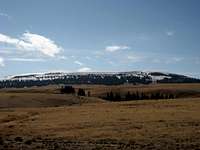
The southern part of the Big Horns contrasts sharply with the northern half of the range, where the gently rolling mountains offer hikers a treasure trove of summits that are reachable in short amounts of time. These mountains generally offer nothing harder than a Class 2 scramble, and the amazing views from the tops of these peaks offer huge returns on the relatively small amounts of time and effort invested to climb them. The mountains on this page are all accessed from Highway 14A, which is known as the Medicine Wheel Scenic Byway, and are close to roads for the most part; a round trip hiking one of them usually runs between 1.5 and 4 miles from your car.
 Bald Mountain
 Hunt Mountain
Hunt Mountain and Bald Mountain are the two highest points in the northern Big Horns, reaching over 10,000 feet, and there are at least a dozen other mountains between 8,000 and 10,000. Due to their relative proximity to each other, it is possible to reach quite a few summits in a day; for example, I was able to reach the three highest points in the area in a six-hour period.
 Medicine Wheel
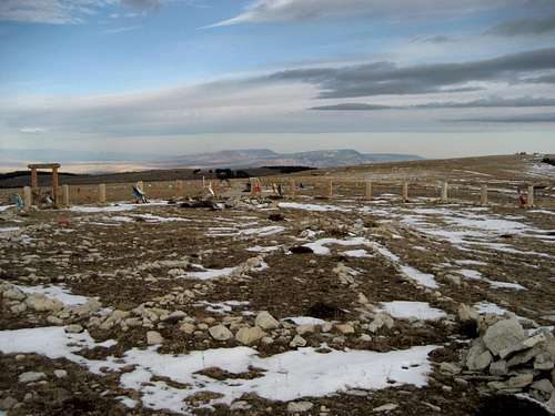
This area is named after the Medicine Wheel, which is an ancient stone circle that lies on the northwest ridge of Medicine Mountain. Its age and exact purpose are a mystery, but its 28 spokes and the cairns inside the circle line up with important stars and constellations in the night sky. It is a place of great religious significance to many people, and the enclosing fence is adorned with a wide variety of objects left there as prayers and offerings from those who hike the 1.5 mile trail to see it.
This area has an abundance of wildlife, and White-tail Deer, Mule Deer, Pronghorn Antelope, Elk, Moose, Black Bears, Coyotes, Wild Turkeys, Golden Eagles, Bald Eagles, Falcons, Sage Grouse, Ruffed Grouse, and Pheasants can be found in the area. The wildflowers in the summer are breathtaking, and over 1,000 miles of trails allow the hiker to fully explore the many facets of this truly beautiful area. In winter, snowmobiles are the preferred method of transportation in the Big Horns.
Getting There
 Highway 14A
The Medicine Wheel Passage (Highway 14A) runs west from Burgess Junction and runs for 52 miles out of the Big Horn Range into Lovell, WY. The table below lists the most important roads and trails used for accessing peaks and other sites in this area.
| Road | Mountains/Sites Accessed |
|---|---|
| Forest Road 12 | Medicine Mountain Medicine Wheel Historic Site |
| Road 130 | Bald Mountain Bald Mountain Campground |
| Forest Road 11 (and branches 125, 134, and 14) |
Bald Mountain City (Ghost Town) Rooster Hill Burnt Mountain Duncum Mountain Cone Mountain Sheep Mountain Boyd Point Leaky Mountain |
| Road 122 | Bald Mountain |
| Forest Road 15 | Little Bald Mountain |
| Forest Road 10 | Hunt Mountain |
| Road 178 | Peak 9953 (Tongue River Peak) |
| Trail 018 (Fishook Creek) |
Peak 9634 (Fishook Mountain) |
|
Forest Road 15 (at Burgess Junction) |
Twin Buttes |
The forest roads are generally well-maintained and can usually be traveled in any car, but 4WD is necessary for some of the smaller roads.
Mountain List
This is a list of the summits in the northern part of the Big Horn Range which are accessed by Highway 14A. There are other unnamed points in this area over between 8,000 and 10,000 feet, so if you climb any of them or have any additional information, please send me a PM so I can add them to this list.| Image | Peak Name | Elevation | Prominence | Quad | Map Link |
|---|---|---|---|---|---|
 |
Hunt Mountain | 10,162 | 1,142 | Leavitt Reservoir | Map |
 |
Bald Mountain | 10,024 | 822 | Bald Mountain | Map |
 |
Medicine Mountain | 9,962 | 862 | Medicine Wheel | Map |
 |
Peak 9953 - Tongue River Peak | 9,953 | 693 | Ice Creek | Map |
 |
Little Bald Mountain | 9,907 | 407 | Bald Mountain | Map |
 |
Duncum Mountain | 9,831 | 891 | Bald Mountain | Map |
 |
Sheep Mountain | 9,813 | 553 | Mexican Hill | Map |
| (No Image) | Peak 9634 - Fishook Mountain | 9,634 | 454 | Ice Creek | Map |
 |
Burnt Mountain | 9,492 | 512 | Bald Mountain | Map |
 |
Cone Mountain | 9,469 | 209 | Medicine Wheel | Map |
| (No Image) | Rooster Hill | 9,420 | 320 | Bald Mountain | Map |
 |
Big Horn County Highpoint | 9,257 | 408 | Bear hole | Map |
| (No Image) | Peak 9150 - Bear Creek Mountain | 9,150 | 610 | Bald Mountain | Map |
| (No Image) | Peak 9140 - Dayton Gulch Peak | 9,140 | 368 | Ice Creek | Map |
| (No Image) | Peak 8610 - Horse Ridge Peak | 8,610 | 393 | Boyd Ridge | Map |
| (No Image) | Dry Fork Ridge East | 8,548 | 1,068 | Burgess Junction | Map |
| (No Image) | Dry Fork Ridge West | 8,500 | 1,157 | West Pass | Map |
 |
Peak 7630 | 7,630 | 220 | Medicine Wheel | Map |
| (No Image) | Fisher Mountain | 7,393 | 693 | Bull Elk Park | Map |
Red Tape
There are no fees to hike in this area, and access to most areas is very easy. Highway 14A, the Medicine Wheel Passage Scenic Byway, is closed during much of the winter, depending on the amount of snowfall.Fast-developing storms are common throughout the Big Horns, so keep an eye on the weather at all times. For an great read involving a storm in this range, read Bob Sihler's excellent trip report on Peak Angeline: https://www.summitpost.org/trip-report/263773/DON-T-Take-My-Wife-Please.html
Black bears, moose, and mountain lions can encountered at any time in this area, so be prepared with bear spray and know how to deal the situation if you happen to meet one of these animals.
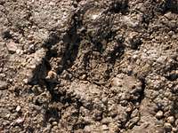 Bear Track near Bald Mountain
Camping
Places to camp in the Big Horns are numerous, with the majority of the range being open to dispersed camping. Camping is not allowed within 100 feet of lakes or streams, or within 1/4 mile of major roads. Camping is limited to fourteen days at a site. For complete rules and regulations, visit: http://www.fs.fed.us/r2/bighorn/recreation/camping/External Links
Sites about the Medicine Wheel:http://en.wikipedia.org/wiki/Medicine_Wheel_National_Historic_Landmark
http://solar-center.stanford.edu/AO/bighorn.html
Bald Mountain City:
http://www.ghosttowns.com/states/wy/baldmountaincity.html