
-
 17911 Hits
-
 82.27% Score
-
 15 Votes
|
|
Mountain/Rock |
|---|---|
|
|
44.81690°N / 107.9024°W |
|
|
Big Horn |
|
|
Hiking, Scrambling |
|
|
Summer, Fall |
|
|
9962 ft / 3036 m |
|
|
Overview
 Medicine Mountain
 FAA Radar Dome
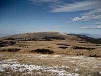
Medicine Mountain is a peak on the western edge of the northern Big Horn Range in Wyoming that provides great views of the entire Big Horn Basin and the Absaroka Mountain Range. The famous Medicine Wheel, an ancient stone circle with twenty-eight spokes, is found high on one of the ridges 1.5 miles northwest of the summit. Medicine Mountain is easily recognized from a distance by the large spherical FAA radar dome on its summit, which is used for monitoring air traffic over Wyoming and Montana.
 Looking down into the Big Horn Basin
Getting There
 Seen from Bald Mountain
From Lovell, Wyoming, take U.S. Highway 14A heading east for about 23 miles and turn left on Road 12, which is clearly marked as the turnoff for the Medicine Wheel site. To approach from Sheridan, Wyoming, follow Highway 14 to Burgess Junction, turn right on Highway 14A, and travel for 21 miles. Medicine Mountain is north of the highway and is hard to miss because of the gigantic radar dome on top. Continue on Road 12 for about 2 miles and you will reach a parking lot with restroom facilities and information on the Medicine Wheel, which is reached from this lot by hiking for about 1.5 miles on the trail that winds around the mountain. There is a gated road, blocked to vehicle travel, that branches off to the left and heads up to the summit.
The top of Medicine Mountain is easily reached by hiking up this road for 3/4 mile and about 400 feet of elevation gain. If you're looking for something longer and more interesting, try parking off of the highway and scrambling up the south side of the mountain, which will entail a scramble of 1100 feet of elevation gain over one mile. From the top, it is possible to scramble down the north side of the mountain to connect with the trail to the Medicine Wheel site, which is well worth the walk to see. There are teepee rings on the ridge north of the Wheel, but I did not have the time to find them while I was up there.
 Sunrise from the summit
Red Tape
Access to this area is very easy except during the winter and early spring, when Highway 14A is closed. The Medicine Wheel site will occasionally be closed to the public without much notice when requested by Native Americans for use in ceremonies or religious observances.This area has an abundance of wildlife, so be especially aware of moose, elk, black bears, and mountain lions when hiking in this area. There are no grizzlies in the Big Horns.
Camping
Places to camp in the Big Horns are numerous, with the majority of the range being open to dispersed camping. Camping is not allowed within 100 feet of lakes or streams, or within 1/4 mile of major roads. For complete rules and regulations, visit: http://www.fs.fed.us/r2/bighorn/recreation/camping/The nearest campground is Bald Mountain Campground, located 3/4 mile east of the turnoff to the Medicine Mountain/Medicine Wheel area.
External Links
 Medicine Wheel
http://en.wikipedia.org/wiki/Medicine_Wheel_National_Historic_Landmark