
|
|
Mountain/Rock |
|---|---|
|
|
50.16986°N / 17.30621°E |
|
|
Hiking, Skiing |
|
|
Spring, Summer, Fall, Winter |
|
|
3990 ft / 1216 m |
|
|
Rejvíz massif (Medvědská hornatina)
 Rejvíz peat bog
 Peat bog
 Seen from Jesenik spa
 Fine architecture in Rejvíz
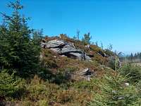 Gneiss outcrop and summit landscape
 Winter Sunset
Medvědí Vrch (or Medvedí Hora), with is neighbour Orlik, are the culminating points of a vast mountainous region of the Jeseníky, that extends East from the eponym town, and South from Zlaté Hory. We call it Medvědská hornatina (Bärenfang-Bergland in German), or sometimes Pásmo Orlíka.
The range is rather gentle in slope, covered with spruce forests, and undulating like a sea of firs. Many trails go through it (photos), with a fair number of them covered with asphalt, which makes it a great terrain for ski-touring and biking (see MBpost page). Like Keprník and Praděd, to which we get splendid views, few layered gneiss outcrops can be observed here and there.
With these mensurations, we can reasonably speak about the fourth giant of the Jeseníky, but unfortunately the top Medvědí Mrch is kind of disappointing. The sub-alpine area is a messy zone of broken trees, like if a cataclysm happened there recently. Flown in high grass and wild vegetation, the top barely allows views (we get them rather on a couple of viewpoints aside), which is a pity.
Medvědí Mrch definitely deserves some outlook tower, and having its last portion of trail maintained. It would make a great destination for tourists on foot, ski, or bike.
However the range owns many other attractions. Over Zlaté Hory, on the south, is located the highest village in Czech republic, Rejvíz, a very beautiful settlement of wooden houses in the local style.
Nearby is located the eponymous largest peatbog of the Sudetes.
The goldmining watermills of Zlaté Hory are also a famous touristic attraction in the region, and this location is a hub of many interesting trails.
 Mountain panorama near Rejvíz Mountain panorama near Rejvíz |
Getting There
 The goldmining watermills
 Local wooden house
 River in Zlaté Hory
 Nice vegetation
 Dry trees
 Endless trails
 Directions...
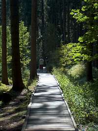 Peat bog trail
Paradoxally, this Czech mountain is best reached... from Poland. Especially if we want to visit it in the same time than its touristic features, Zlaté Hory and Rejvíz which are on the north.
Głuchołazy is the "polish gateway" to the Jeseníky, and can be reached either via Nysa or Prudnik, depending if we come from Wrocław or rather Opole on the A4.
From Czech Republic, the town of Oloumoc is the best way to reach the mountain, via Karlova Studánka and Vrbno pod Pradědem.
View Larger Map
 Road panorama near Rejvíz Road panorama near Rejvíz |
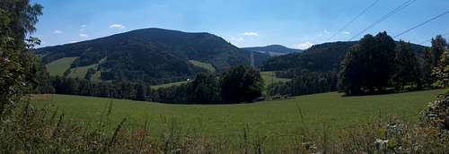 Road panorama near Rejvíz Road panorama near Rejvíz |
Routes
 The goldmining watermills
 Goldpanning competition
 Lone forestry house on Orlik
 Dome of Orlik
 Ravaged forests on top
 Gneiss outcrop
The top itself it not served by any marked trails, however there are large unmarked trails leading to it, connected to maked trails nearby.
Wherever we come from, all trails converge to a large junction titled "Pasmo Orlika".
The junction "Pasmo Orlika" can be reached from many points:
- From zlaté Hory, the green trail takes us along the gold-watermills until Rejvíz. After having a glance to the nearby peat-bog, we follow the yellow-marked trail leading south.
- From Adolfovice, south from the city of Jesenik, the green trail reaches the same point.
- From the pass "Vidly" SE from Bělá pod Pradědem, the earlier mentionned yellow-marked trail leads there in the opposite direction. The most direct route, instead of being the most interesting.
- From Vrbno pod Pradědem, the green-marked trail elevates NW in the direction of a point that will be described below, before the juction "Pasmo Orlika".
Focusing again on the junction "Pasmo Orlika", here is how to reach the summit. The green-marked trail going SE goes east for a short section until a point located almost in the middle of the pass between Orlik and Medvědí Vrch. Many secondary trails and tracks are drawn on the map, but in the reality there are not so many, partly due to the state of the forest. From the green trail, the best option is to elevate NE in the direction of the pass, on a large track soon turns SE, and goes on the south side of the top. As we reach the highest point of this track, a secondary path appears on the left. It reaches the trail to the top of Medvědí Vrch that corresponds to the mathematic straight line to Orlik.
If we descend later via this line, unlike what the map shows, it doesn't reach Orlik but connects to the unmarked land-rover track located on the NE slope. This track, after many laces and long way in the forest, gets back to the red-marked cycling path E55 on the east of the massif.
Orlik cannot be reached this way because of fences in the broken forest.
One can see a little house on Orlik and wonder what this is, as well as how to reach it. It is done by using the descent route earlier mentionned. At the level of a hunting tower, at a perpendicular level of Orlik, is located a land-rover trail that serves it.
 Endless local trails Endless local trails |
 Endless local trails Endless local trails |
Accomodations
 Trail near Rejvíz
 Wild forests
 Cows...
 Sheep...
 First sight out of the forest
 Little stream...
 East trail
 River near Rejvíz
- Wild camping and bivouacquing: Considering how wild is the range, no issue connected with the regulations, if you do it out of inhabited areas. The problem will perhaps to find a suitable piece of grass to pitch a tent. For information, all big predators are officially extinguished in the Sudetes. But the eastern Jeseníky are the closest area from the Moravian Carpathians which own lynxes, wolves and bears. During those times of reconquest of the lost lands by mother nature, there are regularly rumours of punctual returns of those former locators...
- Mountain huts : none.
- Accomodations : One will find a lot of them in touristic resorts, like Rejvíz, Jesenik, Adolfovice, Bělá pod Pradědem
 Orlik panorama Orlik panorama |
 Summit Panorama Summit Panorama |