
-
 11903 Hits
-
 77.48% Score
-
 8 Votes
|
|
Route |
|---|---|
|
|
43.60520°N / 116.0613°W |
|
|
Hiking |
|
|
Spring, Summer, Fall, Winter |
|
|
Less than two hours |
|
|
Overview

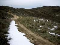
The Mine Loop on Lucky Peak provides single track trails, scenic views, no crowds, and it's located just 10 minutes from Boise. The preferred loop starts at the Highland Valley Road gate on ID-21, just south of Highland Valley Summit. This gate is typically closed from November to May, but that may vary according to weather and fires. From here, follow a well traveled jeep road west to Pt 3789 where you'll leave the Highland Valley Road (historic) and turn right (north). About 1/4 mile from this junction you'll find a single track trail cutting across the road from both directions. Take the right (northeast) single track as it climbs steeply at first, levels off, then climbs steeply again, before finding the jeep road again after 1.7 miles of narrow trail. Either take the Mine Loop road or the main road. If taking the Mine Loop, take the second right down to the Black Hornet Mine (marked on the USGS). If taking the main road, follow it steeply to the next junction after a cattle guard. Take the right down a steep hill and find the same junction described in the last sentence (left this time to the Black Hornet Mine).

The Black Hornet Mine is just a remnant area of late 1800's to early 1900's mining. Plenty is left in the form of building foundations, tailings piles, and rock outcroppings. The trail narrows to a single track again as it passes through this area, then climbs steeply north to a small saddle and junction with the Fish & Game Road. Looking down into the valley just north of here is several large mining buildings in really good shape. This area is called the Adelmann Mining Area and these were used last in the mid 1900's.

From the Adelmann saddle, follow the jeep road up and north to reach the summit of Lucky Peak. The road actually connects to the main road again, north of the summit after passing through the pine trees. Snow lingers late in this upper northeast area. To complete the loop, go right and downhill from the Adelmann Saddle. Follow this road east toward the Fish & Game (Boise Wildlife Management) Office. You'll pass the Fish & Game Boneyard, where they dump all the roadkill from the local highway. Every so often they take a bulldozer and bury the bones, but the area is usually full of carcasses and bones from mostly elk and deer. Common visitors to the Boneyard include crows, birds of prey, and coyotes. You'll reach the back of Fish & Game (public access is okay) and ID-21. Walk up and over Highland Valley Summit on ID-21 (briefly) to reach the parking area.
Mine Loop from upper Highland Valley Road parking: 9.8 miles and 3032 feet gain (loop)
Mine Loop from upper Highland Valley Road parking with a excursion to Lucky Peak Summit: 12.7 miles and 3734 feet gain (loop)
Activity Matrix
| Activity | Rating 1-10 | Required Experience |
| Rock Climbing | 0 | n/a |
| Alpine Climbing | 0 | n/a |
| Hiking / Scrambling | 6 | beginner |
| Trail Running | 7 | intermediate |
| Mtn Biking | 8 | intermediate |