
|
|
Mountain/Rock |
|---|---|
|
|
45.59240°N / 115.6654°W |
|
|
Idaho |
|
|
Hiking |
|
|
Summer, Fall |
|
|
8500 ft / 2591 m |
|
|
Overview
 Mineral Hill and Bear Lake
 East side
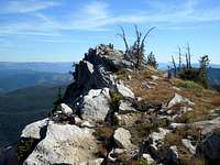 The summit
 Summit ridge
Mineral Hill is interesting as it’s really more of a tilted plateau edge than a mountain, yet it’s the third highest summit in the Gospel Hump of north central Idaho. It forms the divide between the East Fork of Sheep Creek and Jumbo and Lake Creeks. This high plateau area in the eastern Gospels is slightly tilted up to the east with gentle slopes covered with ponds and wetlands on the west side and abrupt cliffs and precipitous slopes influenced by glaciation on the east side. Depending on where one stands the hill rises 800 – 1200 feet on the west side and about 3,000 feet above the east base. The east side supports four lakes, Ruby, Bear, Crescent and Square as well as Fish Lake in the bottom of Lake Creek and some smaller ponds. The mountain has 700 feet of prominence.
The actual summit is just outside of the Gospel Hump Wilderness boundary in a linear segment excluded for extensive patented mining claims. Much of the eastern flanks and connecting ridges are included. This allows motorized access to get very close to the mountain, in fact a road cuts across the west aspect not far below the summit. However, the road is not well maintained and travel is more appropriate for OHV than cars or even most trucks. Getting to the area under motorized conveyance is extremely difficult as described below. Simply getting to this mountain is far more difficult than ascending it.
The area has a rich mining history. It’s hard to imagine today, but at one time this empty, primitive area supported several mining towns, Concorde, Humptown and Frogtown. These short-lived, lawless communities provided the needs for thousands of miners from the late 1800s into the early decades of the 1900s. At their height of activity there were several saloons, brothels, motels and thousands of grazing livestock to provide food. This is perhaps the only designated wilderness where one can stand in places formerly inhabited by thousands of people, but virtually all traces of these communities are now gone. However, with current mineral prices, some of these mines are being worked again and a small population of locals is always present.
The mountain is composed largely of granodiorite associated with the Idaho batholith, but also is infused with quartz veins immediately adjacent the west slopes. The higher elevations are covered with very open subalpine fir and whitebark pine growing on a very depauperate, powdery, decomposed granite soil. This unusual habitat supports Idaho Douglasia which is a beautiful plant endemic to a few mountain tops in central and north central Idaho.
 North bowl
Getting There
 The west aspect.
 Below Hump Lake
 North approach
 South ridge
 ATV mess
 Ridgeline
From Highway 95, turn east into Grangeville and continue on main street (Highway 13) for a long mile to the east edge of town. Town ends abruptly at the former Forest Service office on the northeast corner of the intersection of Highway 13 and the Mt. Idaho Grade road. From this intersection go south (right from downtown) on the Mt. Idaho Grade road. After driving approximately 0.7 miles take the curve to the left at the drive-inn theater. Continue on through the cluster of houses known as Mt. Idaho and soon the road will descend into the deep canyon of the South Fork of the Clearwater River. The road hits the canyon bottom and Highway 14 joins from the left, 9 miles after the theater curve. Proceed straight or up river. This road is very narrow and curvy, especially the first several miles. Logging trucks and RVs are common so stay on your side of the road and hope they do the same.
The South Fork Clearwater is a small, but beautiful river. The steep grade over endless boulders yields class III, IV, and V whitewater in the spring. About 10-15 miles upstream the canyon tightens into a spectacular gorge with miles of technical climbing that is seldom utilized. Low elevation mountain goats are not an uncommon sight here. All is especially beautiful in the fall when the larch and broadleaf trees lining the rocky stream turn gold. The river also supports good runs of steelhead and Chinook salmon, which can be seen jumping some of the small waterfalls during the appropriate season.
After driving up river for approximately 35 miles turn right on the Crooked River road #233. This turn is across a cement bridge about 100 yards before mile marker 43.
Proceed up this road for approximately 18 miles to Orogrande Summit. Past the small cluster of seasonal cabins of the Orogrande townsite (approximately 11 miles in) the road becomes fairly rough, but will be passable for most vehicles. From Orogrande Summit on however, your options depend on your vehicle, your driving skill and your nerve.
From Orogrande Summit you can park and walk the road to Hump Lake, but this is approximately seven miles on the road. If you choose to continue to driving south on the 233 road beyond Orogrande Summit, proceed cautiously and hope no other vehicles come from the other direction. If you have high clearance you shouldn’t have too much trouble for a while, but there are a couple spots you likely won’t get back out on the return if you don’t have 4wd. After about 2 miles you come to Lake Creek. Again you can park here and walk the road (boulder) bed to the mountain, which is now about five miles further. If you have a good 4wd, and want to continue on the road, put it in 4-low and patiently creep on. The road beyond Lake Creek soon becomes nothing but a boulder bed that seasonally runs with water. Just before the road starts the climb out of the canyon, there is parking for 2 or 3 vehicles around the Crackerjack Mine road junction or a little beyond at the Vesuvius Mine. This is as far as I would go. To walk from here is about three miles to the mountain.
Beyond the Vesuvius Mine, the road (or path) that climbs up the headwall, offers great views of the glacial valley and surrounding mountains. The steep rocks are broken up by several small meadows that are wonderful wildflower gardens in July and much of August. The road up the headwall is very steep rock with large fixed boulders, wide cracks and some 1-2 foot vertical steps. Some try to drive it with 4-wheelers. A man told me he once put his pickup in low gear and then walked beside it with a hand through the open door to hold the steering wheel. In the last couple years some miners have used heavy equipment to improve parts of the road so it is easier for a 4-wheeler and more adventurous 4wd drivers. But still don’t try to drive this unless you really know what you are doing.
Once at Hump Lake, the hard part is over. You’re finally ready to head to the mountain itself. Keep to the left at the main trail intersection where private cabins are visible to the right. The mountain from this north vantage will look like little more than a tilted ridge above the general landscape. In about a mile the north ridge provides a nice easy hike from the road or one can continue on and hike up anywhere from the road. The climb itself isn’t much of anything, but it’s a nice day getting her and being in this beautiful high country.
Red Tape
Part of the area is included in the Gospel Hump Wilderness and standard wilderness regulations apply. There is also a fair bit of private ground scattered in the area so be aware of private property.Camping
 Bear Lake
 Crescent Lake
At large camping can occur almost anywhere in the high subalpine country. Be aware of the private land around Hump Lake. The mountain lakes on Mineral Hill are not very accessible, but there is a sliver of public land bordering the northwest shore of Hump Lake. Wild Horse campground provides a good base for pack trip into the mountain general area. There are at least five primitive campgrounds between Highway 14 and Orogrande Summit as well as good dispersed camping south of Orogrande along the upper Crooked River.
 A pond near the Concord site.
When To Climb
The climbing season is during the summer and fall, but even during summer snow is possible. Winter climbing is difficult because access routes are not seasonally maintained. To get there in the winter will require well planned snowmobile and snowshoe excursions.Mountain Conditions and Additional Information
 North bowl
While this is a relatively safe mountain with easy terrain and access, be sure to go to the mountain prepared for variable conditions. Weather and temperatures can vary dramatically between the canyons and the mountain. The arid lowlands in the Gospels may commonly be well above 100 degrees in the summer, while temperatures can be dramatically different near the summit. Also the mountains in the area typically see nice clear skies early followed by sometimes severe thunderstorms in the afternoons.
For more information and current conditions contact the Nez Perce National Forest or the Salmon River Ranger Station.
Nez Perce National Forest
104 Airport Road
Grangeville, ID 83530
208-983-1950
Salmon River Ranger District
Slate Creek Ranger Station
HC 01, Box 70
Whitebird, ID 83554
(208)839-2211
FAX:(208)839-2730
NOAA Forecast
 Southeast aspect of Mineral Hill