
|
|
Mountain/Rock |
|---|---|
|
|
45.64730°N / 115.6843°W |
|
|
8818 ft / 2688 m |
|
|
Overview
North Pole is the second highest point in the Gospel Hump Wilderness of the Nez Perce National Forest. It is a long, fairly nondescript high ridgeline situated to the north of the area’s highest mountain, Buffalo Hump. Most the routes to the top are easy walks, but some more involved approaches and scrambles can be had as well. The view from the top is spectacular with four states being visible; the Wallowa Mountains of Oregon, Bitterroots of Montana and the Blue Mountains and prairies of southeast Washington. The Gospel Hump Wilderness is approximately 206,000 acres and forms part of a 4.3 million acre wilderness block with the Frank Church River of No Return Wilderness and the Selway Bitterroot Wilderness. North Pole is not generally a destination hike, but rather the high point on the trail to several subalpine glacial lakes, many of which support good trout fishing. There is no summit register, only the remains of an old lookout and a pile of rocks.The area has a rich mining history. It’s hard to imagine as one looks out over the high subalpine plateau southeast of the mountain that at one time this empty, primitive area supported two mining towns, Humptown and Frogtown. These short-lived, lawless communities provided the needs for thousands of miners from the late 1800s into the early decades of the 1900s. At their height of activity there were several saloons, brothels, motels and thousands of grazing livestock to provide food. Today, very little from these towns is noticeable.
 |  |  |  |  |
Getting There
From Highway 95, turn east into Grangeville and continue on main street (Highway 13) for a long mile to the east edge of town. Town ends abruptly at the old Forest Service office on the northeast corner of the intersection of Highway 13 and the Mt. Idaho Grade road. The Forest Service office is a good place to have a break or obtain maps. From this intersection go south (right from downtown) on the Mt. Idaho Grade road. After driving approximately 0.7 miles take the curve to the left at the drive-inn theater. Continue on through the cluster of houses known as Mt. Idaho and soon the road will descend into the deep canyon of the South Fork of the Clearwater River. This grade was the site of one of the nation’s worst forest fires in 2005. The road hits the canyon bottom and Highway 14 joins from the left, 9 miles after the theater curve. Proceed straight or up river. This road is very narrow and curvy, especially the first several miles. Logging trucks and RVs are common so stay on your side of the road and hope they do the same.The South Fork Clearwater is a small, but beautiful river. The steep grade over endless boulders yields class III, IV, and V whitewater in the spring. About 10-15 miles upstream the canyon tightens into a spectacular gorge with miles of technical climbing that is seldom utilized. Low elevation mountain goats are not an uncommon site here. All is especially beautiful in the fall when the larch and broadleaf trees lining the rocky stream turn gold. The river also supports good runs of steelhead and Chinook salmon, which can be seen jumping some of the small waterfalls during the appropriate season.
After driving up river for approximately 35 miles turn right on the Crooked River road #233. This turn is across a cement bridge about 100 yards before mile marker 43. Proceed up this road for approximately 18 miles to Orogrande Summit. Past the small cluster of seasonal cabins of the Orogrande townsite (approximately 11 miles in) the road becomes fairly rough, but will be passable for most vehicles. While high clearance is recommended, the family van can make it, but you will hit bottom a few times.
From Orogrande Summit turn right for a two mile drive to Wild Horse campground above Wild Horse Lake. The road will fork just before the lake. Keep right to climb to the campground. The primitive campground has a drive through loop and the Crystal Lake trail, 299 departs from the far side. The trail starts off gradually through a lodgepole pine forest dotted with small meadows and subalpine wetlands. About 10 or 15 minutes in the trail splits; take the left or lower branch. For about a mile the trail climbs switchbacks up through granite outcrops and boulders in a sparse forest of whitebark pine and subalpine fir. The last mile or so passes on top of the extensive northern ridge system of the mountain through subalpine parklands and stunted forest. Before the final ridge walk the trail to Crystal Lake will turn off to the left. At this point continue straight up the ridge to the broad lenticular summit. The hike will take most people between one and two hours.
 |  |  |  |  |
Camping
Backpackers can find good camping at any of the numerous mountain lakes in the vicinity of the mountain. Some close to North Pole include Kelly Lakes, Crystal Lake, Wiseboy Lakes, Rainbow Lake and many others. The upper Kelly Lake is at the immediate east base of the mountain. A primitive campground is just west of Wild Horse Lake, which is the closest developed camping to the mountain. There are at least five primitive campgrounds between Highway 14 and Orogrande Summit as well as good dispersed camping south of Orogrande along the upper Crooked River. |  |  |
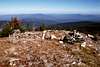
Views From The Summit
 |  |  |  |  |
When To Climb
The climbing season is during the summer and fall. Winter climbing is difficult because access routes are not seasonally maintained. To get there in the winter will require well planned snowmobile and snowshoe excursions.Red Tape
Standard wilderness regulations apply.Mountain Conditions
The Nez Perce National Forest office in Grangeville can provide information about the conditions of the high Gospels and the seasonal road access. Call (208) 983-1950.NOAA Forcast