
|
|
Mountain/Rock |
|---|---|
|
|
45.80798°N / 6.40812°E |
|
|
Haute-Savoie |
|
|
Hiking |
|
|
Spring, Summer, Fall, Winter |
|
|
7904 ft / 2409 m |
|
|
Overview
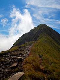
Mont Charvin is located at the Southern end of the Aravis Range. The view on the summit offers an incredible view on the Mont-Blanc range.On the way up, you will have a good chance to see mountain birds such as Gypaètes (vulpture family), very colorful flowers and striking strats of rock due to natural erosion, typical of the Aravis chain.
This mountain can be easily ascended in summer on a obvious trail, or in winter with snowhoes or skies. The slope on the way down is straight forward and can be skied down with no particular danger.
For cliff climbing, you can visit the nearby site : Rocher des Aravis.

Getting There

From Thônes, there are two different roads to take, depending on the ridge (North West or East) you will ascend :
-> Western access (for the North West ridge) :
In Thônes, take road D12 until Serraval (11 kms) then D162 to Le Bouchet (4 kms).
From there, carry on to reach a small place called La Savataz (4 kms).
The road becomes a large trail, you can still drive on (1 km).
It ends at Les Fontanelles. There starts the proper hiking trail.
-> Northern access (for the Eastern ridge) :
In Thônes, take road D12 and after 2 kms take left to reach Manigod (4 kms).
From there drive further East for 8 kms to reach Sous l'Aiguille.
Red Tape
You're free to walk around as long as you don't bother wild and domestic animals. Take your trash away with you.Camping


There are two camp sites in Thônes.
You can everything you need in that little town (food, gasoline etc...)
Camping Le Lachat
La Cour
74230 THONES
Tel : 04 50 02 96 65
Camping Le Trèjeux
Bellossier
74230 Thônes
04 50 02 06 90
Routes to the top
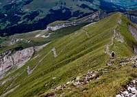
Normal Route (North West ridge) : F
-> 930m ascent / 3h up + 2h down / easy trail
-> No equipment required, just good hiking shoes
Arête du Lac (East Ridge) : PD-
-> 1240m ascent / 5h up + 2h30 down / easy trail up to the lake then ridge that requires a few climbing skills (II) and no fear of vertigo.
-> via ferrata equipment can be useful for the ridge part, as cables are there to help you.
Book, Map & Weather
The best Hiking Guidebook : Randonnées sur les sommets de Hautes-SavoieThe best map : Megeve / Col des Aravis (IGN 3531OT)
And for weather forecast : Meteo France
