La montagna chiama i suoi figli, ed essi rispondono fedelmente al suo appello…
Osvaldo Cardellina, Diario alpinistico, 1964-65
Page texts: @ OsvaldoCardellina"Osva", passed away on May 2, 2022. Page owners: Christian Cardellina e Osvaldo Cardellina. Any updates from September 12, 2022: Antonio Giani, page administrator, friend and climbing companion.
Testi della pagina: @ OsvaldoCardellina "Osva", scomparso il 2 maggio 2022. Proprietari pagina:Christian Cardellina e Osvaldo Cardellina. Eventuali aggiornamenti dal 12 settembre 2022: Antonio Giani, amministratore della pagina, amico e compagno di salite.
Normal & Standard Overview
The Mont Velan is in the Pennine Alps, just to the Southwest of the Group of Combins and then placed on the border between Italy and Switzerland. Mountain quite complex, is formed by five sides, two of which are addressed to each of the two nations (pratically three for the Swiss, because the North is divided in two by another Northeast Ridge). In this paper, the primary objective is to identify the way most currently used on each of these, making a distinction somewhat "artificial" between Via Normal and Via Standard. For the first means the one which can be stated as the easiest path to follow, which is not always coincides with the fact that it is. Many factors have influenced these changes and Velan is not exempt. As has happened to many mountains the Way of the first climbers of a mountain has been changed and abandoned in time (from Mont Blanc to reach the Matterhorn) for various reasons, not least the danger connected to falling ice, seracs, stones if not even landslides, as well as to changes in glaciers and their crevasses (see the attack to Eastern Ridge or Normal towards the Aig. de Talèfre or the path on the Tribulation Glacier Gran Paradiso. So what was the Normal Route of the past is gone into disuse or simply changed the route. For this reason we prefer to speak of "Via Standard" that corresponds to the one currently most used and therefore frequented by differentiating it from the one that may be considered "Normal Route", but not more frequented or infrequently. Each of these four sides ( the fifth or North, bisected by the North-Northeast, is to exclude a priori, as it has only routes of considerable difficulty) offers this ambivalence, for something we analyze the same on both the Italian and Swiss sides out following a time from the almost common trail that crosses through the Valsorey Glacier passing near the hill of the same name (3.107m). Then we go back for a moment on these old-growth and glorious footsteps, marking a particularly historic Mont Velan or V'lan.
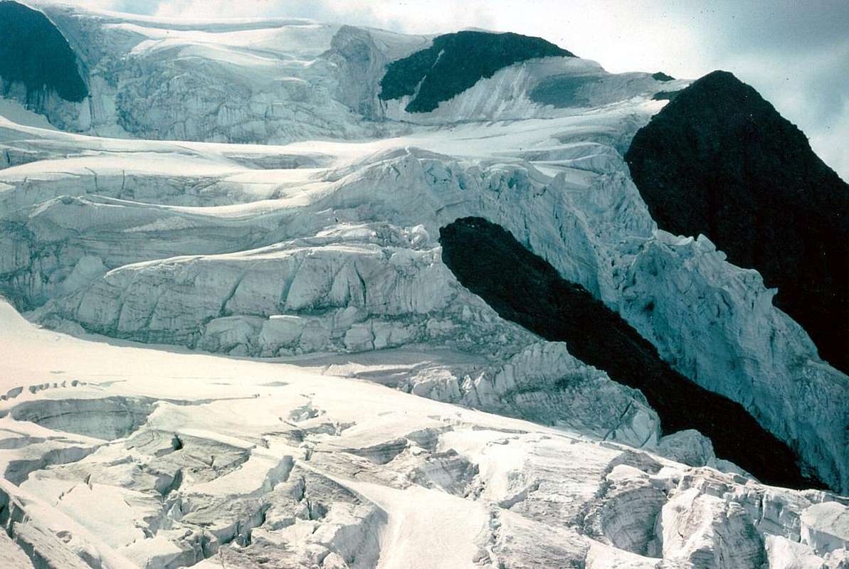
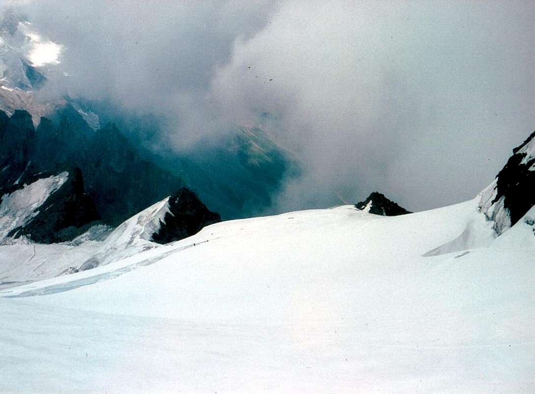
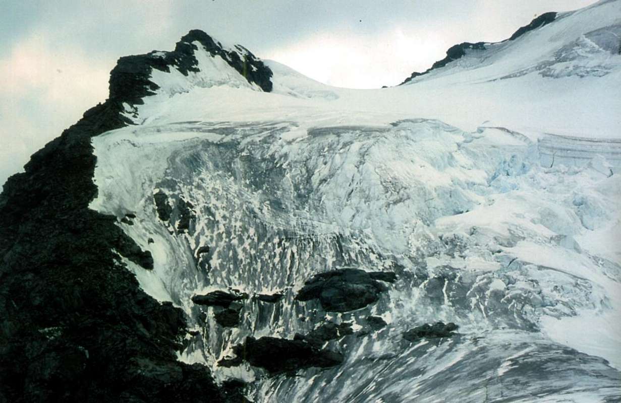
Descending on final part of Northeast Ridge or Italian Standard Route above Valsorey Pass, by Osw
Il Mont Velan si trova nelle Alpi Pennine, subito a Sudovest del Gruppo dei Grands Combins e quindi posizionato sul confine tra Italia e Svizzera. Montagna alquanto complessa, é formata da cinque versanti dei quali due sono rivolti ad ognuna delle due nazioni (in pratica tre per lo svizzero, poiché il Sttentrionale si divide in due parti delle quali una a Nord sul Glacier de Tseudet e l'altra ad Est-nordest sopra quello notevolmente più esteso di Valsorey). In questo lavoro l'obiettivo primario consiste nell'individuare la via attualmente più utilizzata su di ognuno di questi, effettuando una distinzione un poco "artificiosa" tra Via Normale e Via Standard. Per la prima si intende quello che può essere indicato come il percorso più facile da seguire, cosa che non sempre coincide con il fatto che lo sia. Molti fattori hanno influito su questi cambiamenti ed il Velan non ne é esente. Come é successo per molte montagne la Via dei primi salitori di una montagna é stata cambiata ed abbandonata nel tempo (a partire dal Monte Bianco per arrivare al Cervino) per vari motivi, non ultima la pericolosità connessa a possibili cadute di ghiaccio, seracchi, pietre se non addirittura frane, nonché al mutamento dei ghiacciai e dei loro crepacci (vedi attacco al Talèfre od il percorso del Ghiacciaio della Tribolazione al Gran Paradiso). Quindi quella che era la Normale d'una volta é andata in disuso oppure semplicemente variata nel percorso. Per questo motivo preferiamo di parlare di "Via Standard" che corrisponde a quella attualmente più utilizzata e quindi frequentata, differenziando la medesima da quella che può essere considerata "Via Normale", ma non più frequentata o di rado. Ognuno di questi quattro versanti (il quinto o Settentrionale é da escludere a priori, poiché presenta soltanto vie di notevole difficoltà) offre questa ambivalenza, perlaqualcosa andiamo ad analizzare le medesime sia sul lato italiano che sui due versanti svizzeri seguendo un criterio orario a partire dalla via quasi comune che transita attraverso il Glacier de Valsorey passando nei pressi dell'omonimo colle (3.107 m).
Torniamo quindi per un momento sopra queste vetuste nonché gloriose orme, che segnano un momento particolarmente storico del Mont Velan o V'lan.
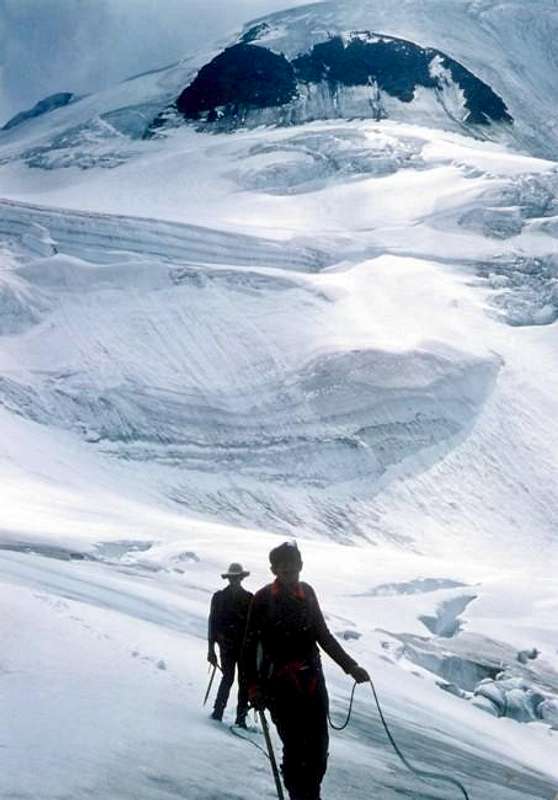
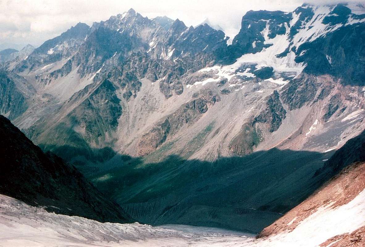
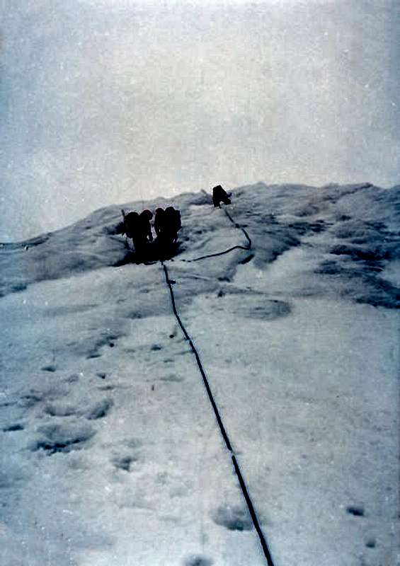
From V'lan Ice Cap (3.734m) towards Valsorey Pass (3.107m), by "Faustin" Savoye, Marco Cossard "Crevassino" & Osw
Little Box Topographic & Mountaineering
To give a better idea let's take a small Resumé Topographic the V'lan. The Mont Velan presents five specific fronts, of which its in Italy and three in Switzerland. The same are mutually separated by the same number of ridges in a clockwise direction so that we can summarize:
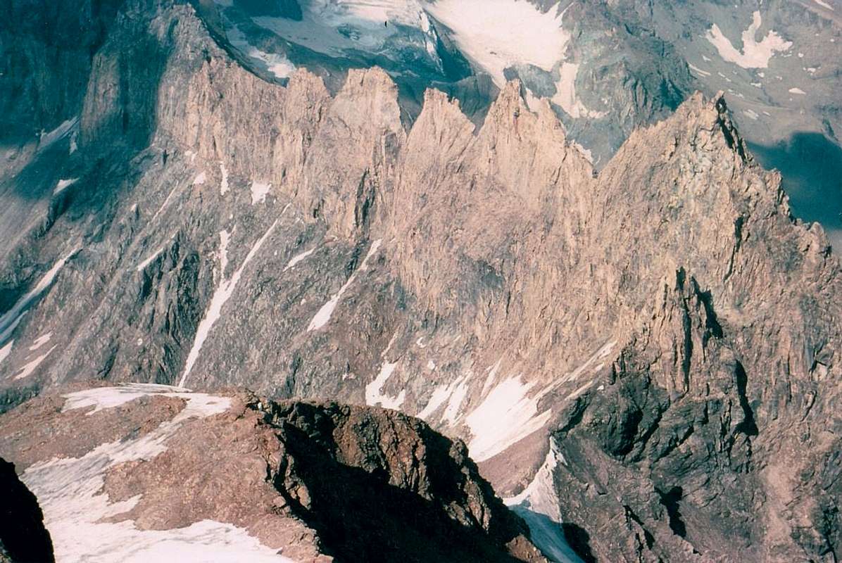
a) - Northeast Ridge by Col Valsorey, between the By Basin and the Valley of Valsorey. Is the Italian Normal and Standard Route. With the South Ridge contains the great Wall-E SE of Velan, that, in its Western margin under the Teeths of Velan (3.595m) and the Horns of Velan (East 3.618 meters, 3.620 meters to West), respectively it reaches 1.100 and over 900 meters high. All of this extensive area stretching to the West-southwest of Valsorey Col (3.107m), above the Bivouac Cristina Rosazza/Savoie (2.774m) at Col de Boègno Bà or Bas, until Saddle Faceballa (3.280m) no has neither Normals and nor Standards. The only acquaintances were in fact the result of individual personal explorations and ascents are really not recommended because of the high danger both in gullies that on large ridges formed by rock often broken and march, though on its extreme Western margin has been realized in 1904 the first winter of the mountain by the Couloirs E-SE of Faceballa Saddle and South below Quota 3.650 meters/Western Horn. b) - South Crest from Pass and Saddle Faceballa, stands between Basin By (East) and the Italian Vallons Menouve Molline. Entirely Italian, originates along the South Buttress to Mont Saron (Municipality of Allein). Divide the wall E-SE from the SW over the Glacier du Mont Velan. In this area there are no Normal or Standard Routes; although the first winter ascent was made in December 1904 through the gully E-SE of the Saddle Faceballa and the higher part of the South Couloir it is a way practically fall into oblivion.
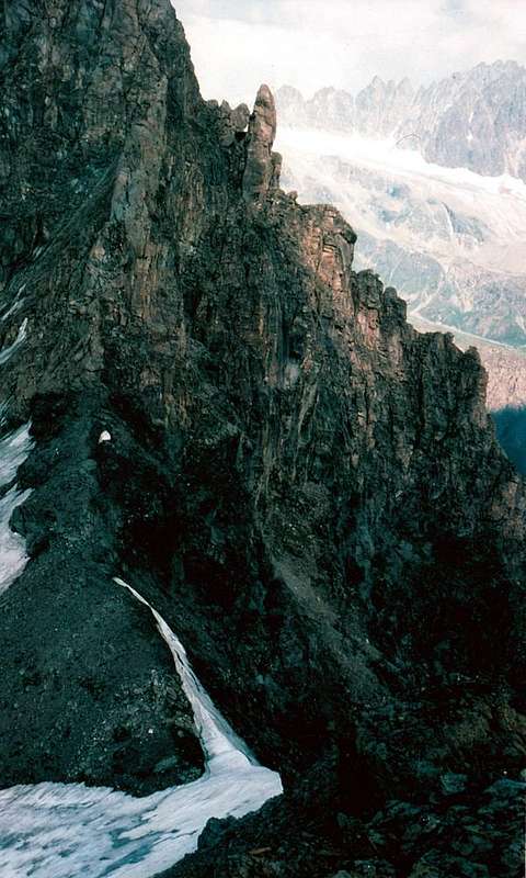
North-northwestern Ridge (left), Western Face & "Hannibal Crest", by Osw
c) - West Ridge or "Hannibal Crest" in the Higher Vallon Molline and that of Proz (Entremont Valley). Is the Western divider toward the Great St Bernard Hill. Moreover separates the SW from the Western Face, which stretches to the Dents de Proz, near which it splits sending a shorter branch towards the Dents. On the first climbing a Via Ski-Mountaineering Italian used to be not so long and that, combined with this by Cabane du Velan, allows the crossing of Velan in this discipline. By contrast the old routes of 1872 (Leaf-Baumann, Guide Bich) downhill and uphill 1902 (Ferrari-Garrone, Guide Meynet) have completely been abandoned because of their exposure to the hazard of falling stones and even small landslides although through the first had met a good attendance. That of 1901 (Balley father and son with Cibrario-Viale) is not been repeated and immediately right passes that by Ski-Mountaineering. On Wall West, right margin, was made the first ascent of the absolute Velan (Mourith-Genoud, 1779) but this route has been completely abandoned, while in the adjacent gully (the left-most of the "Couloir Y" of the Swiss rope Years '70) of monks of St. Bernard is rarely traveled despite being always dangerous. Surely preferable to the West Ridge from the Pass of Hannibal, easier to reach on the Italian side not by the Swiss, despite its brevity. Can be considered a Normal, but not Standard because of low attendance, remains a Historical Via (D'Allèves-Marquis 1826, Cibrario 1891, both roped downhill, uphill Balley 1901, Bobba 1892).
North-northwestern Ridge (right) & Northern Walls, by om
d) - Northwest Ridge riding Glacier de Proz (Northwest) and Glacier de Tseudet (North-northeast), both in Switzerland, Val d'Entremont and Valsorey. It originates from Petit Velan in the direction of the Dents de Proz and Aig. du Velan. Very scenic ascent unjustly not very busy because the rock is not always good, up to the Petit Velan (3.223m) divides the Western Faces of the Petit Velan, Dents de Proz, Aiguille du Velan and Quota 3.670 meters from the Quota 3.672 meters above the glacial, steep North Walls. e) - Crest Northeast completely in Switzerland between Glaciers Tseudet and Valsorey (East-Southeast); not to be confused with the first Northeast boundary. Goes up from the Mont (3.212m) and Col de la Gouille reaching , after the Arête de la Gouille (3.252m, 3.421m), the Quotas 3.580, 3.500, 3.622 meters before the Ice Cap of the Summit (3.734m) and containing in East the vertiginous North Wall. It forms the Western edge of the Glacier de Valsorey on which pass both ways Normal (completely via to the Glacier Valsorey or 1826 Route) and Standard (from Cabane du Velan on the Glacier de Tseudet, crossing Col de la Gouille and Glacier de Valsorey) by Switzerland. This ridge, climbing 3th September 1872 by H.J. and Walter Leaf Guide Swiss Hans Baumann and Daniel Bich Valtournanche, presents a fascinating journey and quite easy on the ridge between the two glaciers. Little known until the construction of Velan Cabane in 1945 (2.569m), knows today a good number of climbs thanks to the proximity of the same. It also allows to be made anough easily even downhill, although generally the return takes place by means of the Standard Route on the Valsorey Glacier and via the Col de la Gouille (3.149m).
Much better to take a look all around and better & better see the Map, by Marco Cossard, "Faustin" Savoye, Maria grazia Schiapparelli & Osw
Per dare un'idea più precisa diamo un piccolo Resumé Topografico del V'lan. Il Mont Velan presenta cinque specifici versanti, dei quali sue in Italia e tre in Svizzera. I medesimi sono tra loro separati da altrettante creste che in senso orario così possiamo riassumere: a) - Cresta Nordest dal Col di Valsorey e sita tra la Conca di By e la Valle di Valsorey. Si tratta sia della Normale che Standard Via dall'Italia. Con la Cresta Sud contiene la grande Parete E-SE del Velan che, nel suo margine Occidentale sotto i Denti del Velan (3.595 m) ed i Corni del Velan (Est 3.618 metri circa, 3.620 metri quello Ovest), raggiunge rispettivamente i 1.100 ed oltre 900 metri di altezza. Tutto questo esteso settore che si allunga verso Ovest-sudovest dal Col di Valsorey (3.107 m), sopra il Bivacco Cristina Rosazza/Savoie (2.774 m) presso il Col de Boègno Bà o Bas, fino alla Sella di Faceballa (3.280 m) non possiede né Vie Normali e tantomeno Standard. Le uniche frequentazioni son state infatti frutto di singole esplorazioni personali e l'ascensioni son veramente sconsigliate per l'elevata pericolosità sia nei canaloni che sui crestoni formati da roccia spesso rotta e marcia, anche se sul suo margine estremo é stata realizzata nel 1904 la prima invernale coi Couloirs E-SE della Sella e Sud Quota (3.650 m)/Corno Ovest. b) - Cresta Sud dal Colle e Sella di Faceballa, collocata tra la Conca di By (Est) ed i Valloni di Menouve e Molline. Interamente italiana, origina il lungo Contrafforte Meridionale sino al Mont Saron (Allein). Divide la Parete E-SE da quella SO sopra il Glacier du Mont Velan. In questo settore non esistono vie né Normali, né Standard; anche se la prima invernale assoluta è stata effettuata nel Dicembre 1904 tramite il canalone E-SE della Sella di Faceballa e la parte superiore del Couloir Sud risulta via caduta nel dimenticatoio.
N-NW Ridge (left), W Face and Crest, SW Face & S Crest from Saddle, by Osw
c) -Cresta Ovest o meglio conosciuta quale "Cresta di Annibale" tra il Vallone di Molline (Italia) e quello di Proz (Val d'Entremont). Costituisce il termine dell'esteso divisorio Occidentale verso il Colle del Gran San Bernardo. Inoltre separa la Parete SO da quella Occidentale, allunganesi fino ai Dents de Proz. Sulla prima sale una Sci-Alpinistica italiana utilizzata da non molto tempo e che, abbinata con quella dalla Cabane du Velan, consente la traversata del Velan in questa disciplina. Per contro le vecchie vie del 1872 (Leaf-Baumann, Guida Bich)in discesa e 1902 in salita (Ferrari-Garrone, Guida Meynet) sono giustamente completamente abbandonate a causa della loro pericolosità per l'esposizione a cadute di pietre ed anche piccole frane, anche se la prima aveva conosciuto discreta frequentazione. Quella del 1901 (Daniel Balley padre e figlioDaniel con gli alpinisti piemontesi Cibrario-Viale) non é più stata ripetuta e subito a destra passa la Sci-Alpinistica. Sulla adiacente, ma ormai interamente in territorio svizzero sopra il minuscolo Glacier de Proz, Parete Ovest, margine di destra più rivolto ad Ovest-nordovest, è avvenuta la prima ascensione assoluta del Velan (Mourith-Genoud, 1779) ma questa via é stata totalmente abbandonata, mentre quella adiacente nel canalone (ancora più a sinistra o Nord di quello ad "Y" degli Svizzeri fine Anni '70) dei Monaci del San Bernardo viene raramente percorsa pur risultando sempre pericolosa. Preferibile sicuramente la Cresta Ovest dal Colle di Annibale, più facile da raggiungere sul versante italiano che non dallo svizzero, anche se tramite breve tratto. Può essere considerata una Normale, ma non una Via Standard a causa della bassa frequentazione, rimane comunque una Via Storica (D'Allèves-Marquis 1826 e Cibrario 1891, entrambe le cordate in discesa, Balley e Compagni 1901 in parte in salita nel tratto finale e Bobba 1892, in totale salita dal colle). d) - Cresta Nordovest a cavallo dei Ghiacciai di Proz (Ovest) e Tseudet, entrambi in Svizzera. Si origina dal Petit Velan in direzione dei Dents de Proz e dell'Aiguille du Velan, nei pressi della quale si sdoppia inviando un ramo più corto verso i Dents. Panoramica ed ingiustamente non molto percorsa, divide sin dal Petit Velan la Parete Ovest da quella Nord.
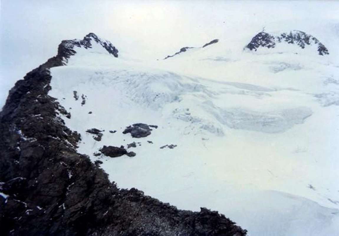
More internal NE Ridge (right) between Tseudet and Valsorey Glaciers, by Osw
XCVe) -Cresta Nordest completamente in Svizzera tra i Ghiacciai di Tseudet (Nord-nordest) e Valsorey (Est-sudest); da non confondersi con la prima Cresta Nordest di confine dal Col di Valsorey. Sale dal Mont (3.212 m) e Col de la Gouille raggiungendo, dopo l'Arête de la Gouille (3.252 m, 3.421 m), le Quote 3.580, 3.500, 3.622 metri prima di raggiungere la Calotta Ghiacciata della Vetta (3.734 m) e contenendo ad Oriente la vertiginosa Parete Settentrionale sopra il Glacier de Tseudet e la Cabane du Velan (2569 m). Costituisce il margine Occidentale del Glacier de Valsorey sul quale transitano entrambe le vie Normale (completamente per il Ghiacciaio di Valsorey o Via del 1826) e Standard (dalla Cabane du Velan per il Glacier de Tseudet, Col de la Gouille e Glacier de Valsorey) dalla Svizzera. Questa cresta, salita il 3 Settembre 1872 da parte di H.J. e Walter Leaf con la Guida svizzera Hans Baumann e Daniele Bich di valtournanche, presenta un percorso panoramicamente suggestivo ed abbastanza facile sulla cresta spartiacque tra i due ghiacciai. Poco frequentata fino alla costruzione della Cabane du Velan (1945), conosce oggigiorno un buon numero di salite grazie alla vicinanza della medesima. Permette inoltre d'esser percorsa abbastanza agevolmente pur in discesa, anche se generalmente il rientro avviene per mezzo della Via Standard sul Glacier de Valsorey ed il Col de la Gouille (3.149 m).
Swiss mid Standard Route on Valsorey Glacier from Cabane du Velan, by Osw
Getting There
BY CAR:
From TORINO, MILANO, etc: Motorway A5. Exit at IVREA mor Quincinetto (PIEDMONT).
From IVREA Town: before in West to Aosta, after in Northwest to Gignod, Etroubles, Saint-Oyen, Saint Rhémy en Bosses, (Southwestern and Northwestern Sides) and in North to Allein, Doues, Valpelline Municipalities.
From Courmayeur Resort: before in East to Aosta, after in Northwest to Gignod and in North to Allain, Doues, Valpelline and Ollomont Municipalities.
From Aosta Town to Allein and Doues Common in By Basin
FromAosta City towards Variney Fraction and Gignod Commune(988m) with Great Saint Bernard SS.27 up to the alternative 1.074 meters, just before Condemine Hamlet (1.137m). Before crossing North the Artanavaz Torrent or Buthier de Bosses after in the Northwest towards Allein Municipality; from the fork 1.253 meters nearby this last, always with the Regional Road in Northeast, towards Doues Commune.
Mont Velan above By Basin, by emilius
From Allain/Doues to Ollomont/Valpelline Communes with By Basin.
FromAllein Commune(1.251m), with Regional and Municipal Roads, to By Basin; from the entrance of this (various alpages reached by private dirt farms roads), through paths, up to the Mont Saron Southern Antesummit (2.681m) and traverse on crest to Tête de la Praz (2.751m) and Crou de Bleintse (2.824m).
From Doues Commune(1.176m), with in asphalt Municipal Road, to By Basin; from this, with paths or dirt roads, to Mont Saron (2.681m), Crou de Bleintse (2.824m), Letey Refuge below Champillon Pass (2.430m), Mont Chenaille two Summits (3.144m), Tsa d'Ansermin (2.388m) and Monte Rotondo (2.572m).
FromOllomont Commune(.1356m), trhough noumerous paths and various upper private dirt farms roads, towards the By Conca; from this numerous routes in all directions up to the Maria Cristina Rosazza at Savoie Bivouac (2.674m), nearby the Bégno Bà or Bas Hill.
V'lan by Gr. Tête de By, by archiloco
From Aosta Town to Ollomont Common in the homonym Valley.
From Aosta City towards Variney Fraction up to the alternative 786 meters (Savin Hamlet); continue North with the Regional Road towards Moulins between the two Torrents Rio Artanavaz also called Buthier de Bosses and Buthier de Valpelline, Rhins, Collin, Creusevy, Chanodaz, Liarey, Fabrique, Chez-les-Chuc Villages reaching in the Northeast Valpelline-Les Ansermins Municipality (996m). At the subsequent crossroads 1.059 meters (Chez-Cailleur Hamlet) turn left (North-northwest) reaching Chez-Collet, Clapet, Vesey Villages and Ollomont-Cognen Common (1.356m); continue North along the Buthier d'Ollomont towards Rey, Vaud, Glacier or Glassier(1.562m) Villages. From this towards the Refuge Franco Chiarella-Amiante (2.979m), Filon Alp (2478m), Bonne Mort Pass (2.646m), Fenêtre Durand Hill (2.797m), Nino Regondi Bivouac (2.599m) and Lakes, Tsa de Berrio Alp (2.165m), Cormet Hill (2.354m) and Breuson Hill (2.194m). From Orsières Town (879m) towards the Val d'Entremont and Valsorey.
Orsières to Fontaine Dessous-Rive Haute (1.223m), Liddes (1.346m) and Bourg St. Pierre (1.346m) in Entremont Valley and at the beginning of Valsorey to the Southeast.
From Great Saint Bernard Hill (2473m) towards the Val d'Entremont and Valsorey From Great Saint bernard Pass, by the Swiss State Road, with descent towards Le Tronchet, Plan des Dames, Hospitalet (2.113m), Bourg Saint Bernard (1.927m) up to Bourg Saint Pierre and previous route.
From FRANCE: through the Mont Blanc Tunnel to Entrèves-crossroads to Vény/Ferret Valleys - Mountain Guides of Courmayeur - La Saxe Rock Gym - Courmayeur. By Little Saint Bernard Pass, closed since November until half May to La Thuile Valley - Pré Saint Didier - Courmayeur.It is not necessary to take Motorway A5: you can drive on SS.26, in the direction of AOSTA - IVREA - TURIN.
BY PLANE:
Aeroporto "Corrado Gex" Saint Christophe (Aosta).
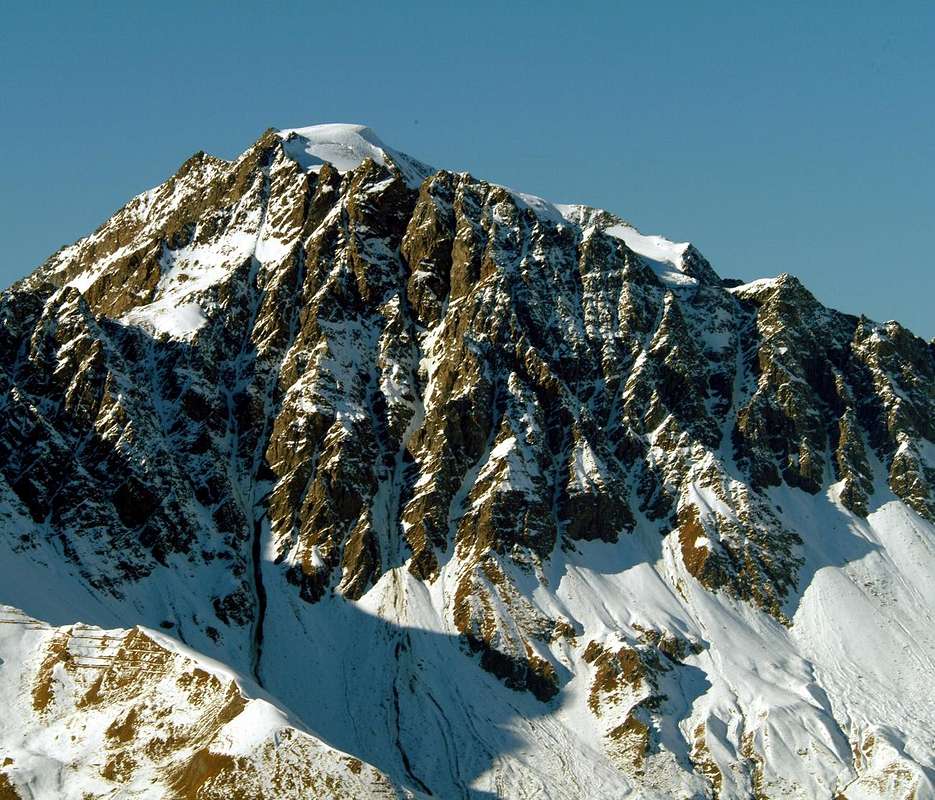
Mont Velan from Northeast, by buxlex
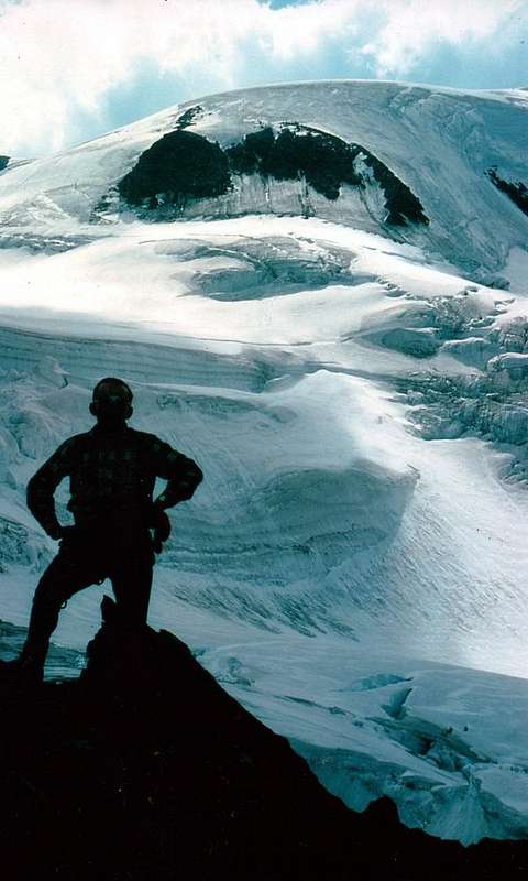
Standard Approaches & Normal Routes
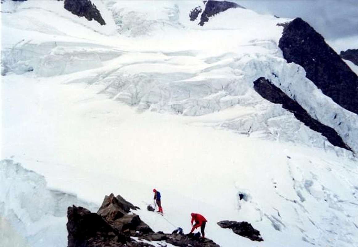
Just above the connection Italian/Swiss Standard Routes from Bivouac Rosazza Savoie & Velan Hut, Picture by Osw
Approaches with relative Routes
NOTE: The two-way Italian and Swiss customarily used have a common part in the "higher" on the Glacier de Valsorey, but are completely different in approach (logically) as well as at the bottom and in the middle where they meet to about 3.240/50 meters, after crossing the Mont Cordine (3.329m) or higher in the North of the Horns of Velan (East 3.618m, 3.620m West) at an altitude of 3.580/90 meters around. But typically both are covered individually and the connection, if anything, happens at the top at the Horns of Velan.
Italian way through the Col de Valsorey, the Northeast Ridge and the Glacier de Valsorey
From Bivouac Rosazza Savoie at Col du Boégno Bà (2.674m): from the bivouac, accessible from Glacier or Glassier Hamlet (1.562m) with path n° 3 passing through the Alps of Cheval Blanc (1.962m), Porchère, Tsa Porchère (2.290m) and Dos de Boégno Bà (E; 2h'45/3h'15). From the Bivouac Cristina Rosazza at Savoie and from the neighbor of Boegno Bas Pass (2.674m) to address him toward Northeast along a trace that with a long diagonal in "light" ascent, overcoming some small vallons in grass and debris, it brings him in direction of a small torrent that comes out of an area of large boulders in the midst of which you have to find the traces of the passage. Exceeded the same, leave the bottom of the valley and climb to the left (West) up the steep scree slope that leads to the Valsorey Pass (3.107m), located between the Mont Cordine (more precisely "Plateau de Cordine") and Trois Frères (Three Brothers). On a track, which often disappears, go up in the direction of achieving the same end of a broken route and debris immediately to his left; overcome it, taking care not to drop the stones on those who follow. Once up the hill to the right cross in the same direction, passing some small balconies with easy but exposed rocks; the frame of the hill, in general, it always passes to the left against the start of the Northeast Ridge Mont Cordine. From the pass you do not continue with this, but, leaning to the right on a clear track, climb through the shattered Northeast Slope; progressively move, always following the trail on the ridge, reaching a shoulder snow at an altitude of 3.221 meters, called "Plateau de Cordine". Leaving on a rocky spur that goes right up to plunge into the glacier through broken rocks and debris, but easily reach the Top (3.329m; EEA/F+/PD-; 2h'15/2h'30). From Mont Cordine down quite easily to the underlying very narrow Col des Chamois (3.259m) and, bypassing the right Doigt du Velan (3.314m) surpass even the next Mont Capucin (3.395m) to reach the hill of the same name (3.376m; EE/F+; 1h'30/ 2h'00 Col Valsorey). Continue now definitely on the edge of the glacier and rocks of the Testa (Head) of Ariondet passing a steep section of about 40-50 meters, requiring caution often being covered by "verglass phenomena" (from 40° to 50°, delicate step) and we land so to the top, where it comes with more route right (North), and the way the hut Velan that comes from Col de la Gouille (3.149m). A long, easy and not too steep diagonal to arrive at the Northwest Quota 3.672 meters beyond which you will reach the vertex of the Summit Ice Cap (3.734m; A/PD-/F+; 1h'10/1h'20 Col du Capucin; 3h'15/3h'45 Col Valsorey. Very variable depending conditions of serac near T. d'Ariondet).
Immediately after Mont Cordine just above Valsorey Pass, by Osw"
1) - Variant 1912 avoids the climb to Col Valsorey prejudice about 150 meters West of the same rocks and reaching through very broken and a rocky groove from right to left with debris and rock material in the balance. This way implemented by the Abbé Joseph Marie Henry with Mountain Guide Théodule Forclaz September 26th, 1912 leads halfway between Col Valsorey and the "Plateau de Cordine" (3.221m). Would not recommend, because what little spare time does not justify the risk of dangerous falling stones.
2) - Ancient Variant: from the "Plateau de Cordine" not rise above the first rocky promontory (see next variant), but down easily (28°/30°) on the Glacier de Valsorey behind this shoulder. A rather intricate crevices obstructs the road to reach the base of Mont Cordine North, whence the Via Standard. Perhaps for the progressive mutation of the state of the glacier, this road is completely fallen into disuse presenting more risks and dangers (for fall of stones) that no effective saving of time. It is mentioned here to exclusive historical title and in any case is rather dangerous and therefore not advisable; also most likely no longer viable, because of the chaotic and unpredictable crevasses disposition.
3) - Current Variant: without reaching from the "Plateau de Cordine" the Mont Cordine, down from the first rocky shoulder in easy diagonal right to the left (Northwest) on the glacial pretty little steep slope (34°/37°) and rounding to the right the Northwest Spur to reach the Col des Chamois whence the previous route. Not always advisable if the slope is frozen or crevasses behind to force a search of the passage with relative waste of time (A/F+; 0h'20 in less, in very good condition). Evaluate by high very carefully, otherwise normally bypass the nearby Mont Cordine with relative descent on Chamois Pass through the little Northwestern Eperon. The thread of the edge on the West-southwestern Ridge towards the Col des Chamois is less praticable, because formed by steep and rotten rocks South-facing; or which reason it is really quite unwise.
4) - Variant of 1975: in integral descent through the entire Northeast Ridge: this route is being built by Osvaldo Cardellina, Marco Cossard, Camillo Roberto Ferronato, Giuseppe Lamazzi and Robero Meneghini 17th August 1975 with complete descent to the Northeast Ridge from Ice Cap, Velan Horns and Jags, Testa d'Ariondet, Mont Capucin and Mont Cordine towards Col de Valsorey (3.107m). This variant is actually a completely different route allowing you to reach the Summit without hardly ever touch the glacier if not at the end of the altitude 3.672 meters to the ice Cap. Very useful, even if it requires more time and effort, in bad conditions the Glacier de Valsorey, especially in the steep section just North of the Head of Ariondet. In this case we have no doubt about the choice of the way and fall back on the crest of the border at least until the plateau above the head and then go back on the Standard. This part of the ridge is quite easy and requires only a bit of research of the via between rocks in large blocks, with a bit exposure to the South.
5) - Variant "Low" connection from the base to the North of Mont Cordine towards the middle Via Switzerland crossing Valsorey Glacier : in bad conditions ("verglass") of the serac just North of the Testa (Head) of Ariondet is also possible, without decline, as mentioned above, on the border ridge rejoin the Swiss Route with a descent to the Northwest through the Glacier de Valsorey. From the base of the small Spur Northwest Mont Cordine reach the base of the islet where the goes up away from Cabane du Velan; in this way, losing one hundred metres in false level route you connect to this last to altitude 3.240/50 meters around. This "trick" allows to avoid the climb the serac but not always easy path and a lot depends on the situation of the crevasses in the crossing from the Eastern to the Western edge of the Glacier de Valsorey. It can be an alternative to reach Italy (Rosazza Bivouac at Savoie nearby Col de Boégno Bà in Basin By) Cabane du Velan crossing the Col de la Gouille, but probably not worth the candle (A/PD; 0h'30/0h'45 for the connection from the Northern base of Mont Cordine; A/PD; 1h'30/1h'45 from hill to hill; A/PD-/PD/PD-; 3h'30/4h'00 from hut to hut).
Crux icy step on Standard immediately after Mont Cordine,
by Marco Cossard "Crevassino"
Swiss Route from Velan Hut and through the Col de la Gouille and the Glacier de Valsorey
From Cabane du Velan (2.569m; 60 beds and inaugurated in 1945 by the Geneva Chamber CAS), located on the lateral moraine of the left (West) of the Glacier de Tseudet and accessible by good path from Bourg Saint Pierre (1.632m) in the Valley Entremont and subsequent deviation in Valsorey through the path that leads to the Cabane de Valsorey until the deviation below the Chalets d'Amont (2.198m), after fording the Torrent de Tseudet you reach the locality "Lui des Bourres". Passed the fairly steep grassy stretch, through several hairpin bends, you will reach the lateral moraine and the nearby Cabane. From this head to Southeast reaching glacier following the water intake and then down to the most convenient; first follow the same on its western edge below the Petit Velan. Later, after passing an area with many cprepacci, through progressively towards Southeast towards Mont de la Gouille (3.212m), which is around the right keeping a distance and protected against falling stones. Reach the rounded upper basin linearly heading towards the Col de la Gouille, which can be reached easily on short scree slope leaving left (North) two tiny twins gendarmes (3.149m; A/F+; 1h'45/2h'15 from Cabane). The descent on the other side is not as easy and simple although short; surpassed a small wall of broken rocks and covered with debris (equipped with fixed ropes), they follow the red signals that lead, turning South, over the Glacier de Valsorey altitute in 3.020/30 meters around (A/PD/PD-; 0h'30 by Gouille Pass). From here continue with winding path on the glacier on the left, leaving an area with many crevasses and, after reaching the junction with the road that descends from the Col Valsorey, bear right past a rocky islet on your left and discarding right (North) the big serac alongside the Head of Ariondet (crux of the Italian Via) until you reach the upper plateau to the North of the Horns of Velan in altitude of 3.580/90 meters about, where comes the road from Valsorey Pass and with this last conclusion (A/PD-/PD; 2h'45/3h'15 Col de la Gouille; 5h'00/5h'30 by hut).
Historical versions of 1826 and 1891: already in 1826 the Monks of the Great Saint Bernard D'Allèves and Marquis had deviated against the crest of border at the top of the trail, coming directly from Valsorey through eponymous Glacier. This journey through time was increasingly abandoned, especially after the inauguration in 1945, by the Geneva Section of the CAS, of the Cabane du Velan (2.569m, two-storey building in stone, always kept open but only in summer) on the lateral moraine Glacier de Tseudet, under the Mont V'lan North Wall. The part more in bottom was ascended instead by the British O.G. Jones and C.G. Monro together with Swiss Mountain Guides Antoine Bovier and Pierre Gaspoz the September 8th, 1891, which from the Col des Chamois had climbed the Northeast Ridge of Mont Capucin and then continue lowering along the Glacier de Valsorey.
On plateau over the crux passage, Picture by Osw
Avvicinamenti e Vie relative
NOTA: Le due vie italiana e svizzera abitualmente usate possiedono una parte in comune nella parte "più elevata" sul Glacier de Valsorey, ma risultano completamente differenziate nell'avvicinamento (logicamente) nonché nella parte inferiore ed in quella media, dove si riuniscono a circa 3.240/50 metri, dopo avere oltrepassato il Mont Cordine (3.329 m), oppure più in alto a Nord dei Corni del Velan (Est 3.618 m, 3.620 m Ovest) a quota 3.580/90 metri circa. Però in genere entrambe vengono percorse autonomamente.
Via italiana tramite il Col de Valsorey, la Cresta Nordest ed il Glacier de Valsorey
Dal Bivacco Rosazza Savoie al Col du Boégno Bà (2.674 m): dal bivacco, raggiungibile da Glacier o Glassier (1.562 m) con sentiero n° 3 che passa per le Alpi di Cheval Blanc (1.962 m), Porchère (2.102 m), Tsa Porchère ed il Dos de Boégno Bà (E; 2h'45/3h'15). Dal Bivacco Cristina Rosazza al Savoie e dal vicino Col du Boégno Bà (2674 m) indirizzarsi a Nordovest lungo una traccia che con un lungo diagonale in leggera salita, superando alcuni valloncelli in erba e detriti, si porta in direzione d'un torrentello fuoriuscente da una zona di grandi massi in mezzo ai quali bisogna trovar le tracce di passaggio; oltrepassati i medesimi, abbandonare il fondo del vallone e salire più verso sinistra (Ovest) il ripido pendio detritico che conduce verso il Colle di Valsorey (3.107 m), posto tra il Mont Cordine ed i Tre Fratelli. Su d'una traccia, che spesso tende a scomparire, salire in direzione del medesimo raggiungendo una fascia di rotte rotte e detritiche subito sulla sua sinistra; superarla facendo attenzione a non far cadere delle pietre sopra chi segue. Arrivati all'altezza del colle attraversare verso destra in direzione dello stesso passando alcuni piccoli balconi con rocce facili ma esposte; la cornice del colle, in genere, la si supera sempre a sinistra contro l'inizio della Cresta Nordest del Cordine. Dal colle non si continua tramite questa, bensì, appoggiando a destra su d'una evidente traccia, si sale per mezzo del frantumato Versante Nordest; progressivamente portarsi, sempre seguendo le tracce, sulla cresta raggiungendo una spalla innevata a quota 3.221 metri, detta "Plateau de Cordine". Lasciando sulla destra uno sperone roccioso che scende fino ad immergersi nel ghiacciaio, tramite rocce rotte e detrito, ma con percorso facile, raggiungere la Cima (3.329 m; EEA; F+/PD-; 2h'15/2h'30). Dal Mont Cordine scendere abbastanza facilmente al sottostante e stretto Col des Chamois (3.259 m) ed, aggirando sulla destra il Doigt du Velan (3.314 m) sorpassare anche il successivo Mont Capucin (3.395 m) raggiungendo l'omonimo colle (3.376 m; EE/F+; 1h'30/2h'00 dal Col di Valsorey). Continuare ormai decisamente sul margine tra il ghiacciaio e le rocce della Testa di Ariondet superando un tratto ripido di circa 40/50 metri, che richiede cautela essendo spesso ricoperto da ""verglass" (da 40° a 50°, delicato); si approda così alla parte superiore, dove arriva con itinerario maggiormente a destra (Nord) anche la via dalla Capanna del Velan che proviene dal Col de la Gouille (3.149 m). Un lungo, facile e non troppo ripido diagonale verso Nordovest arriva presso la Quota 3.672 metri oltre la quale si raggiunge il Vertice della Calotta glaciale (3.734 m; A/PD-/F+; 1h'10/1h'20 dal Col du Capucin; 3h'15/3h'45 dal Col di Valsorey. Molto variabile a seconda delle condizioni).
Bad conditions with "verglass" on Standard Via by Valsorey Pass 1976, by Osw
1) -Variante del 1912: permette di evitare la salita da Meridione del Colle di Valsorey, restando circa 150 metri ad Ovest del medesimo e raggiungendo tramite rocce molto rotte ed un canalino da destra verso sinistra con detriti e materiale roccioso in bilico. Questa via attuata dall'Abbé Joseph Henry con la Guida Théodule Forclaz il 26 Settembre 1912 conduce a metà strada tra Col di Valsorey e "Plateau de Cordine" (3.221 m). Sconsigliabile, poichè quel poco tempo risparmiato non giustifica il rischio di caduta di pietre.
2) - Vecchia Variante: dal "Plateau de Cordine" non salire sopra il primo promontorio roccioso (vedi la successiva variante), bensì scendere facilmente (28°/30°) sul Glacier de Valsorey alla base di questa spalla. Una zona piuttosto intricata di crepacci ostacola la strada per giungere alla base Settentrionale del Mont Cordine, donde alla Via Standard. Forse per la mutazione progressiva dello stato del ghiacciaio, questa via é caduta completamente in disuso presentando più rischi e pericoli (anche per la caduta di pietre) che non risparmio effettivo di tempo. Viene quindi qui citata ad esclusivo titolo storico, essendo altrimenti non consigliabile, poiché piuttosto pericolosa e forse non più percorribile.
3) - Variante attuale: senza dover raggiungere il Mont Cordine, scendere invece dalla prima spalla rocciosa in facile diagonale verso sinistra (Nordovest) sul pendio glaciale (34°/37°) e doppiando a destra lo Sperone Nordovest raggiungere in leggera salita il Col des Chamois donde alla precedente via. non sempre consigliabile qualora il pendio risulta ghiacciato od i crepacci alla base costringono ad una ricerca del passaggio con relativa perdita di tempo (A/F+; 0h'20 in meno, in buone condizioni). Da valutarsi con scrupolosa attenzione dall'alto, altrimenti scavalcare normalmente il Mont Cordine scendendo al sottostante Col des Chamois tramite lo Speroncino Nordovest. Il filo della Cresta Ovest-sudovest risulta scarsamente praticabile, poiché costituito da rocce alquanto rotte ed esposte verso Mezzogiorno; per la qual cosa diventa veramente del tutto sconsigliabile.
4) - Variante del 1975: in integrale discesa sulla Cresta Nordest dalla Calotta Sommitale attraverso i Corni e Denti del Velan, Testa d'Ariondet, Mont Capucin e Mont Cordine sino al Col de Valsorey. Questa via é stata realizzata da Osvaldo Cardellina, Marco Cossard, Camillo Roberto Ferronato, Giuseppe Lamazzi e Roberto Meneghini il 17 Agosto 1975. Questa variante in realtà costituisce un itinerario completamente diverso permettendo di raggiungere la Sommità senza quasi mai toccare il ghiacciaio se non nella parte finale dalla Quota 3.672 metri alla calotta. Decisamente utile, anche se richiede più tempo ed impegno, in caso di cattive condizioni del Glacier de Valsorey, soprattutto nel ripido tratto subito a Nord della Testa di Ariondet. In questo caso non avere alcun dubbio sulla scelta della via e ripiegare sulla cresta di confine almeno sino al plateau che precede la Testa per poi tornare sulla Via Standard sul Glacier de Valsorey. Questo tratto di cresta risulta abbastanza facile e richiede esclusivamente un pò di ricerca della via tra rocce a grandi blocchi.
5) - Variante "Bassa" di collegamento dalla base Nord del Mont Cordine alla Via Svizzera: in caso di cattive condizioni ("verglass") del seracco subito a Nord della Testa di Ariondet é altresì possibile, senza declinare, come detto sopra, sulla cresta di confine ricongiungersi alla Via Svizzera con una discesa verso Nordovest attraverso il Glacier de Valsorey. Dalla base dello Sperone Nordovest del Mont Cordine raggiungere la base dello isolotto dove sale la via dalla Cabane du Velan; in questo modo, perdendo un centinaio di metri di dislivello ci si connette a questa ultima a quota 3.240/50 metri circa. Questo "escamotage" permette di evitare la salita del seracco ma non sempre risulta di facile percorso e molto dipende dalla situazione dei crepacci nella traversata dal margine Orientale a quello Occidentale del Glacier de Valsorey. Può essere un'alternativa per raggiungere dall'Italia (Bivacco Rosazza/Savoie al Col de Boégno Bà nella Conca di By) la Cabane du Velan attraversando il Col de la Gouille, ma probabilmente il gioco non vale la candela (A/PD-; 0h'30/0h'45 per il collegamento dalla base Settentrionale del Mont Cordine; A/PD; 1h'30/1h'45 da colle a colle; A/PD-/PD/PD-; 3h'30/4h'00 da rifugio a rifugio).
Via svizzera dalla Cabane du Velan e tramite il Col de la Gouille ed il Glacier de Valsorey
Dalla Cabane du Velan (2.569 m; 60 posti letto e inaugurata nel 1945 dalla Sezione CAS di Ginevra), collocata sulla morena laterale di sinistra (Ovest) del Glacier de Tseudet e raggiungibile con buon sentiero da Bourg Saint Pierre (1.632 m) nella Valle di Entremont e successiva deviazione in Valsorey tramite il sentiero che conduce alla Cabane de Valsorey fino alla deviazione sottostante i Chalets d'Amont (2.198 m), dopo avere guadato il Torrent de Tseudet si raggiunge la località "Lui des Bourres". Superato l'abbastanza ripido tratto erboso, per mezzo di numerosi tornanti, si raggiunge la morena laterale e la vicina Cabane. Da questa dirigersi a Sudest raggiungendo il ghiacciaio seguendo la presa dell'acqua per poi scendere nel punto più comodo; seguire dapprima il medesimo sul suo margine Occidentale al di sotto del Petit Velan. In seguito, superata una zona molto cprepacciata, attraversare progressivamente verso Sudest in direzione del Mont de la Gouille (3.212 m), che si aggira sulla destra tenendosi a debita distanza ed al riparo da eventuali cadute di pietre. Raggiungere il tondeggiante bacino superiore dirigendosi linearmente verso il Col de la Gouille, che si raggiunge facilmente su breve pendio detritico lasciando a sinistra (Nord) due minuscoli gendarmi gemelli (3.149 m; A/F+; 1h'45/2h'15 dalla Cabane). La discesa sul versante opposto é meno facile e semplice, anche se corta; superata una piccola parete di rocce rotte e ricoperta da detrito (attrezzata con corde fisse), si seguono le segnalazioni in rosso che conducono, piegando a Sud, sopra il Glacier de Valsorey a quota 3.020/30 metri circa (A/PD/PD-; 0h'30 dal colle). Da qui continuare con percorso sinuoso sul ghiacciaio lasciando sulla sinistra una zona molti seraccata e, dopo avere raggiunto la confluenza con la via che scende dal Col di Valsorey, piegare a destra oltrepassando un isolotto roccioso sulla sua sinistra e scartando a destra (Nord) il grande seracco a fianco della Testa di Ariondet (punto cruciale della Via Italiana) fino a raggiungere il plateau superiore a Settentrione dei Corni all'altitudine di 3.580/90 metri circa, ove arriva anche la via dal Colle di Valsorey e con questa ultima concludere (A/PD/PD-; 2h'45/3h'15 dal Col de la Gouille; 5h'00/5h'30 dalla Cabane).
Varianti Storiche del 1826 e 1891: già nel 1826 i Monaci del Gran San Bernardo D'Allèves e Marquis avevano deviato contro la cresta di frontiera nella parte superiore del percorso, arrivando direttamente dalla Valsorey tramite il ghiacciaio omonimo. Questo itinerario nel tempo venne sempre di più abbandonato, soprattutto dopo l'inaugurazione nel 1945 da parte della Sezione del CAS di Ginevra della Cabane du Velan (2.569 m; costruzione a due piani in pietra, sempre aperta ma custodita esclusivamente in estate) sulla morena del Glacier de Tseudet, sotto la Parete Nord. La parte inferiore era stata invece percorsa dagli inglesi O.G. Jones e C.G. Monro insieme alle Guide svizzere Antoine Bovier e Pierre Gaspoz lo 8 di Settembre 1891, i quali dal Col des Chamois avevano salito la Cresta Nordest del Mont Capucin per poi proseguire abbassandosi lungo il Glacier de Valsorey.
On terminal part under the Ice Cap (3.734m), Picture by Osw
Ski-mountaineering Via from Etroubles through Menouve/Molline Vallons and Glacier du Mont Velan
From Etroubles Municipality through Menouve Vallon and Molline Bivouac (2.415m): Aosta to go back to the North with the SS.27 of the Gran San Bernardo, after Gignod Commune (994m), reach that of Etroubles (1.280m) to the West out of the same, and after two bends in a Cross, take a detour to the Northeast leading to Prailles Dessous small Village (the Holy Farm "La Grandze in Tsi Inconnu") where, immediately after in the locality Quaye, is placed in the sign ban on driving and where it is obligatory to the parking lot. From the parking Quaye (1.650 meters about) continue through the farms private dirt road, addressing himself to the North, enters and travels along the Menouve Vallon or Menovy passing to the West and high above the Torrent with the same name. Leaving the upper left corner of the Alpages Combe German and Plan Bois (1.893m) the same reaches the next Alp Menovy (1.913m) to the West at the next crossroads abandon the branch that leads to Trecaudette Pastures (2.133m) and continue instead with the lower one to the great Alpage of L'Arvus (1.983m), where the dirt road ends. From this climb with a small path not numbered that goes above the grassy headland coming to a small basin where there are the ruins of an old alp, just below that of Molline Vieille (Old Molline; 2.295m) with a path parallel and in West of the Molline Torrent into the homonymous vallon continue with the path n° 21 reaching the Molline new Bivouac (2.415m; opened since 2005; E; 1h'45/2h'00 by signal no transit), nearby the Mountain Molline. The trail ends here even numbered but continues with smaller and closer and closer to the torrent and then crossing through the path between small vallons and grassy humps reach a crossroads at 2.519 meters. Just before this point, and not long after camp begins the route to the West Slope of the Sella Faceballa, which brings us back to the basic routes of the Southwest Face and its small variations via the above steep South-southwest Ridge, dividing between Low Menouve and Upper Molline Vallon West and the Alp Faceballa to East in the most Western sector of the "Conca" of By (Doues/Ollomont) (E; 0h'20 Molline Bivouac; 2h'10/2h'30 in total).
From Etroubles Common through Menouve/Molline Vallon towards Mont Velan hanging Glacier, by Antonio, sergioenrico with traced by Maria Grazia Schiapparelli
Via Sci-Alpinistica da Etroubles tramite i Valloni di Menouve/Molline ed il Glacier du Mont Velan
Dal Comune di Etroubles tramite i Valloni di Menouve/Molline ed il Bivacco Molline (2.415 m): dalla Città d'Aosta risalire verso Nord con la Strada Nazionale del Gran San Bernardo n° 27 e, dopo il Comune di Gignod (994 m), raggiungere quello di Etroubles (1.280 m). Uscendo verso Ovest dallo stesso, dopo due tornanti e presso una Croce, prendere a Nordest una deviazione che conduce a Prailles Dessous (Agriturismo "La Grandze in Tsi Inconnu") dove, subito dopo in località Quaye, è posizionato in cartello di divieto di transito e dove è obbligatorio effettuare il parcheggio. Dal parcheggio di Quaye (1.650 metri circa) continuare tramite la poderale che, indirizzandosi a Nord, entra e percorre il lungo Vallone di Menouve oppure Menovy passando alta ed ad Ovest sopra l'omonimo Torrent. Lasciando in alto a sinistra le Alpi di Combe German e Plan Bois (1.893 m) la stessa raggiunge il successivo Alpeggio di Menovy (1.913 m); al bivio successivo abbandonare ad Ovest il ramo che conduce all'Alpe Trecaudette (2.133 m) e procedere invece con quello più in basso verso la grande Alpe dell'Arvus (1.983 m), dove la poderale termina. Da questa salire con un sentierino non numerato risalente al soprastante promontorio erboso arrivando ad una piccola conca dove si riscontrano i ruderi d'un alpe antica, appena sottostante quella di Molline Vieille (2.295 m). Con percorso in parallelo ad Ovest del Torrent de Molline continuare nell'omonimo Vallone con il sentiero n° 21 raggiungendo il Bivacco di Molline (2.415 m; aperto dall'estate del 2005; E; 1h'45/2h'00 dal cartello di divieto), presso la Montagna di Molline. Qui termina anche il sentiero numerato proseguendo però con dimensioni più ridotte, quasi una traccia, e, avvicinandosi sempre di più al torrente ed in seguito attraversandolo, tramite il percorso tra valloncelli e gobbe erbose raggiunge un bivio a 2.519 metri. Appena prima di questo punto e non molto tempo dopo il bivacco inizia l'itinerario verso il Versante Ovest della Sella di Faceballa, che ci riconduce agli itinerari di base della Parete Sudovest e relative piccole varianti tramite la soprastante Cresta Sud-sudovest, divisoria tra il Vallone di Menouve/Molline ad Ovest e quello dell'Alpe di Faceballa ad Oriente nel settore più Occidentale della "Conca" di By.
Mont V'lan Southwest & West (left) Faces from West, by Erik Pizzolotto
Finally summarizing
To conclude
By placing a small Resumé we can say that 3 are the Standard Routes and 4 the Ways Normal ones:
Standards Routes
1) - Current italian Via from By Basin, through the Bivouac Rosazza at Savoie, Valsorey Pass, Mont Cordine and Glacier de Valsorey into the middle and upper parts. 2) - Usual Swiss Route from Velan Hutte, Glacier de Tseudet, traverse West/East on Col de la Gouille and Glacier de Valsorey through middle-low and upper parts. 3) - Ski-Mountaineering Via into the Menouve/Molline Vallon from Molline Bivouac, hanging Glacier of Mont Velan, Southwest Slope near the Quota 3.678 meters to Ice Cap.
"Normal" Routes
1) -Historical Routes 1872, 1902 from Menouve/Molline Vallon, through Mollines Alp, South Side Glacier du Mont Velan and West Walls of Quotas 3.708, 3.672 meters to Ice Cap. 2) - Normal by Etroubles, Menouve-Mollines Vallons, Mollines Camp, Pass and Crest of Hnnibal or West Ridge towards Aiguille de Déjeuner and Quota 3.678 meters, Ice Cap 3) -Route by first Mountaineers 1779 through West-northwest Face and West Crest in terminal part and "Via by the Gr. Saint Bernard Monks" 1824, both rarely climbed. 4) - Northeast Crest by Velan Hut, through the Arête and Col de la Gouille to the Quota 3.622 meters and Northern Slope on Summit Ice Cape. Quite popular route after 1945.
Standard and "Normal" Routes clockwise from South to the West and from North towards East-northeast, Picture by Antonio, Emilio Bertona aka emilius, Jurgen & Gabriele Corvini aka Corvus
Per concludere
Effettuando un piccolo Resumé possiamo dire che 3 sono le Vie Standard e 4 quelle Normali:
Vie Standard
1) -Via abituale italiana dalla Conca di By, tramite il Bivacco cristina Rosazza al Savoie, Colle di Valsorey, "Plateau" e Mont Cordine, Glacier de Valsorey nelle parti media e superiore. 2) -Via solita dalla Svizzera dalla Capanna del Velan, Glacier de Tseudet, scavalcamento del Col de la Gouille da Ovest ad Est e Glacier de Valsorey nelle parti medio-bassa ed alta. 3) - Via Sci-Alpinistica nel Vallone di Menouve/Molline dal Bivacco Mollines, Ghiacciaio sospeso del Mont Velan, Versante Sudovest presso la Quota 3.678 metri e Calotta Sommitale.
Vie "Normali"
1) - Vie Storiche del 1872, 1902 dal Vallone Menouve/Molline, tramite l'Alpe Mollines, lato Sud del Glacier du Mont Velan e Pareti Occidentali delle Quote 3.708, 3.672 metri e Calotta. 2) -Via da Etroubles, Valloni di Menouve e Mollines, Bivacco di Mollines, Colle e Cresta di Annibale od Occidentale, scavalcamento dell'Aiguille de Déjeuner e Calotta Sommitale. 3) - Via dei primi salitori 1779 per la Faccia Ovest-nordovest e la Cresta Ovest nella parte superiore e "Via dei Monaci del Gr. San Bernardo" 1824, entrambe raramente percorse. 4) - Cresta Nordest dalla Cabane du Velan per l'Arête ed il Col de la Gouille alla Quota 3.622 metri e Versante Settentrionale della Calotta. Via abbastanza frequentata dopo il 1945.
Difficulties & Equipment
DIFFICULTIES
From PD-/PD with short stretches to PD+ for all the routes described above.
Da PD-/PD con brevi tratti di PD+ per tutte le vie descritte.
Italian & Swiss (right) Standard Routes, by andrea.it
EQUIPMENT
For High Mountaineering, with rope, axe and crampons.
Da Alto Alpinismo, con corda, piccozza e ramponi.
Campings
Remember that free camping is forbidden (except for emergency reasons, over 2.500m, from darkness until dawn).
Huts
Bivacco ROSAZZA-SAVOIE
Mountain Conditions
You can get meteo information at the official site of the Regione Valle d'Aosta:
Parents refers to a larger category under which an object falls. For example, theAconcagua mountain page has the 'Aconcagua Group' and the 'Seven Summits' asparents and is a parent itself to many routes, photos, and Trip Reports.


 4674 Hits
 79.04% Score
 10 Votes