
-
 1993 Hits
-
 78.27% Score
-
 9 Votes
|
|
Area/Range |
|---|---|
|
|
46.60724°N / 12.88225°E |
|
|
Hiking, Mountaineering, Trad Climbing, Sport Climbing, Big Wall, Scrambling, Via Ferrata, Skiing |
|
|
Spring, Summer, Fall, Winter |
|
|
9121 ft / 2780 m |
|
|
Introduction
The highest group of Carnic Alps is so nice and important that it deserves a separate page. Many distinct mountains have already been presented, but it doesn't look that others will get their pages soon. And yet, they are valuable climbing and hiking goals. So I did a thorough exercise. The results are first of all seen on the interactive map - guidebook, published below. And some general characteristics of the group are also presented in the text that follow. So, this page is far from giving only my own experiences, but that's for the sake of information completeness.
Overview
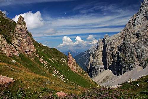
This group is exceptional not only due to the beauty of its mountains, but also because it triggers the following reflection: The mountains of the group are almost as high as those of Julian Alps or even Dolomites. But their rocks are mostly friable, so earthquakes and metheoric impacts have been lowering them constantly. And, think of it, they are almost two times older than the triassic limestons of Julian Alps and Dolomites. So, how high were they originally?
The group of Monte Coglians / Hohe Warte basically consists of one strong ridge on the border between Italy and Austria. Some mountains are quite popular, especially those, which are rising just above the Monte Croce Carnico / Ploecken road pass. The area more towards the west is quite remote and due to demanding and high ascents, the summits are rarely visited - except again the highest summit on the very west. Even more rare are the visits in winter conditions and in times of ski touring. Due to the European Union, state border crossing is not an issue any more.
Geography
The group stretches from the Monte Croce Carnico / Ploecken road pass on the east to the Lago Volaia / Wolayer See on the west. The northern border is the long Valentin Tal. Southern border is harder to determine. We could set it on the Forcella Moraret (and the line Rio Fulin - Rio Collina) or more to the south, on Forcella Plumbs (and the line Rio Plumbs - Torrente But). Doesn't matter much, because there are no high mountains anyway and the geological border goes much north of the Forcella Moraret.
Geology
Even if the variety of rocks in our group is very big, the outline is simple. The whole main crest is built of Devonian (420-360 million years ago) limestone and the area south of Forcella Monumenz is built of Carboniferous (360-300 million years ago) sandstones, slates and clays. The difference is clearly seen. High, grey rocky mountains are towards the south lowering on broad, gentle, hilly green planes. Of course, on the more than 1000 m tall northern walls, almost the whole spectre of devonian rocks is seen. But the thickest is the layer of Middle Devonian limestone, when in warm southern seas more than 800 m of dead skeletons of various organisms were deposited and later compacted in rocks. Later, due to Earth plates collision, a huge mountain chain was formed, millions of years before the Alps had even existed. Many areas of our group are presented by explanatory plates in the nature, being a part of GEO-park. See also Cjalderate, the high mountain karstic area in Devonian limestone, NE of Rif. Marinelli!
As said, the majority of rocks of the main crest is very friable, but there are also high walls of very compact rock. Such examples are the southern pillars of Creta della Cjanevate, some rock walls close to the Monte Croce Carnico / Ploecken road pass, and others. There, climbing routes of highest difficulties are possible.
World War I
Both armies were holding positions on all the summits of our group. The key area of interes was of course Monte Croce Carnico / Ploecken road pass and the mountains above it, but also further towards the west all summits occupied. It was mostly the Italian army holding them, the Austro-Hungarians had only some positions above the road pas. But there were expeditions, on which summits were won, but problems occured later. In winter there was no way how to supply the teams from the Austrian side, so they had to retreat. All normal ascent routes on the summits are the ex military trails. But don't be deceived and think that for that reason they are easy. Some are nicely engineered, but other are real climbs up to UIAA II degree. And soldiers had to master them daily, with all equipment and in any weather condition.
Interactive Map
Before listing the main mountains, let me bring your attention on the interactive map below. It's showing the summits and other features, the routes, some pictures of all this and (by clicking on the routes) giving you also all short route descriptions. That's why it's more than a map - it's a guidebook as well. Here are some technicalities:
- Use +, - buttons to get closer and other tools on the menu left above. The map's web address is here.
- Red lines denote marked routes (in this group it's red spots on the Italian side and Austrian red-white-red marks). Brown lines denote unmarked routes - not all of them, but only up to UIAA degree II. In lower, flat areas (especially the pastures on the SE), cart-roads and easy routes are not specially drawn, but most of them are shown already on the base OpenStreetMap.
- For neatness, some features are hidden, but appear when hovering above them with mouse pointer.
- Difficulties of routes are graded on the Swiss Hiking Scale (hikes), Austrian Ferrata Scale (A to E) and UIAA Climbin Routes Scale (I to VI). But on the map only some climbing routes up to UIAA II degree are shown. All the 3 scales, mentioned above, of course overlap to a certain degree.
- Attention! The contour lines are on some places (especially around the summits and ridges) drawn wrongly - the relief is not captured in the same detail as the rest of topography.
Mountains
| Picture | Name | Altitude | Description | Climbs |

|
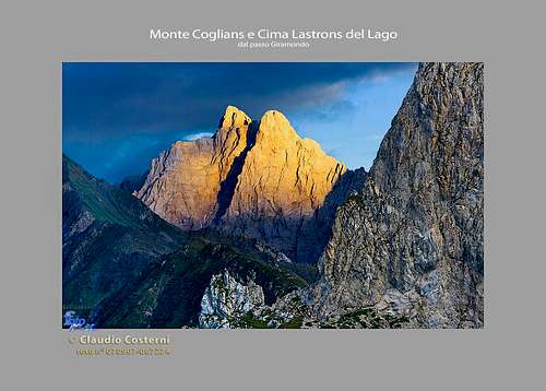
Cima Lastrons del Lago / Seewarte |
2599 m | The westernmost summit in the group, ascended almost exclusively by climbers. | S wall, SW ridge, W wall, NW wall, N wall. |

|
Monte Coglians / Hohe Warte | 2780 m | The highest summit ("must do"). Exceptional panorama. High N wall, rugged S face. Distinct, sharp ridges to the W, E (main) and S. 3 marked routes (1 hike up, 2+1 ferratas), 2 non-marked climbing routes up to UIAA II. Very demanding skiing possible from the summit. 1st ascent: Paul Grohmann & Nicolo Sottocorona, SEP 30th, 1865. | SW wall, W wall, NW ridge, N wall, NE spur, NE wall. |

|
Costone di Stella | 2610 m | The culmination of S-SW ridge of Monte Coglians / Hohe Warte. | W tower. |

|
Pilastro del Coglians | 2732 m | Also: Monte Coglians Eact. Also from the S seen as a sharp tower. Sharp ridges to the neighbours (W and E), marked normal route requires easy climbing (I+). | NE wall. |

|
Cima di Mezzo / Keller Warte | 2713 m | High N wall, the S side is rugged, but a bit less steep. Sharp ridges to the W and E-NE. The marked normal ascent requires some just easy climbing (I-) and has two variants. The climb from the E is not marked and is more demanding (II). | E wall, N wall. |

|
Creta Monumenz | 2499 m | The only high summit (actually more ridge bumps), rising off the main crest - S of it. North of it is the "Cellar" - an easy to reach, deep, hidden, closed valley. The marked normal route is crossing just below the summit and requires only some very easy climbing (I). |
N wall, |

|
Torre della Chianevate / Kellerwandturm | 2726 m | A hard to reach tower in the main crest, W of the Creta della Chianevate / Kellerspitzen. Only reachable to climbers (II). | E crest, S wall, W crest, N wall, E wall. |

|
Creta della Chianevate / Kellerspitzen | 2769 m | The second highest mountain in the group, perhaps even the most attractive. Two summits (W and E), huge, high N wall with a sharp, N-NE crest and with remains of a small glacier NE of the main summit (called: Eiskar). Very compact, broad S wall, consisting of a series of pillars, falling down into the hidden Chianevate valley ("Cellar"). The S pillars are offering very demanding climbs. The marked, very exposed normal route comes along the E crest, but still requires easy climbing (II). | S wall, NW wall, N wall. |
| Cima Est della Creta della Chianevate / Krone | 2744 m | The Eastern fore-summit of Creta della Chianevate is detoured by the normal route on the highest summit. | N wall. | |
| Kunzköpfe | 2298 m | Two summits in the rugged N-NE ridge of Creta della Chianevate / Kellerspitzen. Best reachable from the S, from the edge of Eiskar. | W wall, NE crest. |
|
| Eiskarkopf | 2269 m | Broad, rocky summit, falling towards the Obere Valentinalm with a 680 m tall N wall. From Eiskar easily reachable in a few minutes. | W wall, NW wall, N wall, NE wall. |
|

|
Grüne Nase | 2200 m | High, grassy balcony with a 900 m tall N wall. | NW wall, N wall, NE ravine. |

|
Creta di Collina / Kollinkofel | 2686 m | A massive, popular mountain, the first really high summit in the main crest from the E. From the NE fore-summit a side ridge goes steeply down towards the NE. Remains of a small glacier NW of the main summit (called: Eiskar). Two marked routes: the normal one coming up by the S-SE crest, the more demanding one (II/I) by the E crest. | SW wall, NE wall, NE crest, N crest, N wall, NW wall. |

|
Creta di Collinetta / Frischenkofel / Cellon | 2238 m | A double summit on the very E of the main crest. Very popular due to the near, very frequented road pass. The normal, marked ascent route is a quite easy hike up (T3, some exposed places), more popular are several ferratas. Their difficulties vary from medium demanding to very demanding. The crag above the road pass is arranged for climbing. | SE edge, E pillar, NE wall, NE pillar, N wall, NW crest, W crest. |
| Pic Chiadin | 2302 m | Grassy bump S of the main crest, easily reachable by the hiking path, which traverses just E below the summit. | - | |

|
Cima Plotta | 2149 m | A grassy peak, rising only a little from the grassy plateau east of Rif. Marinelli. | - |

|
Monte Floriz | 2184 m | Grassy bump S of the group (of the Forcella Moraret), easily reachable by the hiking path, which traverses just W below the summit. | - |

|
Monte Gola | 1939 m | Nice, very panoramic summit on the very SW end of the group. No marked path on it, but easily reachable by the E ridge trail. | - |
| See some information about the other minor summits on the map! | ||||
Getting There
See the parent page of Carnic Alps and the map above! By car, you can reach the trail heads:
- Monte Croce Carnico / Ploecken road pass, 1360 m.
- Forni Avoltri - Collina - Rif. Tolazzi, 1350 m.
- Birnbaum - Wolayer Tal, 1114 m.
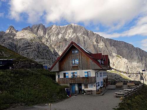
Mountain Huts and Bivouacs
See the parent page of Carnic Alps and the map above! The list is here:
- Rif. E. Tolazzi, 1350 m. Reachable by car.
- Rif. Lambertenghi, 1951 m. 1 h 40 min from Rif. Tolazzi.
- Wolayerseehütte, 1967 m. 2 h from Rif. Tolazzi, 3 h from Wolayer Tal.
- Untere Valentinalm, 1205 m. Reachable by car.
- Rif. Marinelli, 2111 m. 2 h from Rif. Tolazzi, 2 h 30 min from Monte Croce Carnico / Ploecken road pass.
- Eiskar bivouac, ca. 2000 m. Very demanding access from Untere Valentinalm.
Books
- R. Gaberscik: Guida escursionistica alle Alpi Carniche. STUDIO64srl Edizioni. 7th edition, 2010. (An unsurpassable guidebook!). In Italian.
- P. Holl: Karnischer Hauptkamm. Alpenvereinsführer. Rother Verlag. ISBN: 3-7633-1254-4. An excellent overall Climbing Guide through the Carnic Alps Main Ridge. In German.