
|
|
Mountain/Rock |
|---|---|
|
|
46.60700°N / 12.93091°E |
|
|
Hiking, Mountaineering, Sport Climbing, Scrambling, Via Ferrata |
|
|
Summer, Fall |
|
|
7343 ft / 2238 m |
|
|
Overview
 The face where goes the ferrata Sentiero senza confini / Weg ohne Grenzen.
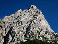
Creta di Collinetta / Celon / Frischenkofel, 2238m is a mountain directly above the pass Passo di Monte Croce / Plöckenpass, 1360m. It is located on the west side of the pass and it is the most eastern mountain in the West Carnic Alps Main Ridge. It is on the border between Austria and Italia and located on the main border ridge that comes from the west side from Hohe Warte / Coglians, 2780m, Kellerspitzen / Creta delle Chianevate, 2769m and Kollinkofel / Creta di Collina, 2689m. On the east side is already mentioned pass.
The mountain has almost 500 meters high north wall above the meadow Untere Valentin Alm on the other side of the valley below. To the east side goes wild ridge with many towers and steep and rocky slopes directly down to the pass Passo di Monte Croce / Plöckenpass. In the lower part there is also a forest. To the west side is connected over the grassy ridge of Cresta Verde / Grüne Schneid, 2150m to the much higher mountain Kollinkofel / Creta di Collina, 2689m. On the south side fall down very steep grassy slopes interrupted with some rocky faces.
 Creta di Collinetta / Cellon, 2238m seen from the summit of Creta di Collina / Kollinspitze, 2689m.
Creta di Collinetta / Celon is easily approachable from the pass. On the normal route from the south side you have to pass only some secured passages. But this mountain is also famous because of the very hard ferrata that goes over its south - east ridge. This is the modern sport and extremly hard ferrata. You have to have a lot of power in your hands. On some places the ferrata is only secured and you have to climb over the vertical face with help of your own hands. But the climbing is a big pleasure because you know that you are well secured with iron cables. But only if you have self - secured system. It is called Sentiero senza confini / Weg ohne Grenzen.
 Creta di Collinetta / Cellon from the east side.
 Creta di Collinetta / Celon seen from the west side.
During the First World War here was the war line. The soldiers built many holes, gallerys, shafts, strongholds and many other war structures you can find here. More then two years was this area occupied with soldiers that tried to protect their part of ground. If you go to the summit over the east slopes and ridge and if you continue to the start of ferrata you will scramble through a very steep tunnel. The tunnel is 180 meters long and when you come out from the tunnel you will be 120 meters high else on the start of the tunnel.
It is nice to connect the ascent on Creta di Collinetta / Celon with the ascent on Kollinkofel / Creta di Collina and further to Kellerspitzen / Creta delle Chianevate. But this trip will take you around 12 hours from the pass Plöckenpass and back to the pass. So very long day. The weather forecast must be good because you will walk on the wild ridges that are exposed to blow of thunderbolts.
But many people decide to visit only the first summit of Celon. This is also a nice trip in high mountains. Maybe the only unpleasant thing is that you have to listen motors that drive to the pass. Because the road is very attractive and has many turns is very popular for motorcyclists. But this will not be a problem because you will hear it rarely.
Getting There
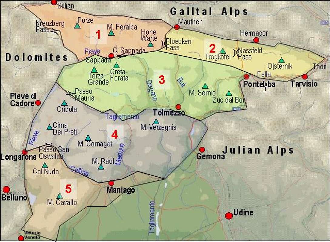
Overview map of the Carnic Alps. Creta di Collinetta / Celon is located on the right side of Hohe Warte / Coglians.
The starting point is the pass Passo di Monte Croce / Plöckenpass. Here is also a big parking place where you leave your vehicle.
From the North
There are two possible roads:
* From Kitzbühel over B108 through the Felbertauern Tunnel to Lienz, then southeast to Oberdrauburg and Kötschach-Mauthen (B110), where you turn to direction Plöckenpass / Italy.
* From Salzburg along motorway A10 to Spittal. Turn west on B100 to Oberdrauburg, there south to Kötschach-Mauthen were you stay on B110 to the pass Passo di Monte Croce / Plöckenpass.
From the South (Udine)
Take Motorway A23 to the exit Camia Tolmezzo. Follow SS52 north to Tolmezzo where you turn onto SS52 bis. This leads to the pass Passo di Monte Croce / Plöckenpass.
 Map of Hohe Warte / Coglians group.
Maps
- Lienzer Dolomiten / Lesachtal
1:50000
Kompass Map WK47
Kompass Verlag
ISBN: 3-85491-053-3
- Tabacco Map, all 1:25000
009 - ALPI CARNICHE / CARNIA CENTRALE
RouteOverview
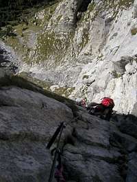 Vertical part of the ferrata.
 On the old military shelves.
There are two main approaches over the marked routes. You can combine some possibilities. For more information click on the routes description.
 Normal approach from the pass Passo di Monte Croce / Plöckenpass over the south slopes. From the pass cross the south slopes and then over the grassy slopes and airy ledge to the east ridge and on the summit. Description. The ferrata Sentiero senza confini / Weg ohne Grenzen. From the pass over the east slopes, face and ridges. Description. Over the east slopes (on the Austrian side) Starts from the pass. An easy ferrata, with some care about falling rocks needed. It joins the other two routes above, below the summit part.
 Ganesh70 (Fabrizio) said: The ferrata "Steinbergerweg" is dedicated to an hero of the austrian army of the WWI ( Simon Steinberger ). I remember that was easy but the iron ropes were in very bad shape, I hope thay renewed it.
There are some climbing routes in north face. I hope Gangolf will help me with this section when he will come from the trip to Julian Alps.
Red Tape
 The alpine jackdaw.
There are no speciality. The only thing is that you will walk on the border between Austria and Italia. Though borders have less and less meaning in Europe today, an ID-card should be in your backpack.
When To Climb
The season starts in June and ends by the end of October. But the mountain can be visited also late in year (November, December), in snowless season.Camping and Huts
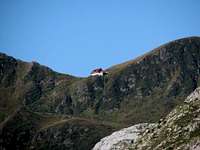 Rif. Marinelli, 2122m.
There is not huts in the nearness. The closest hut is the Rif. Marinelli, 2122m but is along walk to the hut. There are few public houses on the pass Passo di Monte Croce / Plöckenpass.
For the camping section check the main page of the Carnic Alps or the page of the Western Carnic Alps.
Rif. Marinelli (2111 meters): +39-0433-779177
Weather Conditions
The Carnic Alps Main ridge is a weather divide in northern or southern wind conditions so it pays to keep informed. Look at one of the links below :* Tyrol weather
* Carinthia weather
Thanks to Gangolf Haub for this section.