Overview
![Monte la Mucchia]() Monte la Mucchia seen from the south-west
Monte la Mucchia seen from the south-west is one of the near 2000ers of
Montagna del Morrone the mountain chain east of
Sulmona in the
Abruzzo Region of
Appennino Centrale in central Italy. It is located central in the range, which rises out of the surrounding valley for about 1800m. Its mountains are mostly round-topped and
Monte la Mucchia is no exception. The range, which belongs to the greater
Majella Range, but is separated from the latter by the
Passo San Leonardo road pass, is roughly 15km long, starting at
Monte Rotella in the north and ending at twin peaked
Monte Mileto in the south.
Monte la Mucchia is the second summit from the south, standing high above the saddle, which separates it from
Monte Mileto. Its south face is a 100m vertical drop before gradually turning into the smooth slopes that abound on
Montagna del Morrone. Its location just across
Passo San Leonardo from the highest mountains of the
Majella Range makes it a perfect lookout. Moreover
Gran Sasso,
Velino-Sirente and the mountains in the
Abruzzo National Park an on a vast display here.
In general elevation differences between trailheads and the summits of
Montagna del Morrone are huge but here, in the southern part of the chain things are different.
Passo San Leonardo can be easily reached by car (even though seismic activity in the area often shuts down the roads into the mountains and creates serious cracks and bumps) and from there you'll have to scale about 800m only. Thus quite often
Monte la Mucchia is climbed in tandem with its neighbour
Monte Mileto (1920m) or even the highpoint of the chain,
Monte Morrone (2061m). This latter stands to the north-west of
Monte la Mucchia, across another, wider saddle. Even though it is the highpoint of the range, its location, far from any possible trailheads ensures it is rarely climbed.
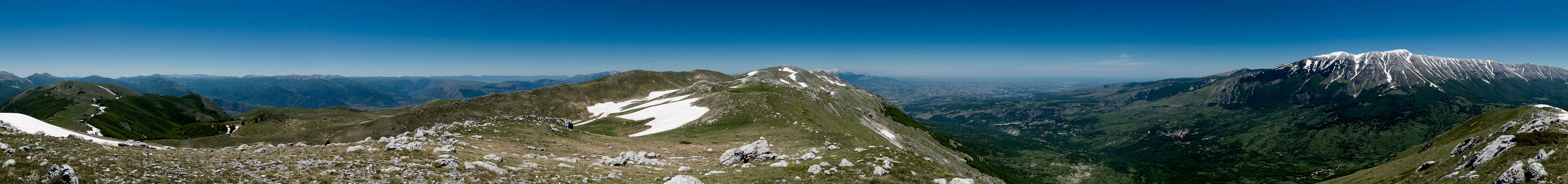
360° Summit Panorama
360° Summit Panorama from Monte la Mucchia |
Getting There
![Monte Morrone and Monte la Mucchia]() Monte Morrone and Monte la Mucchia seen during the traverse from Monte Mileto
Monte Morrone and Monte la Mucchia seen during the traverse from Monte Mileto
The best trailhead for
Monte la Mucchia and the north of
Montagna del Morrone is at the road pass
Passo San Leonardo, which can be reached as follows from the closest airports:
- From Rome:
- Take motorway E80 / A24 from Rome to Torano.
- Switch to motorway A25, direction Pescara.
- At the exit Pratola Peligna / Sulmona switch to SS17.
- After Sulmona switch to SR487 through Pacentro and on to Passo San Leonardo.
- From Pescara
- Take motorway E80 / A25 westward in direction Rome.
- At the exit Pratola Peligna / Sulmona turn off onto SS17 through Sulmona and to SR487 to Passo San Leonardo as described above.
Route
![On the traverse between Monte Mileto and Monte la Mucchia]() On the traverse between Monte Mileto and Monte la Mucchia
On the traverse between Monte Mileto and Monte la Mucchia
From
Passo San Leonardo the route to
Monte la Mucchia is rather straightforward. You leave the chapel in the path towards the north, where a narrow path winds up steeply through beech and oak forest. Above the timberline the trails to
Monte Mileto and
Monte la Mucchia split, with the latter heading for the saddle between the two mountains. Head up a valley heading directly towards
Monte Morrone, to climb
Monte la Mucchia from the north-west. There are no difficulties, except for snow fields which can linger far into early summer.
For descent there is the option of a loop around Monte Mileto. Descend towards the northwest to the next saddle from where a large loop trail leads around
Monte Mileto until you reach a wide dirt road which takes you back to the aforementioned intersection just above the timberline. This loop requires an additional 400m elevation loss and gain but offers great views of the typical terrain of
Montagna del Morrone.
There is a second route, starting in the hamlet
Roccacaramánico starting at 1000m. It negotiates a dense forest to the north of
Rava dell'Inferno, an extremely steep ravine coming down from the saddle between
Monte Mileto and
Monte le Mucchia.
Red Tape
![Viola magellensis]() Viola magellensis
Viola magellensis is part of
Parco Nazionale della Majella. The usual restrictions apply. For more information see the park's website
Accommodation
There's ample accommodation options in the area, however rather hard to find. Google searches often end up at the tripadvisor, casamundo or booking.com portals. There is a thriving community of British expatriates, many of whom offer apartments for rent. Maybe a good starting point is this site
welcometosulmona.com
Closer to the mountain, there's
Rifugio Pietro Celidonio on
Passo San Leonardo. Also, a shelter lies to the south of
Monte la Mucchia,
Casa Capoposto. It can also be directly reached from
Passo San Leonardo.
Weather Conditions
![Majella seen from the saddle between Monte Mileto and Monte la Mucchia]() The Majella Main Ridge
The Majella Main RidgeMaps & Books
Maps
- Digital Maps
- Regular Maps
- Majella
1:25000
Edizioni il Lupo
ISBN: 978-88-86610-68-1
Books
- Abruzzen
Heinrich Bauregger
Rother Verlag
ISBN 978-3-7633-0413-2

 1110 Hits
 78.27% Score
 9 Votes
 Monte la Mucchia seen from the south-west


 Monte Morrone and Monte la Mucchia seen during the traverse from Monte Mileto
 On the traverse between Monte Mileto and Monte la Mucchia
 Viola magellensis
 The Majella Main Ridge