
|
|
Mountain/Rock |
|---|---|
|
|
42.44190°N / 13.68320°E |
|
|
Hiking, Scrambling |
|
|
Spring, Summer, Fall, Winter |
|
|
8402 ft / 2561 m |
|
|
What's new
- 1 November 2006: start-up of the page- 13 January 2007: added the section "When to climb" and new photo
- 9 September 2007: addedd the new route-page "Via dei Laghetti"
Overview
 Campo Imperatore and Fornaca
From the centre of the Gran Sasso group (Abruzzo region), corresponding to the summits of the Corno Grande, departs a very long ridge of about 20 kilometers called Cresta Orientale (Eastern Ridge). The ridge is running in the direction W-E and is characterized by some interesting peaks. It is a boundary among the Altopiano di Campo Imperatore (S side) and the hills of the Abruzzo region. The highest summit of the ridge is Monte Camicia (2564 m), while only few meters lower is Monte Prena (2561 m). Other mountains, such as Monte Brancastello (2385 m), Torri di Casanova (2362 m), Monte Infornace (2469 m) represent interesting targets for hikers and climbers in this area.
![Monte Prena from East]() S-SE sideMonte Prena is placed in the middle of the Cresta Orientale, close to Monte Infornace and Monte Camicia. The position allows a 360° view to the surrounding mountains and, in case of good weather condition, even to the main summits of Appennino Centrale (Monte Amaro, Monte Velino e Sirente, Monte Viglio, Terminillo) and to the Adriatic coast. The peculiar environment of the area, with woods, meadows (mainly in the N-side), gravelly and rocky valleys (like Fornaca and la Canala, recalling the canyons) and a green flat plateau (on the S-side) is always attractive for the hikers during the good season.
S-SE sideMonte Prena is placed in the middle of the Cresta Orientale, close to Monte Infornace and Monte Camicia. The position allows a 360° view to the surrounding mountains and, in case of good weather condition, even to the main summits of Appennino Centrale (Monte Amaro, Monte Velino e Sirente, Monte Viglio, Terminillo) and to the Adriatic coast. The peculiar environment of the area, with woods, meadows (mainly in the N-side), gravelly and rocky valleys (like Fornaca and la Canala, recalling the canyons) and a green flat plateau (on the S-side) is always attractive for the hikers during the good season.
![Monte Prena and Fornaca valley]() The canyon
The canyon
Also more experienced climbers can find interesting routes to this mountain, as well as to close higher Monte Camicia. I climbed Monte Prena from South in the fall season during a wonderful sunny and warm day. From June to October you can ascend without snow. It is ascended also in winter, mainly from South, where few routes run along steep snowy couloirs.
From Campo Imperatore – S-routes:
The fastest way, by car, is the Highway A24-Roma/L’Aquila. Exit at Assergi (about 120 km Rome) and proceed by the S.S. 17-bis to Campo Imperatore (about 25 km). In summer, when the road up to Campo Imperatore is practicable (no snow), you can reach the starting point by car. At about 1550 m, leave the road turning to left to the Campo Imperatore cable station and continue following the indication to Pescara. From the flat road depart few secondary not asphalted roads that you can follow (it is not clear if it is forbidden or not) in order to reach the starting point of the trails.
From Pretara – N-routes:
Take the highway A24-Roma/L’Aquila. Exit at S.Gabriele-Colledata (about 22 km from the Adriatic sea and 54 km from L’Aquila) and proceed to Isola del Gran Sasso (about 8 km). Overcome the village of Pretara till the Lago di Pagliara (7 km from Isola del Gran Sasso, at 852 m).
In case of need and emergency you can call the phone number 800.25.82.39, operating in all the Abruzzo region.
![Via Brancadoro]() Via Brancadoro
Via Brancadoro
Yellow-red or only red indications identify the trails, not always confortable and sometimes only traces. The difference of altitude is not so hight, but the approach to the routes is sometimes long and tiring (expecially coming back).
![Ascending Monte Prena]() Via Brancadoro
Via Brancadoro
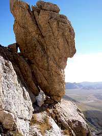
S-side, “Via dei Laghetti” – height difference 1000 m from the plateau, PD-, with passages of UIAA III- grade (4:30-5:00 h). Interesting and long route ascended by most of the climbers/hikers.![Via dei Laghetti]() Via dei LaghettiIt is characterised, in late spring, by evocative little lakes (it should be better to say pools) where you can dive;
Via dei LaghettiIt is characterised, in late spring, by evocative little lakes (it should be better to say pools) where you can dive;
S-side, “Via Brancadoro” – height difference 1000 m from the plateau, F with passages of UIAA II grade (4:30-5:00 h);
S-side, Normal route, height difference 1000 m from the plateau, through Fornaca valley, Vado di Ferruccio and N-side (3:30-4:00 h).
“Via del Centenario” – through the long W-ridge from Vado di Corno. The trail continues on the E-ridge to Monte Camicia (8:00-8:30 h);
N-side – through the Cimetta (2256 m), height difference 1700 m from the Lago di Pagliara (6:00-6:30 h);
N-side – through the Fonte del Peschio (1373 m), height difference 1190 m from the Fonte del Peschio (3:30-4:00 h);
![Summit view]() Panoramic view
Panoramic view
No fees and parking pass are required. You are in the National Natural Park of Gran Sasso and you must respect the specific rules stated for the protection of the environment.
![Monte Prena - W side in winter]() Winter view from Centenario trailYou can climb Monte Prena all the year. The difficulties change from one season to the other, and in summer it is more frequenced than in winter.
Winter view from Centenario trailYou can climb Monte Prena all the year. The difficulties change from one season to the other, and in summer it is more frequenced than in winter.
![Monte Prena S-SE side]() S-view
S-view
Albergo "Campo Imperatore", tel +39-0862-400000 but you will be probably re-directed to another number (+39-0862-21191) when the Albergo is closed. This is the most expensive solution, even if more confortable (it is a 3 stars hotel, not a refuge!);
Refuge "Campo Imperatore", 42-72 beds, open all the year, just close to the upper cablecar station to which is also connected by a gallery of about 90 meters (phone: +39-0862-400011)
- Grazzini L., Abbate P., "Gran Sasso d’Italia - Guida dei Monti d’Italia." Club Alpino Italiano-Touring Club Italiano, 1992 - ISBN 88-365-0518-X
- Ardito S. "A piedi in Abruzzo", 2003. Guide ITER (Subiaco, Roma) – ISBN 88-8177-029-6.
- Alesi A.,Calibani M. ,Palermi A. , “Gran Sasso – Le più belle escursioni”, SER, 1996
The main maps are the IGMI n° 140 III NO (Gran Sasso d’Italia), 1:25000 and CAI Gran Sasso d’Italia (1:25000)
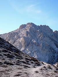 S-SE side
 The canyon
Also more experienced climbers can find interesting routes to this mountain, as well as to close higher Monte Camicia. I climbed Monte Prena from South in the fall season during a wonderful sunny and warm day. From June to October you can ascend without snow. It is ascended also in winter, mainly from South, where few routes run along steep snowy couloirs.
Getting There
The main starting point is from the plateau of Campo Imperatore (about 1550 meters). Here is the start to the route on South-side. The approach from North is possible starting from the village of Pretara(523 m).From Campo Imperatore – S-routes:
The fastest way, by car, is the Highway A24-Roma/L’Aquila. Exit at Assergi (about 120 km Rome) and proceed by the S.S. 17-bis to Campo Imperatore (about 25 km). In summer, when the road up to Campo Imperatore is practicable (no snow), you can reach the starting point by car. At about 1550 m, leave the road turning to left to the Campo Imperatore cable station and continue following the indication to Pescara. From the flat road depart few secondary not asphalted roads that you can follow (it is not clear if it is forbidden or not) in order to reach the starting point of the trails.
From Pretara – N-routes:
Take the highway A24-Roma/L’Aquila. Exit at S.Gabriele-Colledata (about 22 km from the Adriatic sea and 54 km from L’Aquila) and proceed to Isola del Gran Sasso (about 8 km). Overcome the village of Pretara till the Lago di Pagliara (7 km from Isola del Gran Sasso, at 852 m).
In case of need and emergency you can call the phone number 800.25.82.39, operating in all the Abruzzo region.
Route overview
Monte Prena can be climbed by three main different routes on the S-side and two routes on the N-side. The routes starting from Campo Imperatore are more interesting and ascended by most climbers.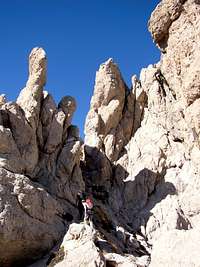 Via Brancadoro
Yellow-red or only red indications identify the trails, not always confortable and sometimes only traces. The difference of altitude is not so hight, but the approach to the routes is sometimes long and tiring (expecially coming back).
 Via Brancadoro
S-side, “Via dei Laghetti” – height difference 1000 m from the plateau, PD-, with passages of UIAA III- grade (4:30-5:00 h). Interesting and long route ascended by most of the climbers/hikers.
 Via dei Laghetti
S-side, “Via Brancadoro” – height difference 1000 m from the plateau, F with passages of UIAA II grade (4:30-5:00 h);
S-side, Normal route, height difference 1000 m from the plateau, through Fornaca valley, Vado di Ferruccio and N-side (3:30-4:00 h).
“Via del Centenario” – through the long W-ridge from Vado di Corno. The trail continues on the E-ridge to Monte Camicia (8:00-8:30 h);
N-side – through the Cimetta (2256 m), height difference 1700 m from the Lago di Pagliara (6:00-6:30 h);
N-side – through the Fonte del Peschio (1373 m), height difference 1190 m from the Fonte del Peschio (3:30-4:00 h);
Red Tape
 Panoramic view
No fees and parking pass are required. You are in the National Natural Park of Gran Sasso and you must respect the specific rules stated for the protection of the environment.
When to climb
 Winter view from Centenario trail
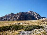 S-view
Refuges and accomodations
The closest refuge is at Fonte Vetica (1632 m). This is a restaurant and the main starting point to Monte Camicia. Possible accomodation is close the cablecar station at Campo Imperatore (2120 m), starting point for the ascents to Corno Grande and other summits of the Gran Sasso massif.Albergo "Campo Imperatore", tel +39-0862-400000 but you will be probably re-directed to another number (+39-0862-21191) when the Albergo is closed. This is the most expensive solution, even if more confortable (it is a 3 stars hotel, not a refuge!);
Refuge "Campo Imperatore", 42-72 beds, open all the year, just close to the upper cablecar station to which is also connected by a gallery of about 90 meters (phone: +39-0862-400011)
Books and Maps
Three books in Italian including not only routes towards the Monte Prena but even in Gran Sasso massif:- Grazzini L., Abbate P., "Gran Sasso d’Italia - Guida dei Monti d’Italia." Club Alpino Italiano-Touring Club Italiano, 1992 - ISBN 88-365-0518-X
- Ardito S. "A piedi in Abruzzo", 2003. Guide ITER (Subiaco, Roma) – ISBN 88-8177-029-6.
- Alesi A.,Calibani M. ,Palermi A. , “Gran Sasso – Le più belle escursioni”, SER, 1996
The main maps are the IGMI n° 140 III NO (Gran Sasso d’Italia), 1:25000 and CAI Gran Sasso d’Italia (1:25000)