
|
|
Mountain/Rock |
|---|---|
|
|
42.47330°N / 12.99720°E |
|
|
Hiking, Mountaineering, Trad Climbing, Ice Climbing, Scrambling |
|
|
Spring, Summer, Fall, Winter |
|
|
7270 ft / 2216 m |
|
|
Intro
 The waves
Overview
Monte Terminillo (2216 meters) is located in Monti Reatini group belonging to chain of Appennino Centrale (Central Italy). Its name has an old origin from the Latin “terminus”, that means “end”; it was a reference point for the ancients. It is considered the “mountain of Rome” due to the closeness to Rome and its most recent history. Most of the Roman citizens, like me, started to learn skying on the snow of this mountain in the Sixties. In that period the area around Terminillo (mainly in Pian dé Valli, 1614 meters) developed very much, even if the first cableway was built in 1938. Horrible buildings and some hotels grew up, in contrast with the landscape and the enviornment. Recent attempts for several new chairlifts on the flanks of Terminillo up to the the summit of Terminillo are in place. Nevertherfore, the nature is still present in Terminillo. ![The ridge from the summit of...]() From the summit to the TerminillettoMainly hikers, but also climbers, could find interesting routes deeply in contact with the nature, from spring to autumn, and amusing couloirs, in winter. Linked to the main summit of Terminillo there are some other minor mountains. At East: Monte Elefante (2015 meters)
From the summit to the TerminillettoMainly hikers, but also climbers, could find interesting routes deeply in contact with the nature, from spring to autumn, and amusing couloirs, in winter. Linked to the main summit of Terminillo there are some other minor mountains. At East: Monte Elefante (2015 meters)![Monte Elefante]() Monte Elefante, famous for some very interesting winter routes on the N-side, Monte Valloni (2004 (meters), Monte Brecciaro (1954 meters) and Monte Cambio (2081 meters). Towards the South there are the Terminilletto (2105 meters) and the so-called “Conetto” (1853 meters). To the North, the Cresta Sassetelli, with two summit at 2079 meters and 2119 meters, and Cresta dell’Acquasanta.
Monte Elefante, famous for some very interesting winter routes on the N-side, Monte Valloni (2004 (meters), Monte Brecciaro (1954 meters) and Monte Cambio (2081 meters). Towards the South there are the Terminilletto (2105 meters) and the so-called “Conetto” (1853 meters). To the North, the Cresta Sassetelli, with two summit at 2079 meters and 2119 meters, and Cresta dell’Acquasanta.
![Cresta Sassetelli]() Cresta Sassetelli
Cresta Sassetelli
 From the summit to the Terminilletto
 Monte Elefante
 Cresta Sassetelli
However, the most interesting side, from the point of view of climbers, are the steep North and North-East sides of Terminillo. Althought the limited difference in height (not more than 200 meters), Terminillo has a great variety of couloirs to be climbed in winter. These route are really interesting, sometimes difficult depending on the snow-ice condition, and they represent a suitable training for people loving these kind of ascent.
Rock climbing is possibile, even if the rock quality is considerd not very good. First climbers were Stanislao Pietrostefani and Roberto Chiaretti in 1932 and new attempts were done only from the end of the sixties.
From the summit the view is really wonderful towards the Gran Sasso (Corno Grande), Monti Sibillini, Monti della Laga and Monte Velino: all interesting mountains in Central Italy.
![The SW-ridge towards the...]() View of Terminillo from the SW ridge
View of Terminillo from the SW ridge
 View of Terminillo from the SW ridge
Getting There
Terminillo is well connected by roads. The start of the ascents is from Pian dè Valli (1614 meters) about 100 km far from Rome. Some routes start directly from the Rifugio Sebastiani (1820 meters), reacheable also in winter, continuing the same road, with few bents, after Pian dè Valli. In case of snow or ice on nthe road, you are obliged to stop your car at Pian dè Valli and consider additional 30 minutes up to Refuge Sebastiani.
FROME ROME: The fastest way to Pian dè Valli is the Highway A1-Roma/Firenze. Exit at Fiano Romano, then proceeding to Rieti by SS4-Salaria, and after 20 km about, following the indication to Terminillo, you arrive at a parking area.
FROM L'AQUILA: SS17 Bis to Rieti, then SS4 Bis to Terminillo.
![Terminillo NE side map]()
 |
Route overview

 | Some summer routes for hikers to the Terminillo summit are shortly cited: - from Pian dé Valli (W-NW ridge): trail n°2 and n°1 (red-white indication) through Bosco Cardito, Sella di Vall’Ongaro, Cresta Sassetelli. Ascent 680 m; 3:00-3:30 hours; - from Pian dé Valli (SW ridge): through Terminilletto (2105 meters), Sella Cavallo. Ascent 660 m; 2:15-2:30 hours; - from Rifugio Sebastiani (Normal route, E-SE ridge): trail n°1 (red-white indication). Ascent 400 m; 1:15-1:30 hours; - from Rifugio Sebastiani (NW ridge): trail n°3 (red-white indication) through Valle Meta, Vetta Sassetelli (2119 meters). Ascent 500 m; 2:15-2:30 hours. |
 |  | Some winter routes to the summit of Terminillo: - from Rifugio Sebastiani: Chiaretti-Pietrostefani route-NE side-N ridge, PD+. Ascent 350 m; 2:30-3:00 hours; - from Rifugio Sebastiani: 1 Maggio (1st May) route-N side, PD+. Ascent 350 m; 2:30-3:00 hours; - from Rifugio Sebastiani: Orsacchiotta (Teddy Bear) route-NE side, PD+. Ascent 350 m; 2:20-2:45hours; - from Rifugio Sebastiani: Canale che non c'è route-NE side, AD. Ascent 350 m; 2:30 hours; - from Refuge Sebastiani: on the NE side there are a lot of couloirs of different difficulty, used in same cases even as descending routes; - from Valle del Sole: on the W side there are some coulouirs, unnamed and rarely ascended. |
Routes on rock to the summit of Terminillo:
- N-wall: Bianchetti-Sciarra route, 1977. 150 m from the base (VI, A1); 4:00 hours;
- N-wall: Ferri-Smargiassi route, 1986. 150 m from the base (IV, V+); 3:30 hours;
- N-wall: Ferri-Venditti route, 1999. 150 m from the base (V); 2:00 hours;
- N-wall: Ferri-Sola route, 2001. 100 m from the base; 2:00 hours;
- N-wall: Diletti-Brucchietti (1st May route), 1977. 150 m from the base (I); 0:50 hour;
- N-wall: Diletti-Brucchietti-Marinelli (NW route), 1968. 150 m from the base (II); 1:30 hour;
- NE-side: Ferri-Ratini-Venditti-Sola route, 2000. 60 m from the base (V+,A1); 0:45 hours;
- NE-side: Sola (Davide route), 2001. 60 m from the base (IV+,VI-); 1:30 hours;
- NE-side: Brucchietti -Millesimi (Central Spur route), 1976. 150 m from the base (II, III); 1:30 hours;
- NE-side: Brucchietti -Branchetti (Edge-Central Spur route), 1978. 100 m from the base (III, IV); 1:30 hours;
- NE-side: Brucchietti -Olivieri (Paola route), 1977. 150 m from the base (IV+, V-); 1:30 hours;
- NE-side: Brucchietti -Catini (Antonella route), 1977. 150 m from the base (IV+, V-); 1:30 hours;
- NE-side: Placca route on the Central Spur, 1977. 150 m from the base (IV+, V+); 1:30 hours.
![The calcareous Terminillo in...]()
- N-wall: Bianchetti-Sciarra route, 1977. 150 m from the base (VI, A1); 4:00 hours;
- N-wall: Ferri-Smargiassi route, 1986. 150 m from the base (IV, V+); 3:30 hours;
- N-wall: Ferri-Venditti route, 1999. 150 m from the base (V); 2:00 hours;
- N-wall: Ferri-Sola route, 2001. 100 m from the base; 2:00 hours;
- N-wall: Diletti-Brucchietti (1st May route), 1977. 150 m from the base (I); 0:50 hour;
- N-wall: Diletti-Brucchietti-Marinelli (NW route), 1968. 150 m from the base (II); 1:30 hour;
- NE-side: Ferri-Ratini-Venditti-Sola route, 2000. 60 m from the base (V+,A1); 0:45 hours;
- NE-side: Sola (Davide route), 2001. 60 m from the base (IV+,VI-); 1:30 hours;
- NE-side: Brucchietti -Millesimi (Central Spur route), 1976. 150 m from the base (II, III); 1:30 hours;
- NE-side: Brucchietti -Branchetti (Edge-Central Spur route), 1978. 100 m from the base (III, IV); 1:30 hours;
- NE-side: Brucchietti -Olivieri (Paola route), 1977. 150 m from the base (IV+, V-); 1:30 hours;
- NE-side: Brucchietti -Catini (Antonella route), 1977. 150 m from the base (IV+, V-); 1:30 hours;
- NE-side: Placca route on the Central Spur, 1977. 150 m from the base (IV+, V+); 1:30 hours.
 |  |  |  |
Red Tape
No fees and parking pass are required.When To Climb

Terminillo is a good place for hikers from advanced spring to autumn, while it is the perfect place for climbers, loving ice-climb, couloirs, ice-axes and so on, in winter. In the recent time (the last four years) a lot of snow covered the Terminillo in winter till mid-spring and the snow condition are changing quickly every week. In 2004 and 2005 we ascended with good snow even in advanced April and this year (2006) the amount of snow is really fantastic. 2009 started with a lot of snow and low temperatures: perfect.
There are good indications for the trails, that are recently updated and renewed (the original yellow-red colours have been changed by red-white).
 |  |  |  | |
Huts
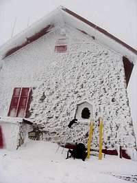
Two refuges, belonging to Club Alpino Italiano (CAI) are open in the area.
 | - Rifugio Sebastiani (1820 meters). 30 beds, open all the year (excepted a short period in october). Is the most suitable starting point to the North and North-East sides of Terminillo. Contact Mr. Maurizio Sola: e-mail rifugioangelosebastiani@virgilio.it - Telephone 0039-0746-261184 - mobile: 0039-338-4812388 |
 | - Rifugio Rinaldi (2108 meters). Located on the top of Terminilletto. 12 beds. It is normally closed (excepted in August), but the keys could be required to the office of CAI in Rieti (about 20 km far). |
Mountain Conditions
The best thing to do, for any doubts about the weather or the condition of the routes (expecially in winter), is to call the owner of Refuge Sebastiani (see above).
Weather current conditions:
Monte Terminilluccio (1875m)
Webcam live
Terminillo north-east side view from Sebastiani hut (1820m)
Zoom on Terminillo north east side
Weather current conditions:
Monte Terminilluccio (1875m)
Webcam live
Terminillo north-east side view from Sebastiani hut (1820m)
Zoom on Terminillo north east side
In addition, a useful site could be the Aeronautica Militare-Servizio Meteorologico web site (In Italian).