
-
 5148 Hits
-
 79.04% Score
-
 10 Votes
|
|
Mountain/Rock |
|---|---|
|
|
45.93067°N / 11.41360°E |
|
|
Hiking, Mountaineering, Skiing |
|
|
Spring, Summer, Fall, Winter |
|
|
6611 ft / 2015 m |
|
|
Overview
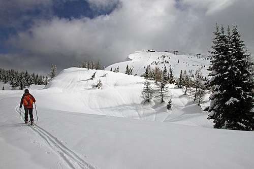
Ascending M. Verena from the SW
Intro
Even if Monte Verena (also: Cima Verena) is opened for mass tourism, it is a fine, high mountain. At the end, you don't need to go up there by chair lift. What can be for some a family outing, can be for others a challenging ski tour descent. Or an enduring mountain bike tour. To have a more complete picture of Asiago Plateau mountains, Monte Verena simply must be added on SummitPost. For its central position and its variety.Geologically, Monte Verena is built of Jurassic limestone, sometimes mixed with dolomite.
The Mountain Which Started A War
Well, the mountain can of course not be blamed for human stupidity, but on May 24th, 1915, at 4:00 a.m., after Italy decided to switch the side in global aliances, heavy guns from Monte Verena pushed the country into the Big War. But more about the big fort on top of the mountain comes later...Central Position Above Tableland
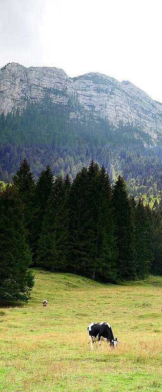
The inhabited parts of broad plateaus of Asiago, Lavarone and Folgaria lie on around 1000 meters of altitude. North of them the main chain of mountains reaches 2336 meters and south of it some distinct summits still reach above the timberline. Monte Verena rises north-west of Asiago. Around it the deep valley of Assa creek is carved, so Verena is a stand alone mountain with quite a high prominence. A summit ridge is going in the NW-SE direction and from the top another two, less distinct, humble side ridges lower towards the south and south west. The southern side of the moutain is moderately steep and is used for ordinary ski terrains. The northern side is however very steep and rocky on top and only below that rock barrier steep woods continue down towards Assa valley.On the lower parts of Monte Verena there are many nice, broad alpine meadows. They are connected by forrest roads, which makes the whole area great for biking and cross country skiing. On some of those meadows there are mountain huts which are opened for visitors, some of them even in winter. And, finally, there is a mountain road which ascends on the very top of Monte Verena. It was built to serve the big fortress on top and is today of course closed for public traffic.
Outing On Monte Verena
In a snow rich winter
2. Hiking. That's always an option. In summer you can use the mountain road or good marked paths which go by the SW and E-SE ridge. In winter people do much of snowshoeing (ciaspole) here.
3. Tour skiing. Monte Verena is a nice mountain for tour skiing. The ascents from the south are obstructed by the ski resort, otherwise they would be easy. The northern ascents and then skiing down there are much more demanding, but nice.
4. Mountain biking. You can start the tour anywhere, even down in Roana or the nearby Mezzaselva. Nice is the tour which encircles the whole mountain, much more challenging is the tour on top.
5. Cross country skiing. On Campolongo, south on the plateau below Monte Verena, there is a big cross country ski center. As on most of these big centers you need to pay it. But it can also happen that the access to the parking place is free. The Campolongo tracks go some 25 kilometers away, even to the town of Luserna, but combining them, you can ski through the nice woods and over meadows for hours and hours (some 100 kilometers of tracks).
Summit Views


Reaching the top - on the fort roof
Getting There

Verena ski resort
From this parking place a chair lift goes on top. It operates also in summer.
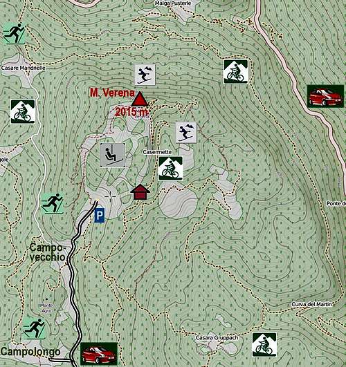
A possible trailhead would be also Malga Pusterle, 1300 m. This nice alpine meadow (with agroturismo) lies on the northern slopes of Monte Verena. It can be reached by car from the main road, going by Assa valley. From the meadow you can not drive further on, because all mountain and forrest roads are closed for public traffic. Malga Pusterle can be the starting point of a bike tour, or the trailhead of a demanding ski tour over the north slopes of Monte Verena.
Monte Verena Tours
Hikes
There is not much to describe here, because from the SW, S and SE many easy paths ascend and you can easily combine them to make a round tour. To ascend Monte Verena from Rifugio Verenetta, 1651 m, you need just one hour - and some kind of a map, if you don't want to go up just by the ski slopes. In winter the ascent is a bit more difficult, because walking up (with snowshoes) over the ski terrains is strictly prohibited. So, it is best to hit the mountain road which goes up below the ridge, on the eastern side of ski terrains.Perhaps the most recommendable hike up in summer is the round tour which uses the marked path No. 820. You start on the big parking place by Rif. Verenetta, 1651 m, then find west of it the mountain road which the marked path uses, and go by it towards the N. When reaching the summit clearings, you continue towards the NE on top. The descent goes first by the E ridge. On the edge below, you may visit another fortress - ex Batterie Rossapoan, 1890 m, and then continue towards the SE on Malga dei Quarti and back towards the SW on the main road which you reach near Campovecchio, 1593 m.
The ascents from north are much steeper on top. There is no marked path. Please add information if you have it!
Ski Tours

On the SW summit slope

The E-SE slopes
Northern descents with skis are much more demanding. There is usually a big corniche over the summit abyss, so unless you know the terrain and conditions very well, it is advisable to do first the ascent up there and only then to ski down. From the summit ridge two steep ravines go down. The trailhead of these difficult tours is Malga Pusterle, 1300 m, but if the road is not cleaned till there, even the main road down in Assa valley.
Forte Verena

Forte Verena

Skiing from the roof of Forte Verena
Italian army built the fortress in the years 1910 to 1914. The purpose was, as with all other big forts of this area, to defend the border with Austro-Hungarian empire. It looks that everybody at that time felt that the existing border was not natural and will not last long. Only a year after the fort was built, that proved true. As the fort was built in hurry not much steel was used, so the construction was made more of concrete, by the old standards, assuming on the enemy side only guns up to 100 mm. That proved to be fatal during the war.
On May 24th, 1915, the first heavy gun shots were fired from Forte Verena, announcing the entry of Italy into the Big War. Due to its strategic position in the first weeks of war the heavy guns could succesfully hit importants objects (forts) on the Austro-Hungarian side. That is why Forte Verena was dubbed il "Dominatore dell'Altopiano" (the dominator of tableland). To remove the threat, Austro-Hungarians prepared a Škoda heavy gun, 305 mm, and already on June 12th Forte Verena was heavilly hit. A grenate perforated the wall and exploded in the interior, just in the gunpowder room. A crew of 46 men was killed, including the commander of the fort. In the next days shelling continued and the majority of vital objects was destroyed. So, Italians removed the guns and continued to use the fort only as an observation point. Next year, in June 1916 a big Austro-Hungarian offensive started (Straffexpedition), the fort was seized and stayed in Austro-Hungarian hands till the end of war.
Mountain Huts
On Monte Verena there are many huts, but they are actually not needed for the ascents themselves:1. Rif. Verenetta, 1651 m, near the big parking place, south of Monte Verena.
2. Rif. Monte Verena, 2015 m, on the top of Monte Verena, reachable by chair lift (also in summer).
3. Baito Spelonca, cca 1775 m, a shelter only, by the mountain road on Verena.
4. Malga dei Quarti Verena, 1654 m. South-east of the summit.
5. Agriturismo Malga Pusterle, 1300 m. North of the mountain, in summer reached by a mountain road.
6. Rifugio Campolongo, 1540 m. By the big parking place of the cross country ski center.
7. Many private huts on alpine meadows around Monte Verena.
When To Ascend Monte Verena?

Campovecchio in winter

In a snow rich winter
Northern ski descents require avalanche safe conditions. The summit ravines are very steep, so the tours there are best done in spring, quite many days after the snowfall.