
|
|
Area/Range |
|---|---|
|
|
17.55°S / 149.815°W |
|
|
3959 ft / 1207 m |
|
|
Overview
Despite the low altitude of the peaks, the mountains of Moorea are among the most rugged in the world and every bit as rugged as the Himalayas. Unlike the Himalayas however, most peaks on this and the surrounding islands are considered impossible to climb and many still await first ascents. Although the peaks are not high in elevation, they should not be under estimated. Almost all are serious climbs.
While Moorea and Tahiti are very popular with tourist, expect to have the mountains all to yourself. I never did meet anyone on any of the routes. It seems almost everyone hangs out at the lagoon, beaches, and resorts instead of climbing mountains, which is a good thing if you enjoy solitude.
SP member Kane was the original submitter of this page, and supplied many good photos.
SP member Kane writes: In the spirit of unknown exploration and primitive mountaineering, I submit the volcanic crater of Moorea. If you haven’t heard of Moorea, think Jurassic Park. I thought the addition of this mountainous island might spawn some curiosity for the South Pacific and its volcanic geology. Moorea is not run down with hotels and clubs, the island is still pristine and primitive and full of Tahitian culture.
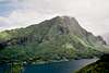
Moorea is an island of volcanic origin, located 11 miles northwest of Tahiti and has a circumference of 37 miles. Many people have described Moorea as the most beautiful place on earth. After a visit to Moorea and inspired by its beauty, author James Michener’s wrote the fictional book Bali Hai, a book depicting paradise. In his book he writes, “peaks which can never be forgotten...the jagged saw-edges that look like the spines of a forgotten dinosaur”. One of the features that is so striking about this island is the jagged peaks and spires that give the island its unique profile. Moorea's appearance is the result of volcanic activity hundreds of thousands of years ago.
The volcanic crater of Moorea is completely surrounded by a coral reef; thus leaving a natural lagoon only matched by Moorea’s sister Island of Bora Bora. Geologists speculate that the northern rim of the volcano either fell into the sea or was blown away by a volcanic explosion, leaving the heart-shaped island of Moorea. The south rim of the volcano makes up the mountain range that protects the lush interior of the island known as the Opuhi plantation. This astounding range that makes up the south rim contains several named mountain peaks. Towering some 3,000 ft. above Opunohu Bay and Cooks Bay (named after Captain James Cook), Mt Rotui (2,949 ft.) resides at the center of the crater of the ancient volcano. The view of Rotui from Belvedere Point is spectacular. Frequently depicted on post cards, Mouaputa is known by the locals as “Bali Hai,” or the “Shark’s toothhas a small hole through the very top of the mountain. On my visit to Moorea I saw a helicopter fly through this hole and land on the top!
 |
 |
 |
 |
 |
Getting There
Getting to Moorea is easy. First, you must fly to Papeete (actually the suburb of Faaa), the capital of French Polynesia which is located on the island of Tahiti. From the wharf at Papeete, several ferries depart for the island of Moorea between the hours of 6 am and 5:30 pm. The boat ride cost $9-10 each way in November 2005, and takes 30 minutes to an hour depending on what boat you book with (ferries that take vehicles are slower).
Once on Moorea and at Vaiare, you will notice two busses waiting for passengers. Bus schedules always correspond with the ferry schedules on Moorea. There will be a bus that travels the north side of the island, and one that travels the south side. To circle the island, you will have to transfer busses. In November 2005, the bus fare was $3 regardless of the destination.
 |
 |
 |
 |
 |
Moorea's Named Peaks
Overview of Hiking and Climbing Routes
SUMMIT ROUTES
Tohiea: There is very little information on Tohiea, the highest peak in Moorea, available. Mike Kelsey, author of the Climbers and Hikers Guide to the Worlds Mountains, 4th edition, states that the mountain is “almost impossible to climb and thus won’t be included in the book”. After checking with the local climbing club, I learned that the mountain has been climbed from the east, and is very difficult, but no other information was available.
Mouaputa: Apparently the only route that has been climbed is the Vaioro Valley Route and it is no walk up. The route is extremely dangerous, especially on the descent, if it has been raining. The last section is very scary and dangerous when wet and there are eight fixed rope sections. Click on the link for more details.
Rotui: This peak is the easiest of the main summits of Moorea, but is still fairly challenging. Apparently, there has only been one route that has been climbed on the mountain. A Texan party did try to climb the southwest face a few years ago, but they were killed when the pitons pulled out. The only practical route up the mountain is via the north ridge. In some places, you must cling to vines while climbing up steep sections, and in a few places, there are fixed ropes which you can use. If it is dry, the main obstacle is the heat. This is a very hot climb. If it is wet, getting down can be risky, but the climb is not as dangerous as Mouaputa. In the rain, expect to fall at least a few times. Click on the link for more details.Magic MountainA nice hike with fine views, but there is a 4wd track 4/5 of the way up the peak. The peak is more of a hill than a mountain when compared to the rest of the peaks of Moorea, but is a nice hike. This would be the "tourist peak" of the island. By far, the vast majority of the people coming up here are tourist on a 4wd tour (this is actually how we came here too!). From the summit, there are some nice views of the peaks, and especially of Rotui. If taking a 4wd, it is only a 10 minute walk or so. The 4wd road can also be walked, if you don’t want to come up here on a tour. The 4wd track starts from near the village of Papetoai. Inquire locally for the track up Magic Mountain. The hike should take several hours round trip.
NON-SUMMIT ROUTES As mentioned, most of the other peaks are considered to be impossible (or nearly so), so there won’t be any information available on climbing these peaks.
Below are several good routes that will take you near the mountains and to passes for some really good close-up views of the spectacular peaks, without reaching the highest points of the said peaks.
Vaiare-Paopao Route: This route crosses the island from the ferry wharf to Cooks Bay and can make a good return route from Mouaputa if you are staying at Cooks Bay. The route is a very worthy destination in itself, especially if you want to get a good close up view of Mouaputa and the surrounding peaks, but don't have the skills/desire to climb the peaks. This is one of the best hikes on the island. Click on the link for more details.
Three Coconuts Pass from Belvedere Point: An excellent hike with excellent views. This route will take you to the saddle between Tohiea and Mouaroa and is about the highest point you can get on those two peaks without some extreme climbing. The hike is still fairly challenging. Click on the above link for more details.
Three Coconuts Pass from Opunoho or Paopao Valleys: Am excellent hike with excellent views. This is a more strenuous route to the pass than the one above, but it is highly scenic. There are some river crossings to contend with, especially in the rainy season. See the link above for more details. Opunoho Valley LoopI haven’t done this hike, but it sounds great. Inquire locally for details. The Lonely Planet Book also mentions and has a very brief overview of the route. The route begins in the Opunoho Valley, goes to Paopao Valley, Three Firs Pass, Belvedere, Three Coconuts Pass, past Mouaroa, and back to Opunoho Valley. This route will take all day.When to ClimbJuly through September are the driest months and the best months for climbing.
May and October are the second best months for climbing. April can go either way, but mid-November through March are very wet. This peaks are extremely slippery during and after rain and should be avoided. The weather is always hot, so go prepared for that.CampingCamping Nelson and Moorea Camping are located near each other on the northwest corner of the island.
Budget Accommodations: All of the well-known hotel chain places to stay on Moorea are very expensive, especially if you do not book at home on a packaged tour.In addition to camping, and for those travelers who wish for budget accommodations, and who wish to move about the islands more independently, below is the most comprehensive link to those types of accommodations: GUEST HOUSES AND PENSIONS ON MOOREA
Mountain Conditions: Below is the weather forecast for Papeete, which is just across the channel and in Tahiti. This is the closest weather link you will find to Mouaputa. The mountains are quite a bit wetter than Papeete.CLICK HERE FOR PAPEETE WEATHER FORECAST
Below is the average climate chart for Papeete. Temperature values never stray much from average, but precipitation values do.External Links
| PEAK | FEET | METERS | ||
| Fairurani | 2430 | 741 | ||
| Tearai | 2525 | 770 | ||
| Mouaputa | 2724 | 830 | ||
| Tohiea | 3959 | 1207 | ||
| Mouaroa | 2888 | 880 | ||
| Mouapu | 2499 | 762 | ||
| Tautaupae | 2522 | 769 | ||
| Matotea | 2342 | 714 | ||
| Parata | 1696 | 517 | ||
| Rotui | 2951 | 899 | ||
 |
 |
 |
 |
 |
 |
 |
 |
 |
 |
 |
 |
 |
||
| MONTH | HIGH | LOW | PRECIP | |
| JAN | 86 | 74 | 12.4” | |
| FEB | 86 | 74 | 9.2" | |
| MAR | 87 | 74 | 7.9" | |
| APR | 87 | 73 | 5.7" | |
| MAY | 85 | 72 | 3.6" | |
| JUN | 84 | 70 | 2.4" | |
| JUL | 82 | 69 | 2.4” | |
| AUG | 82 | 68 | 1.9” | |
| SEP | 83 | 69 | 1.8” | |
| OCT | 84 | 71 | 3.6" | |
| NOV | 85 | 72 | 6.4" | |
| DEC | 85 | 73 | 12.5" |