
|
|
Mountain/Rock |
|---|---|
|
|
17.5067°S / 149.834°W |
|
|
2949 ft / 899 m |
|
|
Overview
Rotui is a spectacular peak on the island of Moorea. Despite the low altitude of the peaks, the mountains of Moorea are among the most rugged in the world and every bit as rugged as the Himalayas. Unlike the Himalayas however, most peaks on this and the surrounding islands are considered impossible to climb and many still await first ascents. Although Rotui is only 899 meters/2949 feet feet high, it is a realitively challenging peak.Rotui is the easiest summit to climb on Moorea, but still is a nice and exciting climb. It can be a bit risky while descending in the rain, but it is not as dangerous to climb as Mouaputa. Rotui is also the second highest peak on Moorea. At 1207 meters/3960 feet, Tohiea is higher than Rotui.
While Moorea and Tahiti are very popular with tourist, expect to have the mountains all to yourself. I never did meet anyone on any of the routes. It seems almost everyone hangs out at the lagoon, beaches, and resorts instead of climbing mountains, which is a good thing if you enjoy solitude.
 Rotui as viewed from the south and Belvedere.
Getting There
Getting to Moorea is easy. First, you must fly to Papeete (actually the suburb of Faaa), the capital of French Polynesia which is located on the island of Tahiti. From the wharf at Papeete, several ferries depart for the island of Moorea between the hours of 6 am and 5:30 pm. The boat ride cost $9-10 each way in November 2005, and takes 30 minutes to an hour depending on what boat you book with (ferries that take vehicles are slower).Once on Moorea and at Vaiare, you will notice two busses waiting for passengers. Bus schedules always correspond with the ferry schedules on Moorea. You want the bus heading north. Get on the bus ($3) and follow it to the Faimano Village Hotel. This is not far east of the Sheraton Moorea Lagoon Resort, so it should be easy to find.
The following has been updated using SP Member gmsuppes' trip report from September 2016.
From the Hilton in the service lot on the non-beach side of the road, walk west on the road toward Opunohu Bay and the trail head is found by walking down the third driveway. There was a sign at this third drive way which says “Art Deko” (see picture). Walk down this driveway and you will see another sign which says “Rotui” and and an arrow which directs you to the right.
 Part of the north ridge route with the ocean far below. This is not too far above the trailhead.
Routes Overview
Apparently, there has only been one route that has been climbed on the mountain. A Texan party did try to climb the southwest face a few years ago, but they were killed when the pitons pulled out. The only practical route up the mountain is via the north ridge. The North Ridge Route begins across the street from the Faimano Village Hotel, and climbs very steeply to the flame trees and north ridge. In some places, you must cling to vines while climbing up steep sections, and in a few places, there are fixed ropes which you can use. If it is dry, the main obstacle is the heat. This is a very hot climb. If it is wet, getting down can be risky, but the climb is not as dangerous as Mouaputa. In the rain, expect to fall at least a few times. I fell several times, but only two falls were enough to draw blood. Use caution when descending this peak. Make sure to read the route page for important details about the climb.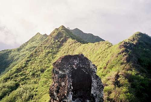 This is the north ridge of Rotui, at about 1/2 way to the summit. The summit is in the upper center of the photo and in the shadows.
Red Tape
No permits are required.When To Climb
July through September are the driest months and the best months for climbing. May and October are the second best months for climbing. April can go either way, but mid-November through March are very wet. This peak is extremely slippery during and after rain and should be avoided. The weather is always hot, so go prepared for that. Looking across the Opunoho Bay from the north ridge of Rotui in November.
Camping
Camping Nelson and Moorea Camping are located near each other on the northwest corner of the island. There are several budget (by French Polynesia standards) not far east of the trailhead. We stayed as Fare Oa Oa.All of the well-known hotel chain places to stay on Moorea are very expensive, especially if you do not book at home on a packaged tour.
In addition to camping, and for those travelers who wish for budget accommodations, and who wish to move about the islands more independently, below is the most comprehensive link to those types of accommodations:
GUEST HOUSES AND PENSIONS ON MOOREA
Mountain Conditions
Below is the weather forecast for Papeete, which is just across the channel and in Tahiti. This is the closest weather link you will find to Mouaputa. The mountains are quite a bit wetter and a little cooler than Papeete.CLICK HERE FOR PAPEETE WEATHER FORECAST
Below is the average climate chart for Papeete. Temperature values never stray much from average, but precipitation values do.
| MONTH | HIGH | LOW | PRECIP |
| JAN | 86 | 74 | 12.4” |
| FEB | 86 | 74 | 9.2" |
| MAR | 87 | 74 | 7.9" |
| APR | 87 | 73 | 5.7" |
| MAY | 85 | 72 | 3.6" |
| JUN | 84 | 70 | 2.4" |
| JUL | 82 | 69 | 2.4” |
| AUG | 82 | 68 | 1.9” |
| SEP | 83 | 69 | 1.8” |
| OCT | 84 | 71 | 3.6" |
| NOV | 85 | 72 | 6.4" |
| DEC | 85 | 73 | 12.5" |