
|
|
Mountain/Rock |
|---|---|
|
|
37.38656°N / 118.78521°W |
|
|
Hiking |
|
|
Summer |
|
|
8085 ft / 2464 m |
|
|
Overview
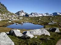
Mount Abbott is located just southwest of Rogers Pass in southeastern British Columbia. Part of the South Selkirks, the mountain is contained within Glacier National Park, a stunning park that is every bit the sight as its so-named counterpart in the United States. Only a couple/few miles west/northwest of Mount Sir Donald (and its 50 North American Classics route, the Northwest Ridge), this minor peaks offers fantastic views of Sir Donald, substantial glaciation to the immediate south, as well as The Rampart, Mount Afton and dozens of other aesthetic peaks that I cannot name. With about 3,200 feet of gain and a roundtrip of 7 miles, Mount Abbott is a pleasant class 2 hike that is most worth doing for the incredible scenery found along the way. The summit views aren’t horrible either! Mount Abbott can be readily linked up with its close neighbor to the west, Mount Afton (class 4).
Getting There
The Trans-Canada Highway runs through Rogers Pass between Revelstoke and Golden, some 4 hours from the international airports in both Calgary, Alberta and Kamloops, British Columbia. The pass, which sits at 4543 feet, boasts a gas station and convenience store, a Best Western ($150/night in July 2007) with a reasonably priced but so-so buffet after 5:30 PM, and a visitor’s center. The trailhead for Mount Afton is located 1.2 miles west of Rogers Pass. If coming from the pass, turn left on a paved road signed for the Illecillewaet Campground. The campground is adjacent to the trailhead. Drive about a half mile in. There’s parking for some 20-30 vehicles.
Red Tape
National Park Passes are required for all vehicles stopping in the park. These passes can be gotten from the visitor’s center at the pass. As I recall, the passes are a touch pricey, about $17 or so a day. Backcountry Wilderness Passes are also required for individuals camping in the backcountry.
Camping
Beyond the obvious comfy stay you can get at the Best Western, a number of campgrounds also inhabit the area. Closely, one can choose to stay at the aforementioned Illecillewaet Campground, or the Wheeler Hut (call the ACC at 403-678-3200 to book a spot in the hut), both of which are a 2 minute walk from the trailhead.
When to Climb
Though winter/off-season ascents might be reasonable, the optimal time to climb Mount Afton would be high summer, that being late July to early September.
Wandering Sole Images - Sep 9, 2011 11:50 am - Hasn't voted
Wrong coordinatesYour coordinates have the mountain down in Arizona.
gimpilator - Nov 29, 2015 1:02 pm - Hasn't voted
Coordinates GlitchAs Hulio has also noted, a strange glitch has corrupted the location of numerous pages and listed them all at the same point in southern AZ, USA. Please fix the lat/lon coordinates of this page to the following (51.236345, -117.508949) and I'll be happy to remove my "needs updates" vote. Thanks!