
|
|
Mountain/Rock |
|---|---|
|
|
49.02363°N / 113.96976°W |
|
|
Hiking |
|
|
Spring, Summer, Fall, Winter |
|
|
8832 ft / 2692 m |
|
|
Overview
Mount Alderson is one of the many rugged, windswept peaks located within Waterton Lakes National Park of Canada. Waterton, in the southwestern corner of Alberta Canada, is a non-commercialized, beautiful piece of nature. Home to lofty mountain peaks, crystal-clear lakes, a superb variety of plants and animals, and calm gently rolling prairies, Waterton is a nature lover’s dream-come-true.Mount Alderson lies at the south end of the park approximately 1.5 miles from the 49th parallel (the border between Canada and the USA). As with all the mountains in this astonishing area the views, in all directions, from the summit, are truly breath-taking. To understand just how amazing the scenery is see Jonathan Skrimshire pictures here and here. To the east is Bertha Lake. To the north is Alderson Lake. To the west is Cameron Lake. To the south are the numerous lakes and mountains of Glacier National Park, Montana.
Mount Alderson is clearly visible from the Waterton Townsite. Located 5.4 km, as the crow flys, to the southwest at 235.8 degrees from the intersection of Windflower Ave and Cameron Falls Drive.
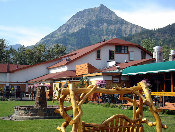 Mount Alderson is clearly visible from the Waterton Townsite. (Above image is displayed from Picasa and belongs to Mark Trego) |
History
The esteemed topographical surveyor and founding member of the Alpine Club of Canada, Mr. Morris Bridgland, gave Mount Alderson its name in 1915. Named after the senior British Army officer Sir Edwin Alfred Hervey Alderson (April 8, 1859 –December 14, 1927).E. A. H. Alderson is credited with helping lay foundations for the Canadian Army victory at Vimy Ridge during the First World War. Also see Vimy Peak.
Getting There

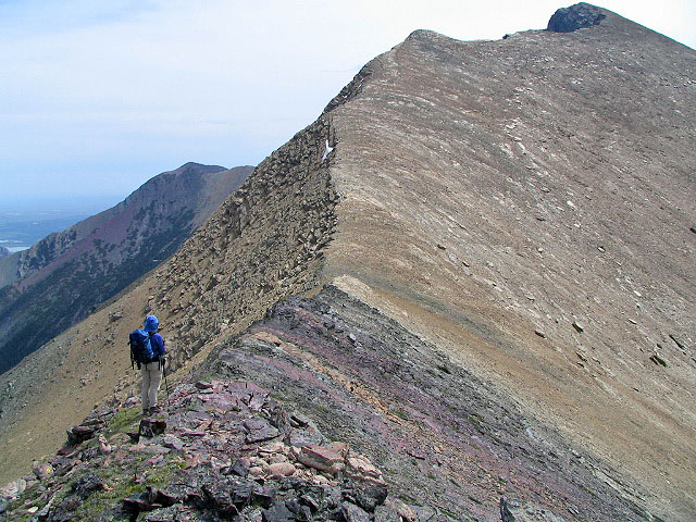
The rising west ridge of Mt. Alderson as seen from Mt. Carthew.
(Above image is displayed from and belongs to bobspirko.ca)
(Above image is displayed from and belongs to bobspirko.ca)
Mount Alderson is located in Waterton Lakes National Park in Alberta, Canada. This Park is situated 270 km (162 miles) south of Calgary, Alberta, 43 km (27 miles) west of Cardston , Alberta , and about 80 km (48 miles) from the St. Mary entrance to Glacier National Park, Montana. When driving to Waterton Lakes National Park it can only be accessed from its eastern side.
From Calgary take Highway 2 south to Fort Macleod, then west on Highway 3 to Pincher Creek, then south again on Highway 6. The drive requires about three hours.
From Cardston take Highway 5 west, through the village of Mountain View. The drive is less than 45 minutes.
From Glacier National Park, Montana, take the Chief Mountain International Highway (closed in the winter). From the St. Mary entrance of GNP it is approximately a 1 hour drive. In the winter take Montana Highway 89 to Alberta Highway 2 to Cardston, then Highway 5 to Waterton.
Finding the trailhead
There are a couple of different places to start this hike from both of which use the Carthew/Alderson hiking trail.
The most popular option is to start at Cameron Lake located at the termination of the Akamina Parkway. From the Cameron Lake parking lot follow the Summit Lake trail SE 4 kilometers to Summit Lake. From Summit Lake take the Carthew/Alderson trail NE, for about 3 km, to the ridge between Mount Carthew and Mount Alderson. See the routes section below for more information. The Akamina Parkway (aka Cameron Lake Road) is the first right off of Highway 5 immediately after you pass the left hand turn off for the famous Prince of Wales Hotel, about 1 km (0.6 miles) shy of the town. It is 16 kilometers to the end of the road.
The second option is to start at Cameron Falls located on Evergreen Avenue on the west side of the Waterton Townsite. Follow the Carthew/Alderson hiking trail 6.8 kilometers west to Alderson Lake, then another 2.4 kilometers to Carthew Lake. From Carthew Lake continue on the trail up, about another 2 kilometers, to the ridge between Mount Carthew and Mount Alderson. See the routes section below for more information.
One might also consider climbing Mt. Alderson as a detour on a through hike from Cameron Lake to Cameron Falls (or vice versa). Local businesses are rumored to provide shuttle services to Cameron Lake for a fee (contact the Park to find out more). The author has had good luck using the “free” shuttle service provided by pointing his thumb in the air at passing cars along the Akamina Parkway.
Routes
As mentioned in the Getting There section above there are a couple of different places to start this hike from both of which use the Carthew/Alderson hiking trail.Use the Carthew/Alderson hiking trail, either starting at Cameron Lake or Cameron Falls, to gain the ridge between Mount Alderson and Mount Carthew, this is the high point on the Carthew/Alderson trail located on Mount Carthews south shoulder. Roughly, from Cameron lake one can expect to reach the trails high point within 2 hours or so of hiking, expect more time when starting at Cameron Falls. From this point leave the trail and head eastward along the rising west ridge which will lead you to the peak of Mount Alderson. At first stick to the right side of the ridge on the red colored rock and dirt. Overall you will gain elevation, but there are a couple of steps in the ridge requiring short descents. The first step is best navigated on the left (north) side, whereas the second step is better negotiated by down climbing shale covered ledges on the right (south) side. You will first encounter a false summit before attaining the true summit. Experienced scramblers should be able to climb the ridge within 2 hours from leaving the Carthew/Alderson trail at its high point. Return to the Carthew/Alderson trail by using the same course in reverse. See a panoramic view with Mount Alderson labeled and notice the long ridge extending west from the peak, as that is the route outlined above.
 False Summit Ahead. (Above image is displayed from and belongs to bobspirko.ca) |
Weather
The summers in the Mount Alderson area are brief with some hot spells (high 35*C/94*F). Winters are long and relatively mild (high 10*C/50*F), with occasional warm spells caused by Chinook winds. This area is often one of Alberta's warmest places in the winter, despite ample snow and temperatures that can occasionally drop as low as -40*C/-40*F.Wind is an obvious element of this area’s climate, and shouldn’t be ignored. Gusts of over 100 km/hr (60 mph) are common, but thankfully they occur mostly in the fall and winter rather than the summer. Note that gusts of over 150 km/hr (90 mph) have frequently been recorded in the area.
This area receives Alberta's highest average annual precipitation of 1072 mm (42 inches) per year.
Camping
There are 9 designated wilderness campsites in Waterton, and one of them is located at Alderson Lake.Non designated or random camping may be permitted in certain circumstances. Prior permission from a park warden is required and all wilderness camping regulations and fees apply. Fires are not permitted.
Reservations are available for wilderness campsites. A non-refundable reservation fee is charged (see below), plus a modification fee for any changes. Reservations may be made 90 days in advance. Call the visitor center at (403) 859-5133.
As of January 31, 2012 Backcountry camping fees are as follows. Overnight, per person $ 9.80. Season, per person $ 68.70. Reservation $ 11.70. Can anyone say “rip-off”?
All fees are Canadian dollar rates.
Red Tape
In the spring, summer, and fall, one must pay an entrance fee in order to get into Waterton Lakes Park. There is no fee in the winter. As of summer, 2011 the Canadian dollar daily rates were $7.80 per adult or $19.60 for a family/group. Click here for the most up to date rates.Also note the park has no gas or groceries available in winter.
When traveling to Waterton Lakes National Park from Glacier National Park in the US state of Montana one must be aware of the Canada Ports of Entry operating schedules. Chief Mountain port of entry is open seasonally (closed in Winter) from May through September and Carway/Peigan port of entry is open year round from 7:00 a.m. to 11:00 p.m.
External Links
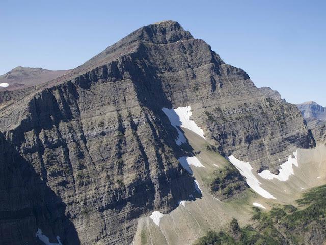
The East Face of Mt. Alderson in Waterton Lake National Park, Alberta Canada.
Mt. Alderson is typically climbed via it's long west ridge.
(The above image is displayed from Picasa and belongs to MtnNinja)
Mt. Alderson is typically climbed via it's long west ridge.
(The above image is displayed from Picasa and belongs to MtnNinja)
See a panoramic view with Mount Alderson labeled. Notice its long ridge extending west from the peak, as that is the typical route to the top.
A trip report with photos.