
-
 18063 Hits
-
 90.13% Score
-
 31 Votes
|
|
Route |
|---|---|
|
|
48.60050°N / 113.723°W |
|
|
Mountaineering |
|
|
Summer, Fall |
|
|
A long day |
|
|
Class 3 |
|
|
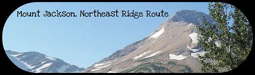
Layout designed for best viewing on a "1024 x 768" screen.
Mount Jackson stands at 10,052 feet above sea level and is the 4th tallest peak in Glacier National Park.
 A telephoto shot of the ridge from Going-to-the-Sun Highway, echoguy photo
Its nearest 10K plus neighbor is Mount Stimson which is located in the Nyack drainage.
Another 10k peak nearby is Mount Siyeh, Mount Jackson is considered more difficult to summit than Siyeh due to an overall total trip distance of nearly 18 miles and an elevation gain of just over 6,000 feet.
According to Jack Holterman in Place Names of Glacier National Park, Mount Jackson was named in 1891 by Robert Byrd Grinnell for William (a.k.a. Billy) Jackson who was a scout for Reno during Custer’s Last Stand. Reno’s battalion was not wiped out like Custer’s was.
According to Wikipedia, “Billy” also served with the Canadian Mounties as a scout during the “Reil Rebellion”. He was captured by the forces loyal to the Canadian government and was subsequently tried for treason only to be found not guilty by reason of insanity. After his trial he was incarcerated and then escaped from an insane asylum and managed to make it to the United States where he lived in Chicago and joined with others in labor protests and actually marched on Washington D.C. demanding an 8 hour work day. He must have been quite a character!
Ironically, to climb Mount Jackson in one day it takes more than an 8-hour workday as well as effort to climb around 6,000 feet, which includes elevation gain and loss from the Jackson Overlook trailhead to the summit of Jackson.
Route Statistics:
 Route Topo
 Elevation Profile
Total elevation gained on this Class 3 Route is an initial elevation loss of 640 feet from the Jackson Glacier Overlook on Going-to-the-Sun Highway to the trail junction near Reynolds Creek and then an elevation gain of 5,412 feet from Gunsight Pass Trail junction to the summit of Mount Jackson.
This total gain and loss of 6,052 feet does not include the numerous ups and downs on the trail from the suspension bridge on the St. Mary’s River below the trailhead to the suspension bridge at the outlet of Gunsight Lake.
If planning on doing this trip in one day expect a long day. Edwards suggests spending the night at Gunsight Lake and making this a two-day trip.
Views from the Summit:
Move mouse over photo for description. |  |
|---|
 |  |
|---|
Approaching Mount Jackson’s Northeast Ridge Route:
 Lake Ellen Wilson viewed from the route
Depart from the Jackson Glacier Overlook and travel 1.3 miles down to the junction with the Gunsight Pass Trail. Cross the suspension bridge over Reynolds Creek and follow the trail along the St. Mary's River for another 4.9 miles to the outlet of Gunsight Lake.
After crossing the suspension bridge, one person at a time, take a left at the obvious junction and follow that hiker’s trail for about 1 mile until crossing over the forested ridge below Mount Jackson. Beyond this trail lie the Blackfoot Glacier Basin as well as Mount Logan and Almost a Dog Pass as well as numerous other desirable destinations.
Special Considerations: The rock in Glacier Park is widely varied and it is not unusual to find several different types of rock on any given route. Know your rocks and be certain of your safety. J. Gordon Edwards has an excellent section in his guidebook on rock and climbing safety. Be safe and know your limitations as well as those who are climbing with you. Also refer to the following links for further details: GNP Rock and Grading System and the GMS Climbing Guidelines.
Northeast Ridge Route Description:
This route is described on pages 254-255 in J. Gordon Edwards book, A Climber’s Guide To Glacier National Park. (1) Beginning of climb from near climber's trail
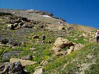 (2) Middle section of the NE slope
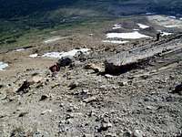 (3) End of Eas(ier) climbing
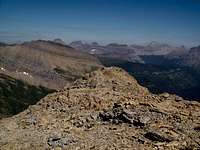 (4)Initial view from the ridge top.
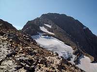 (5) Ridge Top
 (6) First break in ridge line
 (7) Interesting Rock Columns
 (8) View from the near the top of the route
 (9) The final traverse on the Harrison Glacier side of the ridge.
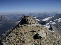 (10) Looking down the route from the summit.
After crossing the ridge begin looking up the slope for a logical place to begin climbing (see photo 1). The slopes actually open up and there are some nice sloped slabs that are interspersed with vegetation (see photo 2). Climbing through these lower is easily accomplished and is a good warm up for the upper (read: steeper) scree slopes that are yet to come. Keep working through these slopes by angling up to the left. Do not aim for the end of the ridge above, as it will require climbing up and down along the ridge to reach the beginning of the route instead aim for a point further up the ridge that is flat and appears to not have cliffs.
Be cautious to not knock rocks down hill on this route (see photo 3). Rocks travel fast on this hard packed rock/soil slopes. Climb together as a group and do not traverse above others.
After reaching the North ridge (see photo 4) the most difficult part of the climb is done. The complete route can be seen from this point.
Now it is a matter of finding and staying on the correct route (see photo 5). Most of the route takes place on the Gunsight Lake side of the ridge leading to the summit. There are only two areas that require class 3 or 4 climbing and the intervening portions are class 2 or 3 scrambling depending upon the chosen route.
From the ridge traverse on a goat/climber’s trail just below the ridge walk to the first break in the ridge (see photo 6). At this break the route continues on the Gunsight Lake side and the route is somewhat exposed but easily navigated until reaching a gully that requires the class 3 or 4 (depending upon the route) climb to continue up the ridgeline. There are numerous cairns along the route. If you find that you are off route retrace your steps and look for the cairns. The route generally stays within 30-50 feet from the ridge top.
Above this gully the route continues to follow scree filled ledges until reaching another more complicated climb that takes a sharp left and then right to regain the ridge (once again marked by cairns). This section has a lot of loose scree and it is crucial to protect those below you by moving one at a time through this section. There may be more than one route through these blockages so if you have extra time you can explore further along the northwest face.
After reaching the summit ridge again there are more of the scree filled slabs to climb.
Eventually this rock formation along the ridge (see photo 7) will be reached. It is here that the ridge proper is actually climbed rather than traversing below it. This continues until near the top of this slope as shown in the accompanying photo (7). It becomes obvious that you cannot easily walk along the summit ridge.
From this point on until the summit the route traverses below the ridge on the Harrison Glacier side of the ridge for the last 300 yards (see photos 8 and 9). The last few hundered yards are an enjoyable walk (See Photo 10).
The summit cairn is a group of rocks stacked up in a semi circular fashion and the summit register was found lying in the middle of the cairn.
If so desired read and sign the summit log then replace it for others to enjoy. There was no pen in the register.
Return Options:
Retrace your route back to the Climber’s Trail and return to the suspension bridge.OR
If there is a desire to have a change of scenery or decrease the risk of rolling rock consider descending on the northwest face of the ridge (see photo A) .
We had stashed our trekking poles and additional gear that we did not want to carry to the summit at the point where we met the ridge during our ascent. We could have chosen a different descent route if we hadn't needed to return to retrieve our equipment. The route suggested below is still to the west of the Northwest Slope Route described by Edwards.
 (A) Looking down the route from the ridge.
 (B) Beginning the descent of the NW Slope route.
 (C) Mid-way down the route.
 (D) Looking up the descent route.
The first step is to return to the point where the main summit ridge was first reached while ascending Jackson Northeast slope (see photo 4 in route section).
A good photo and suggested route down the Northwest Slope is provided in this linked photo. The suggested route down follows the red line.
Descend from the lowest point on the ridge towards the upper end of Gunsight Lake. While working across the scree fields continue angling towards the right through the intervening sets of cliffs (see photo B). The cliffs are easily navigated as well as loose scree in areas that are somewhat more enjoyable than the scree on the ascent route.
On the lower third of this large face is a pretty impressive hanging valley that would be quite challenging to climb through so avoid it by either staying on the scree fields to the left or right of the obvious gully that cuts into the scree field (see photo C). At the head of this hanging valley is an obvious deep gully that seems to suck all of the rocks and boulders that are accidently knocked loose during the descent.
Continue working through this massive scree field until reaching the Gunsight Pass Trail (see photo D). Obviously to return to Gunsight Lake you will need to hike down hill towards the lake. From this area it is about 2 miles back to the suspension bridge on the trail.
Follow the trail back to the Jackson Glacier Overlook trailhead.
Glacier's Shuttle System Information:
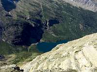
 Gunsight Lake and view on return route
The 2010 shuttle system runs from July 1 to September 6, 2010.
If desired there is a shuttle stop at the Jackson Overlook.
Glacier National Park began offering a FREE shuttle service in 2007. This is a great option for exploring the park. The shuttle runs the entire Going-to-the-Sun Highway from St. Mary on the eastern border of Glacier to Apgar, near Lake McDonald, on the park’s western boundary. Some climbs are close enough to the shuttle route and are short enough in time requirements to allow use of the shuttle service. Piegan is one such climb. The earliest shuttle’s depart from Apgar at 7:00 a.m. and generally take 1.5 to 2 hours to reach Logan Pass due to road construction on the West side of the Logan Pass. Trips from St. Mary are generally less lengthy and take an average of 60 minutes from St. Mary to Logan Pass. The first shuttle departs St. Mary at 7:00 a.m. The last shuttles depart from Logan Pass at 7:00 p.m.
The Park Service recommends being prepared to wait for shuttles with proper clothing, foot gear, water, snacks and other gear such as sun screen.
See the Glacier National Park’s web site for more information at Shuttle Service.
Essential Gear:
 Griz Scat with Fresh Huckleberries!
Trekking poles will aide in your ascent and descent while working through Jackson’s scree.
A GPS is also a useful tool to find routes during poor weather or when descending.
Consider bringing scree gaiters and extra water as well. There is adequate water along the trail portions of the routes. Bring a water filter if you are afraid of “Beaver Fever” (a.k.a. Giardia).
Carry bear deterrent spray. If you do not have any bear spray before getting to Glacier National Park purchase Counter Assault or UDAP at most local sporting goods stores. Both of these bear sprays are Montana Made products and are effective in deterring bears when used correctly.
As with all hiking and climbing in Glacier National Park use caution and practice good manners with the wildlife. You are in Grizzly country. Carry your bear deterrent spray, don’t hike alone and make some noise.
For more information please go to the Park's web site for Bear Information. The U.S. Forest Service also has helpful information on Grizzly Bear Management.
Guidebooks, Climb Registration, Links and Weather:
 View to the SE including 10,142 foot Stimson.
Guidebook: A Climber’s Guide To Glacier National Park; J. Gordon Edwards
You do not have to register for day climbs in Glacier National Park but it is recommended. Back country travel regulations can be found at Backcountry Travel. There is also information from the Park Service on Mountain Climbing in Glacier. Registration for climbing Mount Jackson can be accomplished at the Logan Pass Visitor’s Center.
Glacier National Park in Pictures
Glacier Mountaineering Society
