
-
 17887 Hits
-
 82.48% Score
-
 15 Votes
|
|
Route |
|---|---|
|
|
48.59540°N / 113.7101°W |
|
|
Hiking, Mountaineering |
|
|
Summer |
|
|
One to two days |
|
|
Some Class 3; Easy Snow |
|
|
 Jackson Glacier-- by sushiman
Overview
This trip takes one off-trail into a remote section of Glacier National Park nestled against the Continental Divide. The apex of the journey, a saddle above the head of the Jackson Glacier, overlooks some of the wildest country left in the Lower 48. Along the way, the work of glaciers is both visible and audible (blocks of ice break loose and crash down the mountainsides).
The 7853' saddle on the Great Divide at the head of the Jackson Glacier is an end unto itself and the primary focus of this page, but that end is just another beginning, as it offers access to rugged, wild, and challenging Walton Mountain and to Mount Jackson, one of the highest, largest, and most beautiful of Glacier National Park's peaks.
This trip can be done in a long day, but it is better to do as an overnighter. Gunsight Lake is a beautiful and convenient base from which to operate, and staying there at least two nights is virtually imperative if one plans to climb Mount Jackson or Walton Mountain.
The approach route follows one of the busier backcountry corridors in Glacier for six miles, but after that, the route enters remote and seldom-traveled terrain. Help is a long way away and may come too late if it comes at all, so leave a good trip plan behind with rangers and/or family, make sure you are fit and prepared, and don't go alone unless you understand and accept that the consequence of a serious accident may be death.
Getting There
Park at the marked Gunsight Pass parking area on the south side of Going-to-the-Sun Road, in the eastern part of the park. The parking area is about 13 miles from the St. Mary (east) entrance to the park, shortly below where the road begins climbing in earnest to reach Logan Pass.
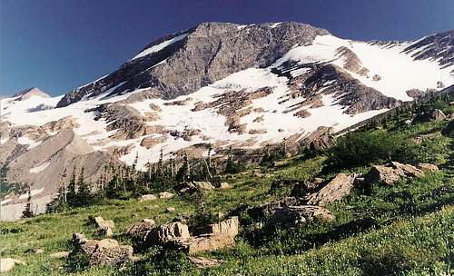
 View of Mount Jackson from near the trailhead
Route Description and Options
From the trailhead, follow the signed directions to Gunsight Lake. The 6-mile hike to the lake, which sits at 5350' with spectacular views of the surrounding mountains, is mostly easy, but the bummer is that it starts by losing about 500' of elevation (from approximately 5300' to 4800') during the first mile, which makes for a pretty crummy finale to the hike out.
There is a bridged crossing of Gunsight Lake's outlet, and the unmarked trail (but easy to find) to Jackson Glacier Overlook begins a few yards beyond the bridge. The trail, which lasts for about 1.5 miles, climbs steeply through a dense stretch of trees (hiking alone through here at dusk, just waiting for a grizzly to pop out, is unsettling) before leveling out as it breaks into open terrain near timberline. Directly ahead is a sublime view of peaks and glaciers along the Continental Divide. Notable sights are Mount Logan, Blackfoot Glacier, and Blackfoot Mountain.
 Head this way...
The trail eventually disappears, and maps say it ends at about 6000'. What drew me onward and eventually all the way up to the end of this route was the fact that, as awesome as the scenery was, I was not close enough to all those glaciers. The expansive snowfields south and southwest of you are technically the Jackson Glacier, but the glacier's standout features, its exposed crevasses and bluish ice, are not visible from the trail.
Continue on through a rocky landscape that is likely to be very slick from dripping snowmelt; the hiking turns into more of a scramble as you find yourself sidehilling along the wet terrain. Getting close to the crevasses, which are in a defile creating what resembles a gorge of ice, means a stream crossing that can be difficult and dangerous. But if the Continental Divide above the glacier is your sole target, you can skip this stream crossing by heading straight up the mountainside.
The rest of the trip entails about 1800' of elevation gain in 1.5 miles. Head up the snowfields, testing conditions as you go, and stay away from the crevasse-laced defile to your left and out of the path of the boulders of ice falling from Mount Jackson's upper slopes on your right (these boulders, and their "wakes," are readily visible in several places, and you will probably hear their thunder-like crashing as well; I remember hearing them and at first wondering what was going on, as the skies were clear at the time and had been all day).
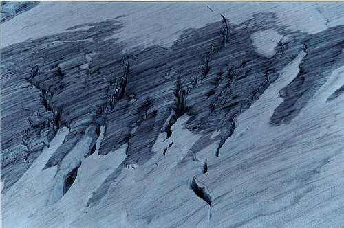 Crevasses of Jackson Glacier
Finally, you reach a 7853' saddle on the Continental Divide. Before you are the Harrison Glacier and horn-like Walton Mountain, occupying a setting of pure wilderness-- no maintained trails climb into this area. Breathe in the wilderness air and take some time to appreciate this special place; few others ever behold such sights. You are within the wild heart of the world here.
 Last stretch-- by sushiman
From the saddle, it is only about a mile to the summit of Mount Jackson, but that involves 2200' of elevation gain still. I have not found any information on climbing conditions from this point, but other routes on Jackson go at Class 3 and 4 with the possibility of steep, hard snow making things more difficult. One of the published routes up Jackson begins near the end of the Jackson Glacier Trail and attains Jackson's northeast ridge. Walton Mountain is a bit further away and involves glacier travel and technical climbing. It would be irresponsible for me to say any more about either climb since I have not yet climbed either peak.
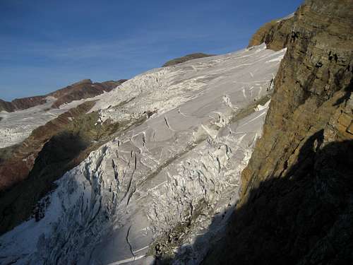 Harrison Glacier from Point 7853-- by sushiman
Essential Gear
I did this route in early July and was fine with hiking boots and trekking poles, but I wished I'd had an ice axe instead (the decision to head past the end of the trail and up to the head of the glacier was a spontaneous one). It wouldn't be a bad idea to have crampons, especially earlier in the summer. I encountered a few icy spots, but nothing I couldn't get up or around with what I had.
Because this is grizzly country, travelers should strongly consider carrying pepper spray. Make sure you know how to use it before you hit the trail.
Climbers wanting to continue on to Mount Jackson or Walton Mountain may want to consult J. Gordon Edwards's A Climber's Guide to Glacier National Park for route information. Neither peak currently has a page on SP.
Camping and Lodging
Consider staying at least one night at Gunsight Lake (3-night stay limit). Reserving a site is strongly advised.
Backcountry camping information
If doing this as a day trip, you can camp at St. Mary or Rising Sun Campground (sites can be reserved at the former, more information available through the park link). But it would be nicer to stay at the Rising Sun Motor Inn, which is a short drive from the trailhead.
Lodging information
 Or just camp up here-- by sushiman
Red Tape
It now costs $25 for a week's entry to the park.
This is prime grizzly country, so exercise due caution.
GNP Link
Link
Route Map
