Day One - Movin' On Down To Oregon
Standing at 10497' elevation, Mount Jefferson is the highest point of Jefferson County & Linn County as well as second-highest peak in Oregon. This was a great summit trip and is one of my favorite trips of the year. I was accompanied by Josh & Michael. They were each on their "A" games for this trip and I was really impressed. They both have gained so much experience and skill during the past 6-1/2 years I have known them. Everyone on our team was very laid-back and easy-going throughout the trip, and that made the experience even more enjoyable.
We left late Thursday afternoon and fought terrible traffic heading south through Pugetopolis gridlock in Washington State. In the middle of the night, we eventually reached a Rest Area between Mill City and Detroit in Oregon. Josh & Michael opted to sleep under the stars... or rather under a tree under the stars. I, on the other hand, opted to lounge back in the comforts of the front seat of my passenger vehicle. I thought the most interesting thing about this Rest Area was that it had a PRINGLES vending machine... I had never seen that before.
![Rest Area Naptime]() Napping at Rest Area
Napping at Rest Area![A Pringles Vending Machine?!]() A Pringles Vending Machine?
A Pringles Vending Machine?Day Two - Movin' On Up The South Side To High Camp
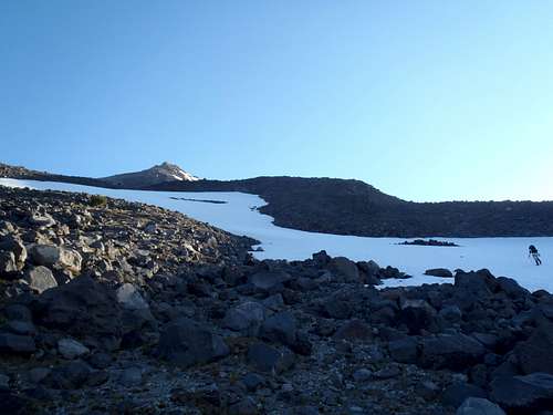
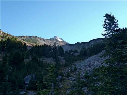
We headed out in the morning, taking a brief stop at a market in Detroit, before continuing to the Woodpecker TH. This TH has the disadvantage of a slightly longer approach than the Pamelia Lake TH, but with the advantages of not needing a special permit as well as starting at a higher elevation. We had a low-key agenda for the day: Hike the Woodpecker Trail & PCT to Shale Lake and then head up to high camp. That was it for the entire day! It was quite a leisurely itinerary when compared to most of our outdoor trips.
![Woodpecker TH]() Woodpecker TH
Woodpecker TH![Entering Mount Jefferson Wilderness]() It Just Got Real
It Just Got RealThe PCT is reached within 1.8 miles. Then Milk Creek is crossed approximately 1.7 miles further. Although Milk Creek is a water source, it was quite silty. Approximately 0.1 miles further is the Pamelia Lake/Hunts Creek trail junction, where we continued left along the PCT. After about 4.5 miles further, we reached Shale Lake... which was mostly devoid of water. And what water was there had little near-microscopic organisms swimming around. Yuck. We were told by a passing hiker that the next lakes were better but we did not want to go any further than necessary. Instead, we each laid down beneath a small grove of trees and napped off-and-on for the next 3-4 hours. As I said, we had a leisurely itinerary.
![Crossing Milk Creek]() Crossing Milk Creek
Crossing Milk Creek![Shale Lake]() Shale Lake
Shale Lake![Let s nap an hour... or four...]() Naptime!
Naptime!![Jefferson from Shale Lake]() Peak View from Shale Lake
Peak View from Shale LakeAt about 6:00 PM, I looked at my watch and said we had to get going if we were to make it to a nice high camp. I guessed we napped a little longer than we had planned. Anyway, what you do is simple. As you approach Shale Lake, turn left on a trail immediately prior to reaching the lake. Follow the trail until reaching a pair of tiny meadows with a small hill-island separating them. The trail leading to the south ridge can be picked up just on the other side of that hill-island, or if you just walk around the hill-island and find the trail on the other side heading up the tiny ridge. The trail is in excellent condition and looks heavily used.
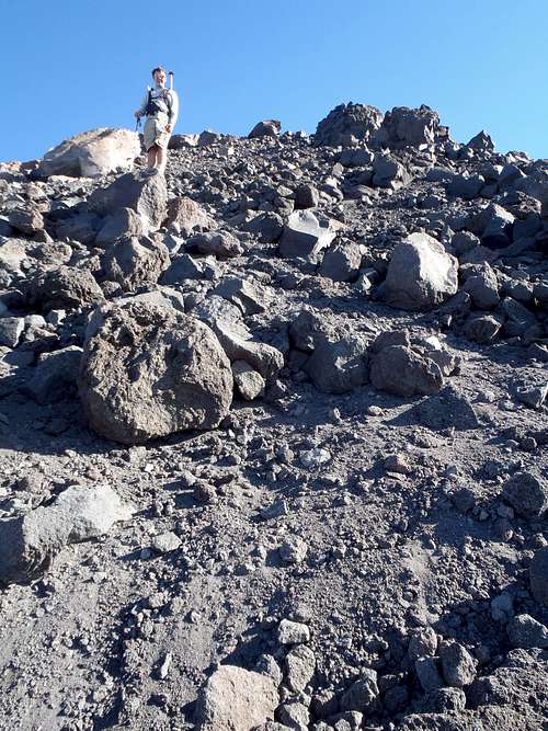
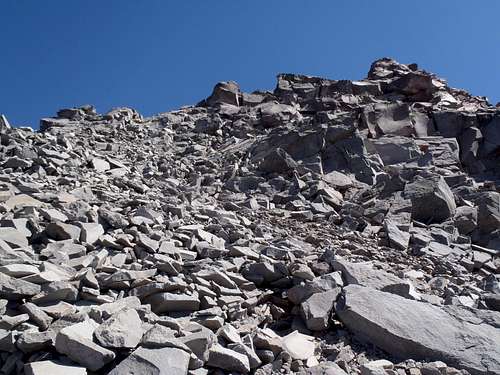
We followed the trail up forested slopes, across several meadows, and up scree/meadow slopes until reaching a boulder field. Once at the boulder field, I recommend boulder-hopping around the left-middle to go around a low basin and then get to the scree-meadow slopes on the right side of the boulder field. A scree trail side-traverses the slope, paralleling the boulder field.
The scree trail leads to a col east of Point 7818. From the col, we turned left and ascended to the hill above... basically near the unofficial beginning of the south ridge. We followed the ridge northward for a relatively short distance and found a krummholz basin (~7800') with multiple great potential campsites. We set up what we thought was a great campsite just prior to sundown. We found running water nearby from a snowmelt stream, a welcome sight.
![Crossing an alpine meadow]() Crossing Alpine Meadow
Crossing Alpine Meadow![Jefferson Boulder Field]() Entering Boulder Field
Entering Boulder Field![Jefferson Boulder Field]() Exiting Boulder Field
Exiting Boulder Field![Jefferson High Camp]() High Camp
High CampOne side of our tent had large boulders next to it, which we hoped would shelter our tent from a lot of wind. No such luck. The wind that first night was surprisingly swift, lifting our rainfly/cover throughout the night and almost making the tent seem like it would fly away at times. The wind would wake us up multiple times throughout the night, so we slept in a little the next day. After all, we only had ~2700' to reach the summit... How long could that possibly take?
Day Three - Movin' On Up The South Side To The Summit
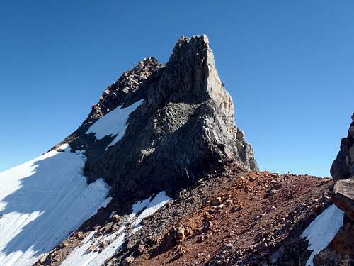
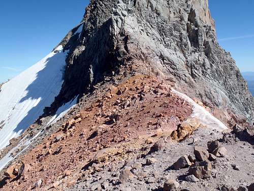
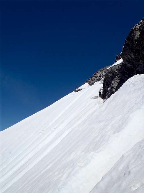
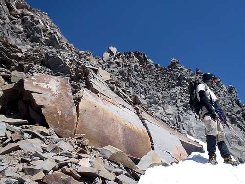
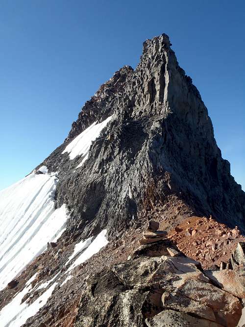
We left high camp on Saturday morning, ascending a combination of snow slopes, boulder slopes, and scree slopes. The scree was not as bad as any of us expected, although loose rocks would unexpectedly dislodge from foot and sand vibrations from time to time. Atop the South Ridge, we did a final scramble where we had a great view of the Red Saddle on the other side, the sometimes-terrible snow traverse beyond it, and the two peaks atop the mountain. The Red Saddle is appropriately-named, with red streaks of sand, scree, and rocks seemingly everywhere on it. We took a short break at the Red Saddle to prepare our climbing gear for the snowy/icy traverse of the upper west slopes.
![Jefferson from High Camp]() Peak From High Camp
Peak From High Camp![Josh on Jefferson Rubble]() Josh On Crumbly Scree Slope
Josh On Crumbly Scree Slope![South View from Jefferson]() South View During Ascent
South View During Ascent![Mount Jefferson and Red Saddle]() Jefferson and Red Saddle
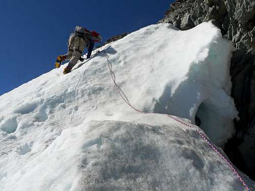
Jefferson and Red SaddleMount Jefferson is well-known for this traverse of the upper west slopes. In early-to-mid season, there might be so much snow/ice present that it requires a very steep and exposed side traverse. In late season, there might be so little snow/ice present that a dangerous loose scree side-traverse/scramble is necessary. Fortunately, we reached the traverse just as a moat was opening up above the snow slope.
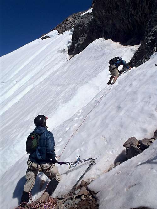
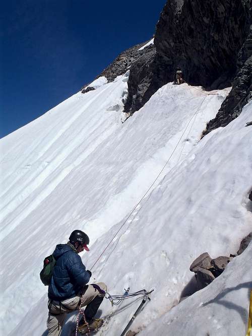
This moat might have opened only recently, as people who had visited earlier during the week traversed across the upper-middle of the steep snow slope. We were able to take advantage of the moat, using it for most of the traverse. With that said, it was not always easy and we took a lot of extra time to analyze the conditions, gear placement, foot placement, etc.
![Red Saddle]() Red Saddle
Red Saddle![Josh, ready to lead]() Josh, Ready To Lead
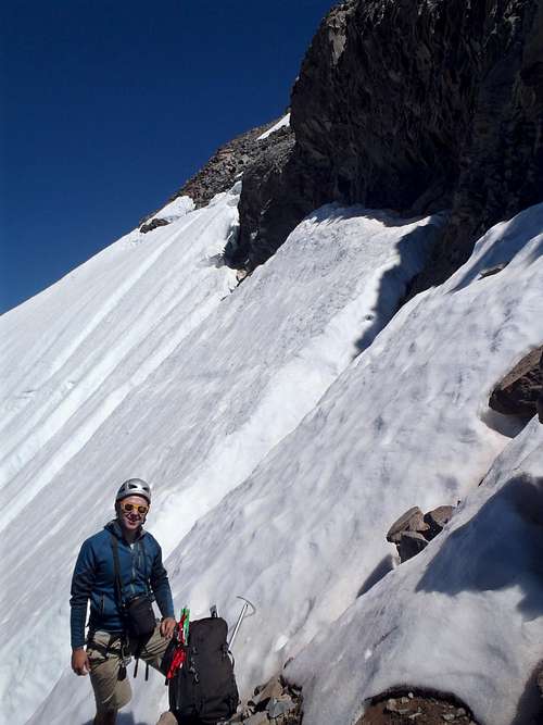
Josh, Ready To LeadThe entire west traverse might have been ~350' horizontal distance, perhaps longer with several ups and downs. We did it with two pitches using one 60m rope, three pickets (but we could have managed with two), and one ice screw (which was most helpful during the colder conditions for the ascent). The three of us communicated very well and took our time.
The time did not bother us, though, as we were trying to be as safe as we could for the conditions and we still had many hours of daylight to work with. By the time we were halfway across the first pitch, we noticed a wildfire start several ridges away to the southwest of the peak. We were probably the first people to spot the fire but had no way to call it in. Eventually, we reached a crumbly/rocky rib on the other side of the traverse.
![Josh leads, Michael belays]() Josh Leads, Michael Belays
Josh Leads, Michael Belays![Josh finds a moat]() Josh Reaches The Moat
Josh Reaches The Moat![Josh in a moat]() Josh In The Moat
Josh In The Moat![Michael across snow slope]() Michael, Across Snow Slope
Michael, Across Snow SlopeWe left our rope in place and no longer needed our harnesses. However, we kept our crampons and helmets on, and we still needed our ice axes for two more steep snow side/angle-traverses that led around to the north side of the peak. We took a short break at the base of a rocky scramble, and soon Josh started looking into the summit block approaches we had read about in previous reports.
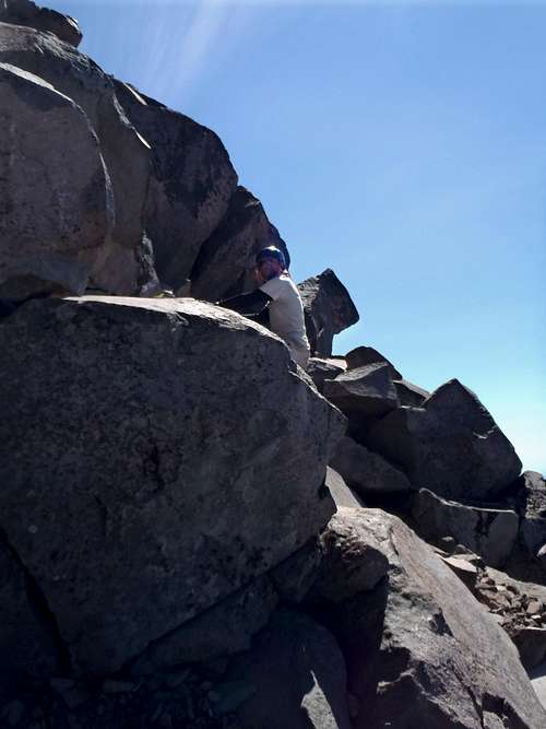
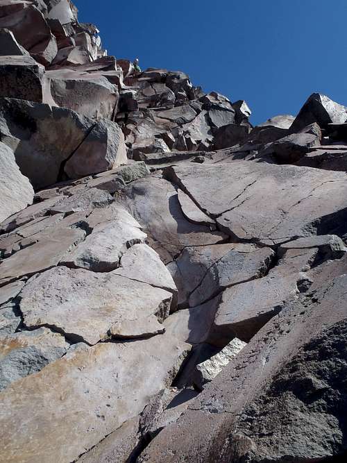
A few reports had mentioned a Class 3 route but most people have seemed to not find the easiest route. We found it. When on the north side, do not bother crossing around the north side to the east side where steep cliffs await you. Do not bother going straight up through chimneys or super-exposed climbs. Instead, side-traverse back southward along the upper west face of the peak
![Where s Josh?]() Where's Josh? (look closely)
Where's Josh? (look closely)![Michael Starting Jefferson Scramble]() "I expected this to be harder." -Michael
"I expected this to be harder." -MichaelYou need to look for a gully-like concave section full of solid rock... the most solid rock of the entire peak, IMO. Slightly climb up the left (north) side of the gully, walk across it, and then use a series of ledge climbs to the summit... crossing over to the south side of the gully rib near the top of it. The summit pinnacle is only a short distance away. From the summit, this route is not very obvious... but this route has to be hands-down the easiest way to climb this summit block.
I sometimes tend to over-estimate Class difficulty... such as calling something Class 4 when it might really be Class 3... but I honestly think our summit route was no worse than easy Class 3. No special gear needed; just hands and feet. Some exposure but nothing overwhelming.
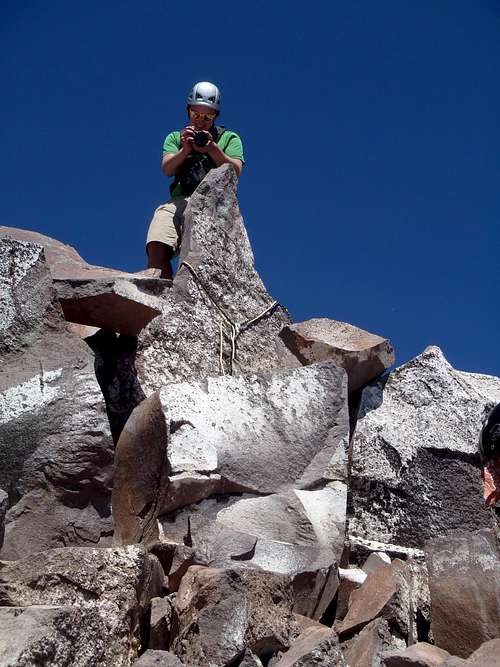
![Josh Above Jefferson Scramble]() "Almost there!" -Josh
"Almost there!" -Josh![Josh at Jefferson Summit]() Josh At Summit
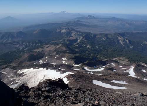
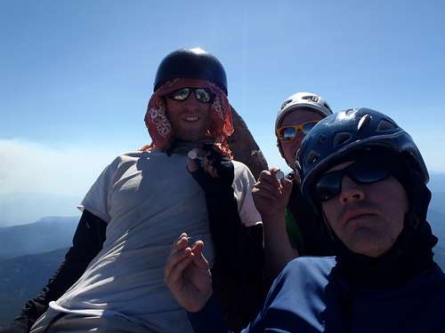
Josh At SummitWe celebrated the successful summit by each showing off nickels... which have President Jefferson on them. I also celebrated the summit with a dedication to my recently deceased peakbagging friend, Edward Earl, by eating a Pop Tart (one of his favorite summit treats) in his honor. This successful summit also meant I only had two more CoHPs in Oregon remaining to visit. The views were spectacular in every direction.
We could not help but continue to watch the progress of the wildfire we had seen blazing to the southwest of the peak. By this time, it appeared several helicopters were already in use to try to contain the fire. We also noticed two people heading down the glacier on the east side of the peak, perhaps having either timed-out or encountered dangerous/unpassable conditions (such as a gaping bergshrund).
![It s All About The Jeffersons]() "It's all about the Jeffersons."
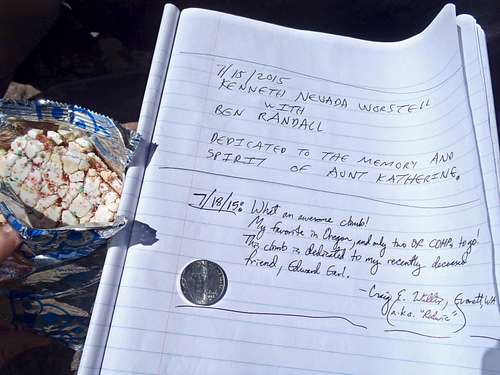
"It's all about the Jeffersons."![Mount Jefferson Summit Log]() Summit Log
Summit LogAfter a nice summit break, we headed down the same route. By the time we reached the snowy west slope traverse, the snow had softened considerably since our first climb across it. The ice screw was now useless. Although the softer snow allowed some sections to have better footholds, the softer snow also made some sections less trustworthy. Getting off the other side of the traverse tended to be the most cumbersome but still manageable with care.
While Josh and Michael handled some final gear-related stuff at the end of the traverse, I took the opportunity to scramble up the bouldery ridge above the Red Saddle to get a photo showing the two guys with the peak looming above them. This is probably my favorite photo of the entire trip.
![Climbing Mount Jefferson]() Me, Descending (Photo by Josh Lewis)
Me, Descending (Photo by Josh Lewis)![Last good view of Jefferson]() Last Good View Of Peak
Last Good View Of PeakOur descent back to camp was relatively quick. We got to take advantage of steep scree sand glissades as well as several snow glissades. We were each happy to reach camp with plenty of time for dinner and further socialization. We continued to watch the fire to the southwest, and we were happy that its large plume of smoke had dwindled down considerably (presumably from firefighters).
Day Four - Movin' On Down And Out
During that night following summit day, Michael and I saw something that was one of the most awe-inspiring sights I had ever seen. The night sky showed millions of stars and the Milky Way was easily seen. The wildfire had a bright, eerie red glow at a location where the Milky Way was rising from the horizon... almost as if the wildfire was releasing smoke that turned into the Milky Way. It was awesome to see. Perhaps you had to be there to envision it properly.
At approximately 1:30 AM that night, we were woken by a small team of climbers passing near our camp. I put on my sandals, turned on my headlamp, and called out to them, planning to give them some tips for the current conditions beyond the Red Saddle. We figured they had gotten a late start on their climb and were just searching for a high camp. Instead, they completely ignored us and continued heading up the peak. With so much loose rock and scree, and commonly-dislodged rocks and rockfalls, I thought it was not only negligent but also a little crazy to be climbing up the upper elevations of the peak in the dark.
But to each their own. We watched them sometimes go way too far left and way too far right, with their headlamps shining every which way, as they seemed to sometimes have difficulty following what would have been a straightforward route during daylight hours. If only they had stopped for a couple of minutes, they could have been led the right way or found some useful information for current route conditions.
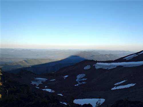
We tore down camp early on Sunday morning and headed down. We met two nice guys from Portland who were planning to climb the peak that day, and they seemed appreciative that we provided them with great beta for the upper sections of South Ridge approach. The hike back to the car was fairly uneventful, outside of the early morning being hotter than we would have liked.
![Jefferson Shadow]() Jefferson's Morning Shadow
Jefferson's Morning Shadow![Goodbye to Jefferson]() Farewell, Jefferson!
Farewell, Jefferson!During the drive home, we stopped for Mexican food in the town of Gates and then later stopped for shakes after getting back into our beloved State of Washington. When we drove by Portland the temperature reached 104 degrees(!), so it was not too surprising for us to see multiple wildfire smoke plumes during the drive home. Traffic was horrible, and the heat of the day was even more grueling during the longer-than-expected commute. But when we got back home, we were all smiles when thinking about our great trip.
Movin' On Up To The Statistics
MOUNT JEFFERSON:
Elevation: 10497'
Clean Prominence: 5777'
Peak Type: Volcano
Highest Point Of...: Jefferson County, Linn County, Willamette National Forest, Warm Springs Indian Reservation, Mount Jefferson Wilderness Area, Willamette River Drainage Basin
OUR TRIP:
Party Members: Craig Willis, Michael Lewis, Josh Lewis
Trailhead Used: Woodpecker Trailhead
Approach Used: South Approach from Shale Lake
Weather Conditions: Hot Days, Warm Nights, Calm Wind, Clear Skies (When Not Including Wildfire Hazes)
Terrain Conditions: Trail Hiking, Open Country, Stream Fords, Snow Walks, Exposed Scrambling, Steep Snow Climbing
Major Gear Used: Helmet, Ice Axe, Crampons, Harness, GPS, Map, Rope, Ice Screw, Poles, Tent
Roundtrip Distance: 25 Miles
Cumulative Elevation Gain (Roundtrip): ~8050' (including ~1000' Extra Gain)
Subjective Trip Quality: 10 out of 10


Comments
Post a Comment