
-
 19415 Hits
-
 84.82% Score
-
 19 Votes
|
|
Mountain/Rock |
|---|---|
|
|
38.13900°N / 105.714°W |
|
|
13340 ft / 4066 m |
|
|
Sangre de Cristo Overview
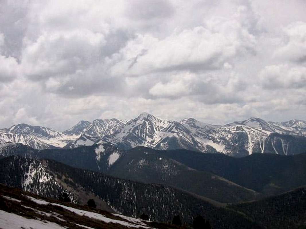
Above is Mount Owen amongst unnamed summits of the north-central Sangre de Cristos (Owen being the central prominenent point); as seen from Cottonwood Peak, May 2003.
 The Sangre de Cristo Mountains are a one of the most distinct subranges of Colorado's Rocky Mountains. They rise as a nearly continous straight line from near Salida, Colorado to Sante fe, New Mexico. They are seperated from adjacent ranges by the San Luis Valley on the west and Wet Mountain Valley on the east. The Sangre de Cristos are more rugged then their Sawatch bretheren to the north west and a distinct geology differentiates them from the San Juans to the west. The sharp peaks and solid sedimentary rock of the central Sangre de Cristos distiguishes it as a place like no other in Colorado.
The Sangre de Cristo Mountains are in large part protected by the 226,455 acre Sangre de Cristo Wilderness, designated in 1993; and the Great Sand Dunes National Park still undergoing political rangling prior to full park designation. Thanks is part to the legal protections granted by the Wilderness Act large portions of the Sangres remain relatively pristene.
- Sangre de Cristo Geology: The Sangre de Cristo Mountains are a Fault Block Mountain Range. Their history can be traced back to the Ancestral Rocky Mountains that rose as a chain of mountainous islands running roughly from the northeast to the southwest across Colorado 300 million years ago. As these ancient mountains were ground down by the forces of erosion, sediments carried off by ancient river systems built up large deposits in the Central Colorado Trough, a large basin between the Uncompaghre Highlands and the Front Range Highlands.
In the vicinity of the Sangre de Cristos a formation called the Crestone Conglomerate was the result of the erosion of these mountains. The conglomerate is an alluvial deposit of rounded boulders, cobles, and stones imbedded in a sandstone matrix, it was dropped by swift moving streams and rivers as they exited the mountains and entered a shallow sea. It is solid and erosion resistent. Contemporaneous sedimentary deposits compose the Fountain Formation, of Red Rocks and the Flat Irons, and the Maroon Formation of the Elk Mountains. These coarse deposits were subsequently burried by younger sediments. They laid deep underground for 235 million years.
Beginning 65 million years ago the Laramide Orogeny began thrusting sections of Colorado towards the heavens. Whereas the rock of the Sawatch and Mosquito Mountains to the north bent upward as broad curves, the Sangre de Cristos first bent, then broke along several faults. As the uplift pressed the core of the Sangres against the pre-existing Wet Mountains the resulting pressure thrust the Sangres westward. The same faults that pushed the Sangres away from the Wet Mountains reactivated 26 million years ago (as the Rio Grand Rift awoke dormant faults throught Colorado, and creating all the Great Mountain Parks in the process) dropping the Wet Mountain Valley and the San Luis Valley in relation to the soaring peaks. The rocks presently exposed range from the Precambrian basement rocks in the northern and southern (Sierra Blanca) portions of the range, the central sections are composed predominantly of 300 million year old Crestone Conglomerate, and 23 million year old intrusive stocks make up the Spanish Peaks.
Begining 1.8 million years ago and continuing up until 20,000 years ago, glaciation scoured the mountainscape. Headwalls were steepened, valleys broadened, and aretes carved. Evidence of the action of glaciers is evident from the presence of big u-shaped valleys joined by hanging valleys, often connected by small waterfalls as at Willow Lake. It is seen in on exposed rock surfaces polished and striated by the patient motion of mountain glaciers. Morraines, piles of material glaciers eroded from the surrounding mountains and dropped as a contoured wall of debris as the glacier receded from its last advance, choke many of the drainages of the Sangre de Cristos, requiring an ascent of a steep, loose hill on route to the upper basins. These same morrains often shelter high alpine lakes which occupy the broad basins and shelves the glaciers carved. The effects of this Ice Age artistry rendered the unique geology of the Sangres into the sculpted forms that exist today.
- Flora and Fauna: The Sangres system of narrow valleys seperated by rugged ridges creates a constrained ecology that seems well suited to the discreet little oasisses the occupy. The vegatative growth seldom shows the large old trees (except perhaps in the Heurfano River Valley) seen in the Elks or Front Range. The Aspen though, abundant are often small of girth and darker of bark then the massive apen stands of the Elks or San Juans. The high peaks are often decorated durring the summer months with a verdant velvet of grass that often grows in wonderful wave patterns dictated by the goelogy of the rock. The flora of the Sangres is interesting for its distinct differences...
The wildlife of the Sangre de Cristos is also worth mentioning as you cannot triapse around this range long without encountering its native denizens. Marmots, Pika, and Alpine Voles are abundant in all drainages. In areas where marmots have gotten used to people, they are to be feared. Cyotes and Pine Martins prey on these animals. Elk, Whitetailed Deer, Bighorn Sheep, and Mountain Goats are the large herbivores. Black Bears and Mountain Lions are also present. Precautions should be taken for storing food in a manner that won't attract the bruins.
Mount Owen Overview
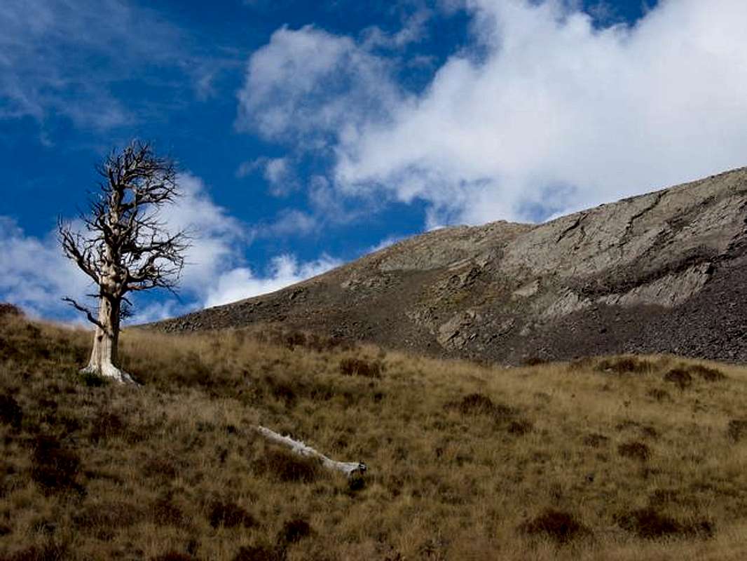
Mount Owens and "The Wizard Tree". Happy Halloween!
Mount Owen is on the western side of the North Central Sangre de Cristos. It is a handsome mountain with shapely north and east faces yet it has a gentle West Ridge that provides easy access to the summit. It is composed of the Crestone Conglomerate of Sangre fame which greatly adds to its allure. This beautiful and solid rock makes for some of the most enjoyable ascents I have experienced. The Wild Cherry Creek Route allows for an easy ascent up Mount Owen's West Ridge followed by an interesting and direct descent down Mount Owen's South Face which is festooned with boilerplate slabs and neat grassy pathways.
Mount Owen is a high named summit at the north end of a series of summits seperated from the Sangre De Cristo Range Crest proper. Parallel with the Sangres, from Mount Marcy South to Comanche Peak, there are 3 groups of lesser known thirteen-thousand foot summits set off to the west that represent some of the hidden joys of the Sangre de Cristos. From north to south are: Mount Owen and Unnamed 13,490 (seperated from the range crest by Cotton Creek), Unnamed 13,062, Unnamed 13,060 and Unnamed 13,028 (all three seperated from the range crest by Rito Alto Creek but connected by a saddle to Hermit Peak), and Unnamed 13,054 (seperated from the range crest by the North Fork of North Crestone Creek).
Mount Owen, as the sole named thirteen-thousand foot member of these western outliers is a good place to immerse oneself in this lesser traveled region of the Sangre de Cristo Wilderness. It abounds with a charm all its own.
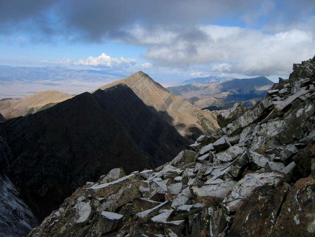
Mount Owens from the summit ridge of Peak 13,490 after a brief snow storm.
Getting There
The primary access points for Mount Owen are on the San Luis Valley side of the Sangre de Cristo. The two trailheads that provide access to Mount Owen are the Cotton Creek Trailhead and the Wild Cherry Creek Trailhead.To get to the Cotton Creek Trailhead drive 26 miles south of Poncha Springs on US 285. At the 285 CO 17 junction turn left to follow CO 17 for 6 miles. Look sharp for Saguache County Road AA. Turn Left and travel east on Saguache County Road AA for and additional 8 miles. Turn right at a road bearing a sign for the Cotton Creek Trailhead and follow it for 2 miles. Note: The Cotton Creek access is an alternate that has not been used by the page's author. However both the topo maps and the authors experience on the Wild Cherry Creek side lead him to believe viable routes exist from the Cotton Creek Trail on the north slopes of Mount Owens West Ridge.
The primary access to Mount Owen is provided by the Wild Cherry Creek Trailhead. This delightful trail is reached by driving 26 miles south of Poncha Springs on US 285. At the 285 CO 17 junction turn left to follow CO 17 for 6 miles. Look sharp for Saguache County Road AA. Turn Left and travel east on Saguache County Road AA for and additional 8.5 miles (past the turn off for the Cotton Creek Trailhead) to a well signed Trailhead with a decent sized parking area.
Red Tape
No Permits or Fees Required.Contact Information:
Saguache Ranger District (USFS)
46525 State Highway 114
Saguache, CO 81149
719-655-2553
When To Climb
With the low trailheads in the San Luis Valley and the relaxed nature of Mount Owen's West Ridge this mountain may be tackled year round as long as avalanche danger is low.In the Authur's opinion the Wild Cherry Creek drainage, with its extensive aspen stands and gurgling creek, would deliver the most memorable experience durring the shoulder seasons. The iradescent green of the Aspen in spring or the glorious golds of fall would make what is already a nice trek, absolutely devine.
Camping
On the Wild Cherry Creek side: There is limited camping available at the trailhead. Better camping is available 4.5 miles in at a pleasant meadow in the upper valley. Camping would also be possible near Peanut and Wild Cherry Lakes.Weather Forecast
For a detailed seven day forcast of the nearby town of Crestone, CO please click this link.