
|
|
Route |
|---|---|
|
|
59.18756°N / 135.38394°W |
|
|
Hiking, Mountaineering, Skiing |
|
|
Summer |
|
|
Most of a day |
|
|
Class 1+ |
|
|
Overview
For a small mountain, Mount Riley offers a variety of routes from several directions. Which route is best to take will depend on your time and mode of transportation as well as your choice of accommodation.If you are staying at say the Portage Cove Campground, you may prefer an out and back climb from the Beach Road/Battery Point Trailhead. If you are staying in downtown Haines without a vehicle, the best route is probably to walk to the Beach Road/Battery Point Trailhead and hike back to Haines via Lily Lake and the FAA Road. This will eliminate the three mile paved road walk from Mud Bay.
If you have your own car and don’t want to mess with a shuttle, hitchhiking or taxi, the recommended route to Mount Riley is from Beach Road/Battery Point.
Though this route is the longest of the normal routes, this is the most scenic of the trails to the summit of Mount Riley. It is 4.0 miles each way and offers a nice side trip to Battery Point.
 The summit of Mount Riley on a cloudy day.
Getting There
This trailhead offers what is probably the most scenic route up Mount Riley. From Main Street in Haines, head south on Third Avenue and turn left on the Haines Highway. Follow the highway east and south (the name of the highway will change to Beach Road) and follow the road to its end. This is about two miles from Main Street in Haines. Mount Riley (right) and a totum pole as viewed from Haines. The Beach Road/Battery Point Trailhead is near the left side of the forested point.
Route Description
From the trailhead, the trail heads south along the coastline for 0.9 miles. The trail to the right is the one heading up Mount Riley, but if time is available, it is recommended that you take the side trip to Kelgaya Point and Battery Point, which is a nice scenic beach location. If you choose to do the side trips, it is 0.3 miles each way to Kelgaya Point and another 0.6 beyond Kelgaya Point to Battery Point.After turning right (coming from the trailhead) at the junction near the coast, the trail to Mount Riley heads up the mountain west and then south. Along the way you will pass through a nice thick forest and past several interesting outcrops.
The trail gains the north ridge of Mouth Riley 2.2 miles from the trailhead where it more or less follows the north ridge to the summit, passing several muskeg meadows along the way. After 3.8 miles from the trailhead, there is a junction with the trail from Mud Bay Road. From here, turn left and follow the trail 0.2 miles to the summit of Mount Riley (4.0 miles from the trailhead).
If you have alternate transportation or don't mind hitchhiking, you might consider descending the trail to either Mud Bay or Lily Lake/Haines.
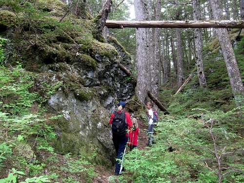 Climbing Mount Riley from Battery Point.
Essential Gear
A good pair of boots is needed. Southeast Alaska is notorious for bad weather, so go prepared for that.Also, since the topo maps don't show any of the trails on Mount Riley, try and pick up the publication Haines is for Hikers while in Haines.
The brochure is also available online below:
Haines is for Hikers