
-
 25269 Hits
-
 89.26% Score
-
 31 Votes
|
|
Mountain/Rock |
|---|---|
|
|
51.08196°N / 115.41687°W |
|
|
8497 ft / 2590 m |
|
|
Overview
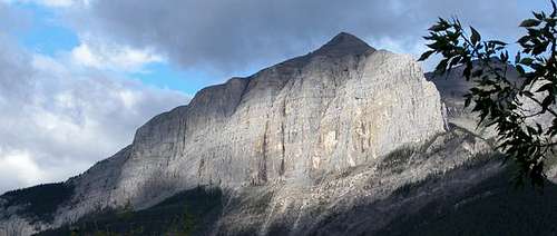
The Eastern end of Rundle as seen from Canmore, Alberta
The east end of this peak system with 18 summit points has a variety of routes to its summit. The normal route is one of the most traveled in the area. Overlooking Canmore Alberta, sees thousand of climbs a year. The trail is easily found and aside from the final 50 meters is more of a hike than a scramble. The easiest route is up the back slope. An approx. 3-5 hour round trip is what Alan Kane's Scrambles in the Canadian Rockies mentions as a return trip time. 2.5 hours is easily achieved with some time on the summit.
An excellent conditioning hike.
Elevation gain is 900 feet.
Getting There

The view east from the summit
From Canmore, Alberta take the Spray Lakes road past the dam, the Nordik Centre, through Whiteman's gap and park in the Goat Creek parking lot. This is easily found and is signed. It is about a 15-20 minute drive from the center of Canmore.
From the parking walk back up the road and look for a well-trodden route up to the left just past the second telephone pole. The Scrambles book mentions just past the "Bow Crow Forest" sign but it no longer exists. Just the old rusted frame. You will not miss the trail. It is an obvious one.
Red Tape

East Rundle in the clouds from Lady MacDonald
There are no fees or red tape. You are just outside of Banff National park.
When To Climb
Open all season except for Bear activity. The usual trail requirements. Stay on the trail to avoid erosion.
The summer months would be the best as the top sections could become slippery when icy or wet. Proper footing and gear would allow for all season climbing.
Mountain Conditions
www.weatheroffice.com or (403) 762-2088 for weather reports
As mentioned above Beware of the weather conditions and dress accordingly. Note there is some scrambling near the summit. If the weather turns these can ice up and people have injured themselves because they went up the slabs in nice weather then the slabs iced up in the snow or rain and made the route very dicey for the descent.
This route and many others are well described in the guidebook Scrambles in the Canadian Rockies by Alan Kane.
The Alpine Club of Canada
Joining a club such as The Alpine Club of Canada is recommended when climbing in Canada. While it is not obligatory, useful information can be had at any of their Clubhouse in Canmore, or at their website which is open to everyone.
http://www.alpineclubofcanada.ca/
Staying at the club in Canmore is 18$ Canadian for members and 19$ for non-members. It can get quite crowded in the summer so a reservation is recommended.
Banff/ Lake Louise
Try this for activities in the area
Banff Lake Louise Tourist Bureau