
|
|
Route |
|---|---|
|
|
48.77470°N / 121.2989°W |
|
|
Mountaineering |
|
|
Summer |
|
|
A few days |
|
|
5.0 (YDS) |
|
|
Overview
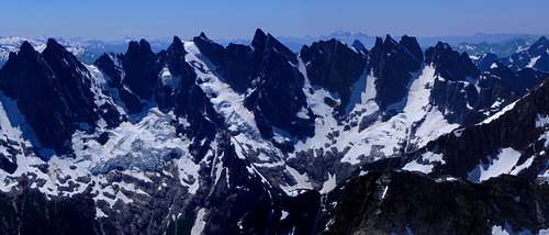
Southern Pickets, Mount Terror in center. This is *not* the side climbed on this route, but it does emerge at the notch right side of the peak.
This is the “easiest” route to summit Terror, and by that I mean least technical. It is still a trip of considerable physical exertion, and absolutely requires the North Cascades climber’s mindset. The approach alone requires almost 6000 feet of elevation gain over very rough and sometimes non-existent trail, and good overall navigational skills. Despite all this, I can highly recommend this as the perfect route for anyone looking for a climb with just a few short bits of rope-work to take it a step above simple scrambling, without extensive longer stretches of leading and belaying. It is also a great choice for an experienced soloist. And of course it gets you into the heart of the southern Pickets, one of the great places of the North Cascades, so the suffering is worth it.
Getting There
The drive: From Hwy 20 just west of downtown Newhalem, turn north on the road directly across from the North Cascades Visitor Center entrance road. There are also signs as you approach this intersection that point toward the turn with the caption “Newhalem Maintainence Facility”. After turning, you will immediately encounter a “T” intersection, turn left. Pavement quickly ends, go past a gravel quarry, then drive a few hundred yards until the road splits again, you go right uphill on a narrow but well graded road (no need for 4wheel drive or extra clearance). In about a mile or less the trailhead comes upon the right, can’t miss it. The park service tells me no parking permit is needed as long as you’ve checked in with them at Marblemount.
The trailhead on Goodell Creek is now “developed” with parking spaces and a sign warning that this is a climbers trail, not a regular hikers trail.
The walk: Hike the trail on old road bed for about 4.5 miles. Some of this is quite pretty, with moss covered ground and open forest, other spots sorta brushy. At the end, there is a rock cairn/arrow pointing to the hard right turn uphill to go to Terror basin. Nice as that trail looks, this unfortunately is not your turn, you go straight. Road bed ends here and the “trail” traverses a steep hillside. It gets hard to follow in places, but it is critical that you do your damned best to stay on it. Eventually, it will simply and completely disappear, but there is pink flagging to guide you through the forest and brush. When you come across the stretch of moss-covered car and truck sized boulders you will know you are still on track; the pink flagging is intermittent. Keep going, generally level then gradually descending toward Terror Creek, go slow and take time to seek out those flags. On the final descent to the creek, trail should definitely re-appear. If you arrive on the creek side without any signs of trail, make it your mission to go back and find it, I cannot stress how critical this is. When you follow this trail down to the creek, it drops through a side channel then up to a small tent size platform someone has scratched out of the gravel, right where trees give way to open river gravel. You can tell this tent platform has been there a long time because moss is growing amongst these rocks. This is an important location spot to guide you to the next critical juncture. From this old tent site, step over the logs and rocks piled up at the edge of Terror Creek’s main channel. Look straight across the creek at the opposite steep hillside, there is patch of fern-covered ground there with no trees for about 30 feet above the creek. You can’t see it yet, but there is a climbers track ascending right there, and without finding this, you are unlikely to make it up to Crescent Creek basin, at least not in a single day. Mark that spot in your mind, then turn to finding a way across the creek. Last time I was there the only serviceable log for crossing with dry feet is a couple hundred feet upstream. Then come back to the open spot on the steep hillside and find the climbers track up. It is an amazing trail, weaving back and forth between moss-covered cliffs, finding surprise ledges, and plowing straight up wherever possible.
1600 feet later you will arrive on the crest of the barrier ridge where the trail will essentially disappear. Just apply your off-trail travel skills and head up, travel is not particularly difficult, in fact kinda fun in places. I recommend staying close to the ridge even after hitting timberline, avoid the temptation to angle out into Stump Hollow too soon as hidden out there are a bunch of mini-canyons forcing annoying detours and route-finding. It goes much smoother to wait until you are almost level with the ridge at the top of the hollow, then turn left and head over to the ridge.You can camp right on the ridge, or drop into Crescent Creek Basin and camp up closer to the base of Mount Terror; there are a couple of good smoothed-out tent sites in both locations.
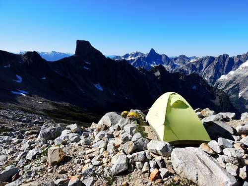
Crescent Creek Basin basecamp
Route Description
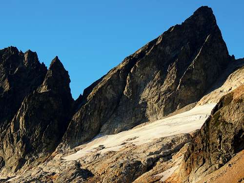
Mount Terror above Crescent Creek Basin
After making the trip up into Crescent Creek basin, head for the obvious slot.
The slot on the Crescent Creek side of Mount Terror. Intentionally overexposed to show some detail deep in the shadows.
Earlier season will have some snow providing easier ascent. If late season and snow-free, it is still very doable, just be prepared for a few low 5.easy moves in a few bottle necks. Low down the slot splits, go left. Up higher, hug the left wall along a dirty ledge and over a dining room table-sized boulder, then the final yards to the notch on moderately steep gritty crap. It’s actually not too bad, just a little unpleasant, and loose enough that descending encourages a rap.
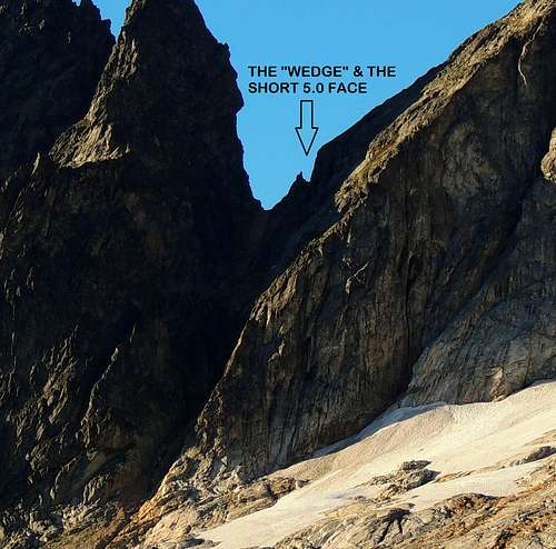
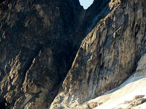
Telephoto shot of the notch on Mount Terror's west ridge
Now at the notch: First of all there is a 50 foot tall wall, flake, or wedge blocking direct access to the west ridge. When you are here makes a difference in how to get around this. Earlier season the space behind this wedge and the vertical face that begins the west ridge is packed with ice. In that case it is probably best to climb right up over this wedge then drop behind. The climb up is easy, the drop behind awkward but manageable. Later season the north face ice has retreated a little, and you can drop down north from the notch about 10 feet, walk in the moat about 15 or 20 feet east, to circle behind the wedge of rock that blocks direct access to the west ridge from the notch. Once behind this wedge, you are facing the crux, very steep rock. It is low class 5, following a crack. A piton or two is helpful here. Once on the actual rock face, angle climber’s left along a crack to the obvious rap station above, adorned with several pounds of slings. You can see this station/sling collection from down at the notch. Above this a flake allows easy slinging, a few moves slightly right but mostly straight up delivers one to suddenly easier ground. You can go off belay for considerable hiking/scrambling now, but take the rope in case you’d like a rap or two from the summit tower.
There is a little bit written about going onto the north face to find a 4th class route. I’ve been up here in earlier season and later season. Earlier there is considerable ice stuck to this face making the trip around sorta tough. Later season it just becomes plain exposed. The slabs there on the north face do not look inviting, as in class 4 inviting, to me. Rather, straight up from the notch (after getting around the aforementioned wedge/flake) is much more inviting, in fact rather enjoyable. But maybe it is a matter of personal taste. So keep in mind my route description does not include this supposed north face 4th class deal.
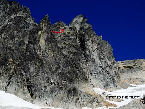
Despite the very vertical appearance, the slot cuts right through. I have added a red line up high showing where one emerges after the short vertical face climb and walks to the grassy ledge to turn the corner.
Once above the notch, the summit tower is not in view here. Probably everyone who climbs this route heads up to the false summit visible above, only to discover themselves cut off from the real summit by some trickylooking down-climbing. And the summit tower looks rather intimidating from the false summit. So, instead of going that way, when you climb up out of the notch, simply turn south, and walk a hundred feet on a slightly rising traverse, turn a corner on a grassy ledge, and then the true summit comes into view. An easy scramble up a grassy gully leads to the notch between the false and real summits where there is a chockstone. Steep but easy class 3 climbing finishes the route.
For the return you can down climb the summit tower or perhaps rap a couple spots, then hike back to the first notch. The slings already in place are ready to provide the rap anchors from here.
Parting shot. West side of the southern Pickets in winter. Telephoto image taken on a week-long backcountry ski trip.