

-
 49461 Hits
-
 90.48% Score
-
 32 Votes
|
|
Mountain/Rock |
|---|---|
|
|
37.31147°N / 118.83378°W |
|
|
Fresno |
|
|
13060 ft / 3981 m |
|
|
Overview
I inherited this page from Rinat Shagisultanov on October 3, 2011. Thank you Rinat for creating this page and giving me the opportunity to build on it.
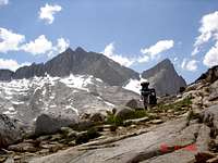
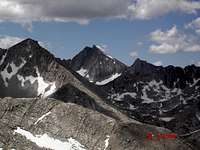
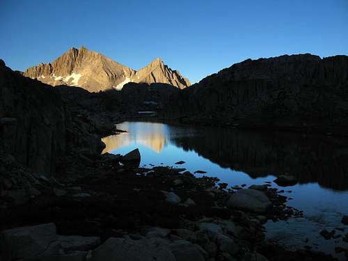
Seven Gables is the great peak in the Bear Lakes basin close to Lake Italy and Mount Hilgard. It rises above most of the surrounding peaks and therefore has outstanding views ranging from Mount Lyell to Mount Whitney. The area is quite remote, seldom visited, and offers a great feeling of solitude and perfection.
Seven Gables was first climbed in 1894 by Theodore Solomons and Leigh Bierce. Shortly after his ascent, Theodore Solomons wrote of the spectacular views on the summit... "I was too awed to shout. The ideas represented by such words as lovely, beautiful, wild or terrible, cold or desolate, fail to compass it. Words are puny things, and the language of description quite as impotent as the painter's brush. Roughly speaking, one might say that the sight was sublime and awful. I can scarcely conceive of another scene combining the peculiar qualities of that view in a higher degree, and I believe I was then looking upon the finest portion of the crest of the Sierra Nevada Mountains - their scenic culmination, their final triumph." (SCB 1, no. 6, May 1895: 230.)
In addition to the views, good climbing can be found on Seven Gables, and the peak has earned a postion on the Sierra Club's Sierra Peaks Section Mountaineer's List, a selection of 35 peaks put together based on the quality of their climbing. There is also the bonus of a fantastically positioned summit block... overhanging the edge and exposed on three sides, but only requiring a very easy class 3 move to ascend.

Getting There

Route Map
Approach from Vee Lake
Seven Gables is located in the heart of the Sierra Nevada in between Yosemite and Kings Canyon National Parks. As a result, there are several options for an approach, including a side trip from the popular John Muir Trail and trailheads on both the western and eastern side of the Sierra.
Note that the final 18 miles of the drive to Lake Edison and Florence Lake are on a bumpy, winding (but paved) road that is often only one lane wide as you approach the trailhead. Allow 45-60 minutes for this portion of the drive.
| Lake Edison (37.36735° N, 118.98340° W) From the Central Valley make your way towards Prather and continue east on Highway 168 towards Shaver Lake and then Huntington Lake, following the obvious road signs. At Huntington Lake, turn right onto well designated Kaiser Pass Road and follow it another 17 miles to an intersection where the road splits to Lake Edison. Turn left at the intersection and follow the road another 6 miles to Lake Edison. Alternatively, the Bear Creek Diversion Dam trailhead can be used, turn right onto the OHV road 3 miles from the turnoff to Lake Edison and follow it 2 miles to the diversion dam (four wheel drive is necessary). |
| Florence Lake (37.27671° N, 118.97660° W) Follow the directions mentioned above from Prather to Lake Edison. Instead of turning to Lake Edison at the intersection 17 miles from Huntington Lake, continue straight here for another 6 miles to Florence Lake. |
| Pine Creek Trailhead (37.36110° N, 118.69184° W) Turn west onto Pine Creek Road off Highway 395 approximately 10 miles northwest of Bishop (28 miles south of the Highway 203 intersection to Mammoth Lakes). Follow Pine Creek Road 10 miles west to the trailhead parking area. |
Approaches
| Route | Distance | Gain | Description |
|---|---|---|---|
| Lake Edison | 13.1 miles one-way | 6600 feet +1200 feet on return |
Lake Edison marks the standard starting point from the west, and the route can be shortened (only marginally) by beginning at the Bear Creek Diversion Dam (four wheel drive required). From the southwestern shore of the lake (near the dam) follow the Bear Ridge trail up and over Bear Ridge, meeting the John Muir Trail after 5 miles. The John Muir Trail descends through the forest to reach Bear Creek 6.8 miles from the trailhead. Most of the route follows Bear Creek, but note the crossing of the Hilgard Branch (8.7 miles in) and especially Bear Creek (9.9 miles in) can sometimes be challenging during the peak runoff of heavy snow years. After the trail crosses Bear Creek ascends one mile in the direction of Marie Lake and Selden Pass, but take the left fork at a junction to head east to Sandpiper Lake. From the southern shore of Sandpiper Lake you can climb the northwest slope/west ridge, or continue further to reach the south slope. |
| Florence Lake | 17.4 miles one-way | 7100 feet +1500 feet on return |
From the Florence Lake Trailhead wrap around the southwest side of Florence Lake and cross its inlet via a footbridge after 3.6 miles. After 8 miles pass the Muir Trail Ranch and soon turn left (north) at a junction towards Selden Pass and eventually onto the John Muir Trail. The trail begins a steep ascent before easing at Sallie Keyes Lakes. Continue north over Selden Pass and leave the trail at the southern side of Marie Lake to wrap around the east side of the lake. After passing the north end of the ridge to your right (east), contour cross-country northwest to Sandpiper Lake at the base of Seven Gables. |
| Florence Lake Ferry | 13.7 miles one-way | 6700 feet +1100 feet on return |
If the timing works for your party it is possible to take the ferry across Florence Lake, saving the effort of walking around the southwestern shoreline. The ferry operates several times each day in season (generally early June to late September. For the most current information, check the Florence Lake Ferry Service website. From the east shore of Florence Lake, follow the remaining route description above. |
| Italy Pass/Pine Creek | 14.7 miles one-way | 7400 feet +1900 feet on return |
Italy Pass is a very reasonable alternative for those on the east side of the Sierra, with a much easier drive but more cross-country travel. Follow the trail as it switchbacks to Pine Lakes, bearing right beyond the lakes to Honeymoon Lake and Granite Park. In Granite Park the trail eventually fades away about 800 feet below Italy Pass. Continue cross-county over the pass immediately south of Mount Julius Caesar. Once over the pass, traverse southeast to White Bear Lake (and a half dozen other lakes with bear inspired names) and make a gradual descent via Vee Lake to Seven Gables Lakes at the base of Seven Gables below its steep eastern face. |
Routes
There are good routes on Seven Gables from both the east and the west; the south slope is particularly enjoyable as you near the knife edged ridge just below the summit.
Seven Gables is capped by a spectacular summit block somewhat overhanging and very exposed on three sides. The block only requires only an easy class 3 move to mount, and isn't difficult at all. Looking down the east face and gaining the highpoint will certainly add a bit of excitement for some parties.
 |
Northwest Slope / West Ridge – Class 2-3 The northwest slope of Seven Gables is essentially a class 2 slog, a bit sandy as you bear left and more talus closer to the ridge on the right. Depart the trail at the eastern shore of Sandpiper Lake south of the stream coming down the large bowl northwest of the summit. There is a short section of thick brush, not very consequential when on the descent but tougher when on the ascent. Nearer the summit there are a few easy and unexposed class moves, no real routefinding involved. |
 |
South Slope – Class 3 From the east the south slope is reached by traversing from the saddle with Gemini, descending about 100 feet as you approach the southern aspect of the peak. From the west the slope is easily gained from the unnamed lakes east of Medley Lake. Climb one of the class 3 chutes through the short, gray cliff bands at the base of the slope to the class 2 scree and talus field above (there are several viable routes though the band). Climb 1000 feet further to a knife edge ridge overlooking the sheer east face. Follow the ridge left (west) on the unexposed south side until it is possible to cross over a second intersecting ridge and into a chute on the west side of the mountain. Descend this chute about 40 feet to a class 3 chimney that then ascends 100 feet to a wall just beneath the summit and against the dropoff to the east. During my trip I didn't descend quite far enough and instead climbed a class 4 face adjacent to the chimney (the choice available is between a somewhat exposed, solid, class 4 face and a less exposed, loose, class 3 chute). From the impass below the summit wrap clockwise around to the west and then to the north side of the summit, passing over (not under as Secor mentions) a very obvious overhanging block which is visible during most of the final portion of the climb. |
 |
North Ridge – Class 2-3 The north ridge begins at the saddle immedately north of Seven Gables, easily approached from the west. If approaching from the east the saddle is most easily reached on its north side. From the saddle, continue to the summit, with less technical terrain to the right and a few class 3 moves available closer to the ridge. |
 |
East Face – Class 4 This route ascends the north side of the east face and tops out 200 feet north of the summit. There are class 4 sections both at the beginning and end of the route, with mostly class 3 terrian between. If you have additional content to add please summit a route page or send the information to me and I can include it here. |
Red Tape
Seven Gables and Little Bear Lake
Wilderness Permits:
Seven Gables is in the John Muir Wilderness within the Sierra National Forest. No permits are required for day trips but overnight trips require one throughout the year. Quotas are in place year round, and if approaching from the west permits are most conveniently picked up at the High Sierra Visitor Information Station on Kaiser Pass Road (one mile before the split between Lake Edison and Florence Lake, open seasonally) or the High Sierra Ranger District office in Prather. Check the Sierra National Forest permit website for the most current information. If approaching from the east you will begin in Inyo National Forest and permits can be picked up at the White Mountain Ranger Station in Bishop or the Mammoth Ranger Station in Mammoth Lakes. Quotas here are in place from May 1 through November 1. Check the Inyo National Forest wilderness permit website for the most current information and reservation availability.
Food Storage:
No bear canisters are required, but proper food storage is a must.
Campfires:
Fires are prohibited above 10,000 feet.
| High Sierra Ranger District Office 29688 Auberry Rd Prather, CA 93651 (559) 855-5355 |
Inyo National Forest Wilderness Permit Office 351 Pacu Lane, Suite 200 Bishop, CA 93514 Wilderness Information Line: (760) 873-2485 Permit Reservation Line: (760) 873-2483 |
Current Conditions
Current NOAA / National Weather Service Forecast
When To Climb
Highway 168 is not plowed past Huntington Lake in winter, so a winter approach is most realistic from the east (but will still require multiday travel). In early season snow is present at higher elevations, but those familiar with snow conditions should not have any difficulties.
 |
 |
 |
 |
 |
 |
Camping
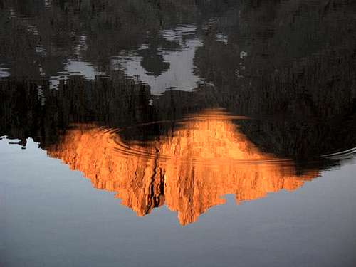
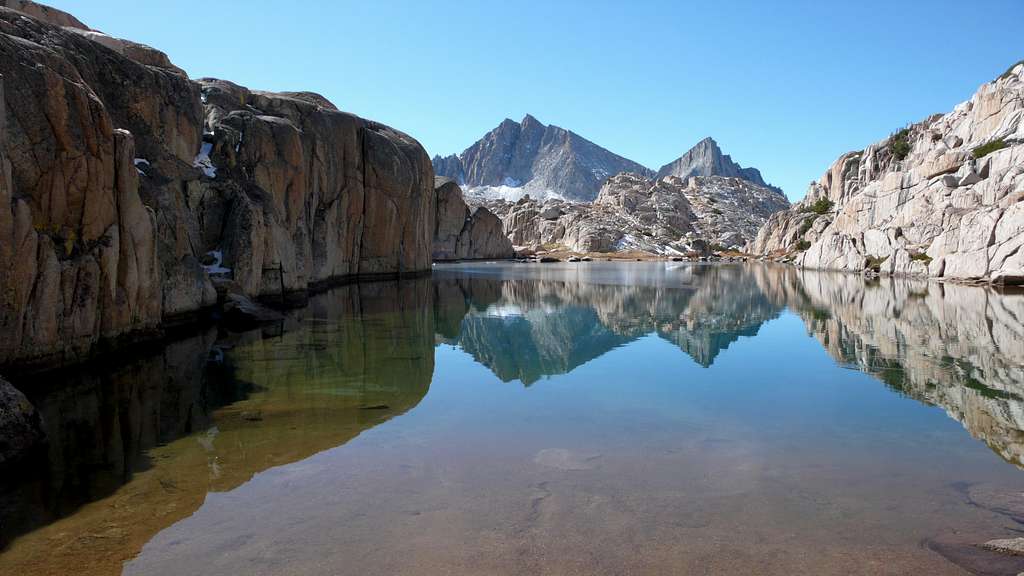
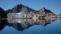
Seven Gables Reflected in Vee Lake
One of the highlights of a visit to Seven Gables is the outstanding backcountry camping options. Most approaches to Seven Gables have scenic creek and lakeside locations available throughout the trip. Closer to the peak lies Sandpiper Lake to the west and Seven Gables Lakes to the east. Marie Lake is very scenic and popular due to its proximity to the well traveled John Muir Trail.
There are also many options for staying in established campgrounds at both Florence Lake and nearby Lake Edison, as well as on the drive in from Kaiser Pass. Most campgrounds are first-come, first-serve, though a few can be reserved. Check the Sierra National Forest website for the most current information.
Dispersed camping is allowed throughout most of Sierra National Forest, and is a good alternative to staying in an established campground.
Etymology
"The peak was named September 20, 1894, by Theodore S. Solomons and Leigh Bierce. 'The south wall of the gap we found to be the side of a peak, the eccentric shape of which suggested in the name Seven Gables, which we hastened to fasten upon it.' (SCB 1, no. 6, May 1895: 230.) The lakes were first named on the 15-minute quad.” – Peter Browning, Place Names of the Sierra Nevada (2004)