
-
 20951 Hits
-
 83.49% Score
-
 18 Votes
|
|
Mountain/Rock |
|---|---|
|
|
37.76610°N / 107.8262°W |
|
|
13693 ft / 4174 m |
|
|
Overview
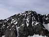
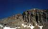
Seldom climbed and often overlooked, Rolling Mountain is another rugged, high 13,000 foot mountain in the Silverton west group. Farther south than more popular Ice Lakes Basin, not many make the climb of this worthwhile peak. Depending on the direction one is viewing the mountain, the name "Rolling" can seem quite just or undeserving. From the basins to the south, Rolling has a gentle appearance, and looks like a walk-up. While the north of Rolling is a dramatic face, composed of steep couloirs, and loose rocky cliffs. The actual climbing on Rolling is no harder than class 2+ - 3 scrambling on some loose rocks towards the top. A climb of Rolling Mountain provides great views of Ice Lakes Basin to the north, Lizard Head Wilderness to the northwest, and many other 13,000 foot peaks surrounding the Silverton area. This is a great trip for one who likes to avoid the crowds. It is odd to see many people climbing Rolling.
 |  |  |  |
Getting There
The best way to get to Rolling Mountain, is from Silverton, Colorado. Follow Highway 550 North towards Ouray for about 3 miles until you see the turnoff for the South Mineral Campground. Take this turn(left) and follow the good quality dirt road for another 3-4 miles until you arrive at the South Mineral Campground. From the campground, continue southwest on a 4x4 dirt road for another 2.5 miles to where the road ends near a large meadow. This is the Rico-Silverton Trail and the start of the appoach to Rolling Mountain.
Red Tape
No permits required now, but check with the San Juan National Forest (970-247-4874 or www.fs.fed.us/r2/sanjuan) for more information. There is limited parking at the trailhead.
When To Climb
Summer months are best. This area holds snow late into the year and sometimes year round. So be prepared.
Camping & Other Lodging
There are a number of good undeveloped camping sites in the meadow near the trailhead. Generally a good source of running water nearby.
Silverton also has a variety of hotels, motels, and inns that would all serve well as a starting place for your climb. Check out www.silvertoncolorado.com for more detailing information on availability and rates.
Maps
San Juan National Forest
Uncompahgre National Forest
External Links
- Local Weather Radar
The local weather radar image as provided by the National Weather Service.
Liba Kopeckova - Oct 1, 2013 9:47 pm - Voted 7/10
bicentennialColorado rank 150. (Bicentennial - among the highest 200 in Colorado). Driving directions: 4.3 miles to reach South Mineral Campground, 2 WD vehicle, nice dirt road; 7.1 miles to reach Rico-Silverton TH - rough road, crossing streams, 4WD high clearance vehicle.