
|
|
Mountain/Rock |
|---|---|
|
|
38.12310°N / 119.5275°W |
|
|
Toulumne |
|
|
11118 ft / 3389 m |
|
|
Overview
Wells Peak sits between the scenic meadows of Thompson Canyon and Stubblefield Canyon near the northern boundary of Yosemite National Park. It is surrounded by spectacular looking peaks such as Tower, Erhnbeck and Hawksbeak Peaks, which also make for great companion climbs during the same trip.
The peak is fairly easy to climb, with Class 2 routes leading to the summit and a short Class 3 section at the very top to add some challenge. The are also opportunities for some short Class 4 and Class 5 climbing on the north and west sides of the summit.
Wells Peak offers spectacular views of the surrounding peaks and canyons in northern Yosemite. Yet it is rarely climbed because of it's relative remote location.
Note that there is no summit register. Please consider providing one if you climb this peak...!
 |
 |
 |
 |
Getting There
There are several points of entry that you can use to get to Wells Peak. The 2 best options are listed below. The description of the Twin Lakes trailhead was mostly taken from bearbnz's Hawksbeak page. His page has some additional directions.
1) The Twin Lakes trailhead is the shortest (9 miles) and probably the best option to approach the peak. The best access to the area is from US 395. From the north, as you arrive in the tiny town of Bridgeport, watch for the first right hand turn just after the Mini Mo-Mart fuel station. This is Twin Lakes Road. From the south, enter Bridgeport and proceed to the end of town and take the last left-hand turn, right across from Buster's Market. This is the same Twin Lakes Road. At the end of the road is Mono Village. If you are staying overnight, enter the Village and bear left, along the shoreline to the boat trailer parking and a large dirt turnaround. The trailhead parking is along the edge of the turnaround. Dayhiker parking is along the shoreline of the lake prior to the turnaround.
From either parking area (they are quite close together), head into the campground through the main entrance. There are 3 roads branching off to the west from here. Take the middle road, and watch for a meadow on your left after a couple hundred yards . If you see it, you are on the correct road. Otherwise, backtrack and try again, there are many roads running through the campground area. When you see the meadow, continue on and you will pass a cable stretched across the road, and this is the recognized trailhead. Follow the road to the sign indicating the turnoff to Barney Lake. Continue west past Peeler Lake. When you reach Kerrick Meadow, head straight west to the obvious low point in the ridge that separates Kerrick Meadow from Thompson Canyon. There is a low-use trail that crosses over the ridge which is described in Ben Schifrin's guidebook, though it is not maintained and difficult to locate.From the top of the ridge, you'll see Wells Peak directly to the west on the other side of Thompson Canyon.
2) Leavitt Meadows Pack Station is located on CA Hwy 108, just west of I-395. Free parking is available in the trailhead parking area near the campground, north of the pack station. You can hike the 16 miles to Wells Peak, or have Leavitt Meadows Pack Station take you in on horse back most of the way. Rates for horses are available on their web site. Call well in advance to reserve horse and guide if you decide to pack in with them.
Follow the Walker River trail south past Upper Piute Meadow and then take the trail to Rainbow Canyon past Hawksbeak Peak.
 |
Red Tape
Free wilderness permits are required for overnight stays in both the Hoover Wilderness Area and Yosemite National Park.
Call the Summit ranger station at (209) 965-3434 near Pinecrest ahead of time and they will prepare a permit for you in advance, or the Bridgeport Ranger Station at 760-932-7070 if traveling from the east.
Food Storage
Bear cannisters are required by federal law in most areas of Yosemite National Park. Keep in mind that Wells Peak is near the boundary of the Hoover Wilderness Area. Bear cannisters are not currently required in the Hoover Wilderness Area.
When To Climb
The climbing season varys each year depending on how much snow the area receives during the winter months. Hwy 108 closes during the winter, making winter access more difficult from the west. So typically the most popular time to climb the mountain is from June through October.
Camping
There are several established camp sites near the trail in the northern end of Thompson Canyon that are good.
If the mosquitos are bad, consider camping here. There is some nice flat ground by a tarn on the NW side of Center Mountain that is open and breezy. However, there is no tree shelter there.
Mountain Conditions
Call either of the ranger stations listed above for current conditions.
![]()

The following links provide additional information on local conditions.
Hwy 108 road conditions.
Etymology
Colonel Rush Spencer Wells (1874-1951)
Rush Spencer Wells was born December 8, 1874, Ft Bayard, New Mexico Territory, the son of Brigadier General (Ret.) Almond B. Wells and Mary Eliza Spencer Wells of Geneva, New York.
Colonel Wells entered the U.S. Army as a 1st Lietenant in Troop C, 3rd U.S. Volunteer Cavalry in South Dakota in 1898 and retired as a Colonel on December 12, 1928. During the early years of his career, he served in the 7th, 8th, 9th, and 14th cavalry regiments.
He was awarded two citations during his service as an aide to General Leonard Wood in Cuba. He was cited for coolness under attack in the Moro uprising in the Philippines and received the Silver Star for gallantry in the Villa uprising in Mexico.
During World War I he served in the 350th infantry, 88th division and afterwards was appointed Demobilization Officer of the Northwest in Des Moines, Iowa. He served as professor of Military Science at the University of Alabama for four years and Co-Area Professor of Military Science in the Boston Aera which included Harvard, Princeton, Yale and other area universities. Immediately prior to retiring in 1928, Colonel Wells served as Chief of Staff to the Commanding Officer of the Organized Reserves of Connecticut.
Following his retirement, Colonel Wells and his wife Eleanor Thomas Wells lived in Robinson Springs, Montgomery, and Auburn Alabama with their eight children: Rush Spencer Jr; Walton Thomas; Eugene Beverly; Martha Eleanor; William Peyton; Helen Elizabeth; Hamilton Peyton; and Charles Melvin.
Colonel Wells died December 14, 1951 in Montgomery, Alabama. He is buried in Oak Hill Cemetary, Autauga County, Prattville, Alabama.
- History and photo provided with appreciation by the family of Colonel Wells.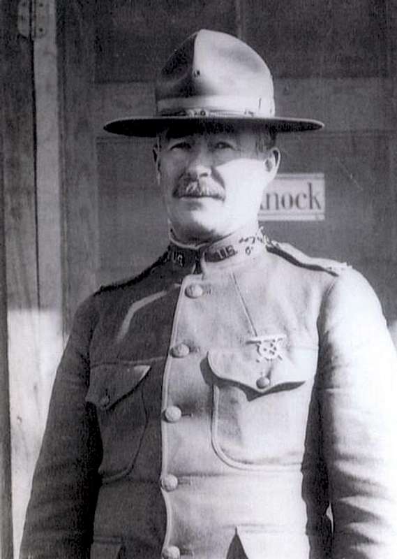
"Named by R. B. Marshall, USGS, for Rush Spencer Wells, an army officer. (Farquhar: Marshall.) The name appeared on the third Dardanelles 30' map, 1912."
- Peter Browning, Place Names of the Sierra Nevada
External Links
- Leavitt Meadows Pack Station
Web site provides directions to the trailhead at Leavitt Meadows Pack Station and rates for pack (horse) trips. - Yosemite National Park website
Website contains a wealth of information about the park, rules and regulations, etc.