
|
|
Mountain/Rock |
|---|---|
|
|
0.1667°S / 78.5667°W |
|
|
Hiking, Scrambling |
|
|
Spring, Summer, Fall, Winter |
|
|
15728 ft / 4794 m |
|
|
Overview
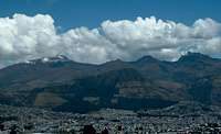
The Three Peaks
The "Pichinchas" consist of the three summits Guagua, Rucu and Padre Encantado, and is located 10 Km west the capital city of Quito. These peaks were first climbed in 1582 and still today both Guagua and Rucu are very popular acclimatization climbs for those seeking to climb the higher peaks of Ecuador. The easy access and non-technical nature of the peaks also make for great treks for non-climbers wanting to experience high altitude.

Rucu
Guagua (4794m/15,728ft) is the higher and younger of the peaks. It is a highly active volcano that most recently had a major eruption in 1999. The eruption caused 2mm of ash to be deposited on Quito 10km away. Since then vulcanologist have placed data collecting units all over the mountian. Despite the activity of the volcano, it is still considered very safe to climb.

Padre as seen from Rucu
Rucu (4698m/15,413ft) is the older and slightly lower summit to the Northwest of Guagua. Since the Teleferico opened Rucu's popularity as a trek was tempered by the potential for crime along the beginning of the standard route which goes through a less fortunate neighborhood of Quito.
Padre Encantado (4685m/15,370) is less popular and little information exist for climbing or trekking it.
Getting There
There is both public and private transport to these peaks. Public transport is both complicated and time consuming. Private transport is easier although more expensive.
Guagua
It is best reached using private transport from New Quito. There are many agencies in the area and a vehicle and driver rental for the day is about $100US for up to 4 climbers. This will make the drive shorter and you can customize your day. If you insist on using public transport to the tiny village of Lloa Located at 3030m. This leaves you with a long hike up the road while eating the dust of every tractor and car that passes. Private transport takes you through Lloa to a parking place at 4150m where it is best to start to allow for more acclimatization. If you'd like most 4WD can make the drive on to the Ecuadorian Civil Defense hut at 4550m when the conditions are dry.
Rucu
The following directions are included but are not currently recommended by any of the local guides or agencies due the the high rate of crime in the neighborhood you must pass through.
The regular starting point for Rucu is from Cruz Loma. A combination of public and private transport can be used but isn't always reliable. Take a bus from "old Quito" to San Roque market and then hire a pick-up truck for the rest of the drive to Cruz Loma (approx. 10$ US).; From the antenna, follow the obvious grassy trail on the northwest side to the base of the mountain (1h1/2)
Schitthaedt adds the following as an alternate approach for Rucu: An alternative approach to Rucu Pichincha from Quito is to climb the ridge to the north of the valley seen from the city (the southern ridge being the normal "Cruz Loma" approach). This approach begins in the neighborhood known as El Bosque, from a shopping center called Dicentro. From Dicentro you follow the roads leading up to the broadcast towers, then follow the ridge toward Rucu, passing the cliffs known as Condor Rumi on the way. Head for the left side of the summit pyramid, where the trail meets up with the standard Cruz Loma trail. This nothern approach is a little harder, but it is more interesting and probably a bit safer because it begins in an upper-class neighborhood. There are many buses that go to El Bosque. The one that I took started at the shopping mall Quicentro and headed northwest. It of course had a sign saying "El Bosque" in the window.

Looking up the mountain from the Teleferico station.
Rucu via the Teleferico
The safest option to climb Rucu is to take a cab to the Teleferico, a sky tram up the hillside which is visible from most of Quito. Users can ride the Teleferico to around 3800 m. Ecuador residents with proof of residency get the "Discounted Rate" of $4.90. Foreigners only have the option of the Express Line rate of $8.50. (Thanks to SP member mtngeek for this updated information.)
You may need to give the security at the ticket counter your passport number to be allowed to hike from the top of the Teleferico.
Up and back should take between 3 and 6 hours. The Teleferico opens after 9 am.
Guides, Red Tape & Misc
No permits or red tape, although you may encounter armed army patrols that guard the government antennas at the trail head.
Also as stated before, it is NOT recommended to climb Rucu from Cruz Loma.
Most of the guide services located in "New" Quito offer everything from fully guided tours to transport only. Shop around to get a feel for each operator and also to check current prices. It shouldn't cost more than $140US per day for a jeep and driver for up to 4 climbers. Most are located around Veintimilla and Amazonas streets.
When To Climb
These peaks can be climbed year around but are best climbed during the dry seasons which typically are June through August and December through February. Nights and mornings are generally clearer and present the best views.
Camping
Camping isn't needed for these peaks due to the fact that they are typically done in one day from Quito. There is a governement run hut at 4550m on Quagua above Lloa. It does not have much more than a roof, 4 walls and a toilet. You must bring your own stove, sleeping pads and sleeping bags. It usually cost a few bucks and some food paid to the caretaker.
However if you must camp then keep in mind the following. Camping is permitted everywhere on the mountains of Ecuador BUT, it is not safe to camp at the base of Rucu of these. The proximity of the city makes this trailhead vulnerable to robbery.
Mountain Conditions
Generally the peaks are snow free but on occassion a storm will cover the peak with a brilliant white layer. Rain and mist are almost certain. Be careful when climbing in wet and misty conditions. The rock can become very slick and the visibilty poor. Take care to remember the way down or be with someone who knows the way.
External Links
- Guagua Pichincha
Great video of climb from 2005
Thank you
Thanks to the previous editors of this page: MIZTFLIP and Vertx and BergClmbr7 for their contributions.
dielotr - Jan 13, 2013 10:45 pm - Voted 10/10
TeleferiqoMinor corrections: -Change "Teleferico" to "Teleferiqo" -Teleferiqo drops passengers off at about 4000m, according to a sign near the trailhead. -Teleferiqo runs until 730pm
jm141302 - Oct 8, 2013 11:30 am - Hasn't voted
Incorrect PhotoThe photo of Padre Encantado on the overview page isn't correct. This is a peak called Cundur Huachana, which is also accessible via the normal route to Rucu.
Vivyenne - Nov 9, 2013 4:05 pm - Hasn't voted
Cruz loma?My undestanding is that Cruz Loma is the viewpoint at the top of the Teleferiqo. As an alternative to the Teleferiqo, there is a pretty easy-to-find route which starts in the "Parque Miraflores", just north of the San Juan tunnels.. there is a path into the park which climbs directly for about 20 mins, hang a left in a big field with some buildings on the northwest side until you hit the road, from there the path heads pretty straight and rather steep up to Cruz Loma, with frequent altitude signboards from the city of Quito posted along the way. Took us about 3 hrs starting in Miraflores to get to the top of the Teleferiqo.
gbreynolds86 - Jun 16, 2015 6:58 pm - Hasn't voted
Re: rucuHello - Thank you for your helpful post. I was hoping to tap into your expertise... I am one of four guys headed to Quito in July. We wanted to make this a more adventurous trip, so the middle portion will be at an ecolodge and we hoped to conclude the trip with a hike up a local mountain/volcano. My concern is that we are not experienced climbers (hardest climb = Adirondaks and it was easy), although we are athletic (2 of us training for a marathon and the others could be). This is why I thought Rucu, starting from the top of Teleferico, would be an appropriate choice. Now the questions... 1) Do you think Rucu is an appropriate choice for our fitness level, experience and desire for something challenging but feasible? 2) Altitude sickness is another concern of mine. Our plan is to spend 2 days in Quito, then 2 days at an Ecolodge at a lower elevation, then back to Quito for 3 days. If we do the hike on the 3rd day once we return to Quito, do you think that altitude sickness will be a real threat? 3) I'm worried about the lack of information on getting to the top. Your description was perhaps the best so far. Just wondering if you think it really is self-evident or if there is more directional information we will need. I really appreciate your help!! Best, Greg
Sergio - Mar 7, 2015 7:05 pm - Hasn't voted
Teleferico versus teleferiqoDear Dielotr and all other colleagues. The correct name is Teleférico according to the Real Academia de la Lengua Española: teleférico. (Del fr. telephérique). 1. m. Sistema de transporte en que los vehículos van suspendidos de un cable de tracción. Se emplea principalmente para salvar grandes diferencias de altitud.
Miguel1 - Aug 15, 2015 2:57 pm - Hasn't voted
TelefériQoThe generic name in Spanish for an aerial cable car/cable-suspended tram is teleférico, but the name with a capital Q substituted for the c is the brand name for this specific one in Quito (Qo for Quito). And for those with neighborhood safety concerns, taxi cabs are exceptionally reasonable in cost to skip the tougher areas. Flagging a cab in Quito is fast and easy. $3 or less gets you most places.
weshelor - Nov 27, 2015 4:40 pm - Hasn't voted
RucuCan climb any day of the year, unless raining or storming heavily. Teleferico ticket office opens approx. 8:15 a.m. fri, sat & sun, 9:00 a.m. mon-thur. The best time to be there and climb is at opening. Storms and lightning occur often around 1-3 p.m. People do quick-climb Rucu with one night's acclimatization, but any delay around the summit could put one in major danger. 3 to 5 nites in Quito before climbing is advisable. The easy route is pretty straightforward, hiking on the ridge for around 1 hour 10-20 minutes, then the only trail goes around and to the right(north) of the ridge for 30 minutes, finally up all the loose sand. Since the trail has migrated 80 meters to the right(west) because of the thousands of people coming down, it is important to remember that an 80 meter left(East) trail traverse is needed as one approaches the summit or you will end up on the rock west of the summit. Ignore all pointed signs and markers, as they are markers for long-distance trails. Another option after hiking 1 hour 20 minutes to rocky ridge, is to scramble straight up the rock ridge to the summit, Staying directly on the ridge for first half hour until an open area is reached, then staying left and below the ridge for 20 minutes until the "Carlos Iberra" marker is reached. Can go down and around to right, then cross parallel on the ruta de baca to the actual paso,or left around and over to the the Paso De La Muerte. Directly down to the paso from the left is the most fun, jugs and easy lo-angle climbing just when you need it, easy crawl across the paso and one exposed step to the right and up through the notch. Most climbers don't rope up. 20 more easy minutes to the summit. Run/walk down the easy normal trail to the north for fun and to avoid afternoon storms. Total time 4-5 hours. I've summited over 100 times paso de la muerte.
19Peter43 - Jun 25, 2017 3:17 pm - Voted 9/10
Benighted? Soldiers helpI climbed Pichincha more or less monthly in early 70's while teaching 2 years in Quito. Never benighted. Some 40 years later the TF ascent helped but after assisting a rookie scrambler for several hours, we were benighted at the upper station. Soldiers helped by calling a farmer who brought us back into town in a small truck (through the "difficult" neighborhood below) for a modest fee. Yes, I was older and slower.
MattieQuigley - Mar 15, 2018 11:16 pm - Hasn't voted
Rucu Without The Teleferico, Climbing Area and LadrillosHey! I've been living in Quito for the last two years and have never had any issues with robberies or crime doing Rucu without the Teleferico. It's a very common thing for trail runners to do. Also this posts misses the 4th Pichincha peak: Ladrillos Finally it would be cool to mention the climbing area that has just opened up close to the top of the teleferico. For more information go to: https://hikeecuador.wordpress.com/2018/02/15/los-pichinchas/
Csimmi - Aug 9, 2018 12:39 pm - Hasn't voted
Teleferiqo Opening HourTeleferiqo opens at 8 am - might be important, since the earlier you start the trek, the more likely you will have a clear weather and great views!