
|
|
Mountain/Rock |
|---|---|
|
|
39.59360°N / 120.64°W |
|
|
Hiking, Sport Climbing, Bouldering, Scrambling, Skiing |
|
|
8591 ft / 2619 m |
|
|
Overview
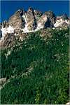
Sierra Buttes is the dominant peak in the Lakes Basin area of northern Sierra Nevada. There is nothing higher north until Lassen Peak and south until Mount Lola. It is a craggy peak of volcanic origin, with lots of spectacular pinnacles on top. The summit pinnacle is about 100 feet high and slightly overhanging, on top of which is a fire lookout hut perched precariously, with exhilarating exposure. However, with the aid of the steel staircases anyone can reach the top with no problem.
Sierra Buttes has an easy hiking trail to reach the summit, yet its craggy cliffs offer technical rock climbing challenges. It also contains steep ski runs on several of its flanks.
The northeast flank of Sierra Buttes has a few deep glacial canyons containing lakes. Many more glacial lakes are in the immediate north, forming Lakes Basin, an isolated area of glaciated landform in the northern Sierra. The Lakes Basin area is popular for back-country skiing in winter, fishing and hiking in summer. Nearby Plumas Eureka State Park was the site of the earliest downhill ski resort in California.
Sierra Buttes is also a short detour from the Pacific Crest Trail. Although a 4WD trail reaches the base of its summit pinnacle, it is no longer open to the public (4WD travelers must hike the last mile and half). The amount of visitation to Sierra Buttes is moderate due to the remoteness of Sierra County, with a population of just around 3000.
 |
 |
 |
 |
 |
Getting There
The main trailhead for day hikers is Packer Lake. Take highway 49 eastbound from Sierra City, take the left turn off for Gold Lake road, then turn left follow signs to Packer Lake. Before reaching the lake follow signs to Sierra Buttes trailhead on a left turn-off. This is at about 6200 feet elevation, 3 miles from the summit.
If you drive the unpaved road beyond the signed Sierra Buttes trailhead, you will reach Packer Saddle, a ridge-top trailhead on Pacific Crest Trail. From here Sierra Buttes is about 2 miles southward.
From the opposite direction on Pacific Crest Trail the trailhead is on Highway 49 right in Sierra City. This is only about 4500 feet elevation so the climb is more strenuous.
The Sardine Lake trailhead offers access to cross-country scrambling routes in summer and steep ski runs in winter. To go there take Gold Lake Road then turn left following signs to Sardine Lake.
 |
 |
Red Tape
None.
When To Climb
Summer or winter. Gold Lake Road is closed in winter, but it is easy to reach the Sardine Lake or Packer Lake in winter on skis or snowshoes, due to the short distances.
Camping
Sierra Buttes is not in a wilderness area, so a permit is not required for camping in the back country. There are many fee camp grounds near the lakes off Gold Lake Road. Nearby towns of Sierra City (closest), Graeagle, and Portola have commercial lodging available.
External Links
- Sierra City - the California Mountain Experience
Tourist information including camping, lodging, photo gallery. Sierra Buttes photo on top of page. - Virtualguidebooks.com
Virtual reality panorama taken from the fire lookout. Quicktime installation required. - Kevin's Hiking Page
- A winter outing - March 12, 2004