
-
 69819 Hits
-
 93.82% Score
-
 45 Votes
|
|
Mountain/Rock |
|---|---|
|
|
34.22290°N / 117.5854°W |
|
|
Hiking |
|
|
8859 ft / 2700 m |
|
|
Overview
Cucamonga Peak is located in San Bernardino County in Southern California in the Cucamonga Wilderness area of the San Gabriel Mountain Range.
The mountain is accessible all year, although the hiking season is typically between May/June – Oct/November. It can be busy during the summer months and of course on weekends, although you do need to be in decent physical shape to hike to the top.
The easiest route is 12 miles round trip with 3900 ft of elevation gain. Most hiking guides rate it as a strenuous or difficult hike. It starts at the parking area at the head of Icehouse canyon (4960 ft) and ascends over 3.5 miles to Icehouse saddle (7580 ft), along the Icehouse canyon trail heading east-southeast. The saddle can be very cold and windy, even when warmer down below, so bring appropriate clothing for windy conditions. From the saddle there are multiple trails branching off to other peaks. Take the Cucamonga Peak Trail going in a southerly direction. It contours around Bighorn Peak, staying pretty much at the same elevation until you reach Cucamonga Saddle. At this point you will begin a set of switchbacks. They will continue until about 8600 ft at which point you will find a marked trail that takes you to the peak along a steep north facing gully, which can sometimes retain snow into May.
Take clothing for various temperatures depending on what time of year you go. Trail shoes are fine if you are just going up for a day hike, and there is no snow or ice.
 |
 |
 |
 |
Getting There
Cucamonga Peak is about 8 miles north of Upland, and about 43 miles from Los Angeles.
Driving east on the 210 Freeway, exit Baseline Road in Claremont. Turn left on Baseline. In one block turn right unto Padua Avenue. In 1.7 miles at the stop light, turn right onto Mt. Baldy Road. in 7.2 miles you pass the Mt. Baldy Visitor Center in Mt. Baldy Village. You can get a Forest Adventure Pass and wilderness permit here. Continue 1.5 miles to the Icehouse Canyon entrance. Turn right and park in the large parking area. The trailhead begins at the opposite end of the parking lot entrance.
Driving west on the 210 Freeway, exit Mountain Ave. in Upland. Turn right and go north on Mountain Ave. In 5 miles, you will come to Mt. Baldy Road. Turn right and continue 5 miles to the Mt. Baldy Visitor Center where you can purchase an Adventure Pass and secure a wilderness permit. Continue to the Icehouse Canyon parking lot/trailhead as described above.
Tire chains may be required in winter based on conditions.
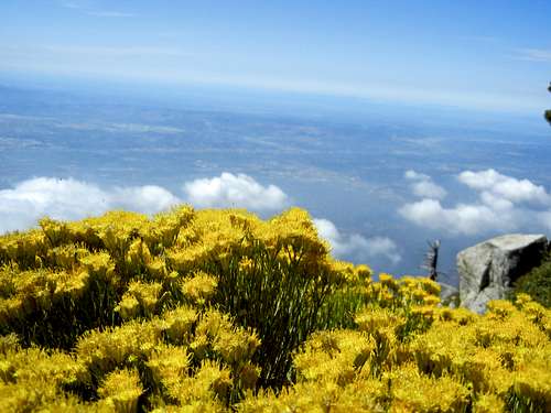
View south from summit 9.1.13


Cucamonga Wilderness
Red Tape
National Forest Adventure Pass is required for each vehicle that is parked at any trailhead. Fees are $5.00 a day or $30.00 for an annual pass. These can be obtained from any of the ranger stations or from many of the local merchants. One can be purchased at the Mt. Baldy Visitor's Center.A wilderness area visitor's permit must be obtained for day hiking and overnight camping before you enter the Cucamonga Wilderness on the Middle Fork of Lytle Creek and Cucamonga Peak Trails.
If hiking on the Cucamonga Peak Trail, pick up a wilderness permit at the Mt. Baldy's Visitor's Center. You can request a permit by phone a day or so prior to your entrance. The phone number is 909.982-2828. The Visitor Center generally opens at 7 am, so if you plan to begin your hike before then, ask that your permit be posted on the outdoor message board for pickup.
If approaching Cucamonga Peak on the MIddle Fork Trail, obtain your permit at the Lytle Creek Ranger Station. The phone number is 909.382-2851.
Party sizes are limited 12 people.
Open campfires are prohibited.
If you attempt this hike during winter, go properly equipped. If there is hard snow or ice on any part of the trail do not attempt without crampons.
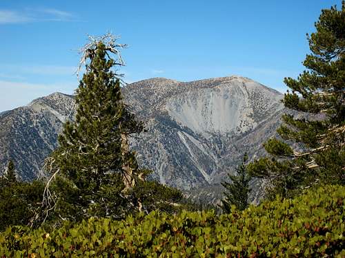
![Mt. Baldy (10,064 ) from summit of Cucamonga Pk]() Mt. Baldy from summit of Cucamonga Peak
Mt. Baldy from summit of Cucamonga Peak
Party sizes are limited 12 people.
Open campfires are prohibited.
When To Climb
Trail guides recommend June to October as the best times, but if you want fewer people try the spring or fall. Weekdays are always better as well.If you attempt this hike during winter, go properly equipped. If there is hard snow or ice on any part of the trail do not attempt without crampons.
 Mt. Baldy from summit of Cucamonga Peak
Camping
There are several sites in the area and they require permits. Trail camps: Kelly Camp is located at elevation 7840 ft off the trail to Ontario Peak. Cedar Glen is lower down at 6400 ft on the Chapman trail in Icehouse Canyon.Always check for weather and road conditions.
tarol - Oct 11, 2007 9:44 am - Voted 9/10
San Bernardino Nat'l Forest phone number has changedMight want to include the contact info for both the Supervisor's Office and the Lytle Creek Ranger Station.