A Triple Peak Traverse of the Tallest Mountain in Utah's Wasatch Mountain Range.
Trever is a trail runner, the kind of guy who can run 50 miles in the mountains, and show up for work the next day just as energetic as if he’d spent the previous day watching TV. We work together, so he knows that I love climbing mountains. In fact, last January (2008) he and I had joined a group of amateurs to climb Mt. Nebo’s South Peak, but regrettably that climb was stopped short of the peak. I suppose because I had climbed both the North and the South Peaks on two separate previous trips, I didn’t have a much of a desire to finish the unfinished business of the January climb, and I didn’t really hear much about it from Trever either. However, about nine months later he started talking about climbing Mt. Nebo again, although, come to find out, he had actually been on trail runs on the mountain two other times between January and October and one of those times he summited the south peak. Nonetheless, he still had an urge to climb it again, but this time he wanted to traverse all three of its peaks. This idea of doing all three peaks in one trip rejuvenated my lost interest, and so I told him I was up for the traverse any Saturday in October, but some how we didn’t end up going until the day after Halloween.
October 31, 2008 I was at a Halloween dance in Payson Utah, and it was raining outside. I couldn’t help but to wonder if our plans for the next days climb were going to be ruined. Alas, I was on the phone with Trever at 7:30 am the next morning, and asking him if he was ready to tackle the new snow on Mt. Nebo, and he said he was. Pleased, I told him I’d meet him in half an hour.
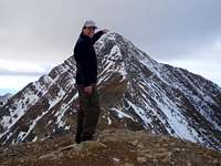
Standing on the false summit en route to the North Summit.
Our plan was to traverse the peaks from North to South; meaning we would summit the highest of Mt. Nebo’s three peaks first. So we drove up Payson Canyon, past Payson Lakes and to the Mona Pole road (aka Monument Trailhead) at approximately 8500 ft, where the North Route trail begins. By 9am we were hiking. Keeping a steady pace we soon reached the 10,640 ft saddle from which point we skirted North Peak Mountain to arrive at Wolf Pass where the north peak of Mt Nebo becomes clearly visible. From Wolf Pass to the false summit the climb becomes very steep and this steep section was blanked in four or five inches of snow. However, to our surprise none of the snow appeared fresh, causing us to believe that even at elevations over 10,000 ft only rain had fallen during the night. We had the mountain to ourselves; nevertheless it was quite curious that there were dog tracks ascending, from a few days earlier which often seem to be unaccompanied by any human tracks.
Within in two hours of leaving the car we reach the exposed false summit. The chill of the wind caused us to recall layers we had earlier removed and to don gloves and ski hats before we be started out over the knife-edged ridge which connects the false summit to Mt Nebo’s highest peak. The wind had blown this ridge virtually clean of snow, and it took us about 45 minutes to negotiate it and be delivered on the first of the three peaks we planned to summit that day. Arriving close to noon on Mt. Nebo’s 11,928 ft north peak, naturally we paused not only for pictures and to sign the log book, but also for lunch.
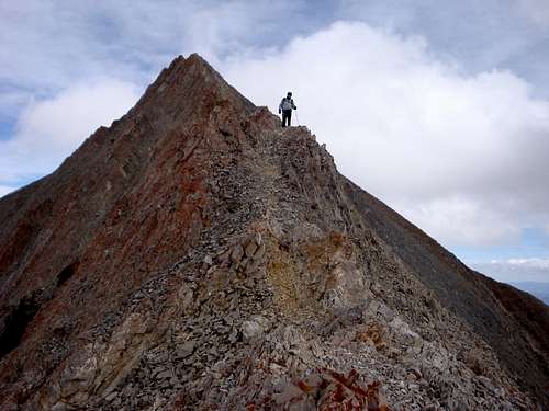
Descending the sharp narrow south ridge of Mt Nebo's north peak.
With food in our belly’s we were soon descending the south side of the north peak en route to the 11,824 ft middle peak. We elected to climb down the east aspect sticking as close as possible to the ridge. There were a couple of spots where the ridge was so narrow and sharp that we actually straddled it. I had read that this section is class 4, but it felt more like a class 3 to me. Once we reached the low point on the ridge between the north and middle peaks, we switched from the east aspect to the west aspect and began the ascent. As soon as we encountered snow, we also encountered the familiar dog tracks this time with the occasional accompaniment of melted, but recognizable, human tracks. It took us only about a half an hour to cover the approximate half mile distance (as the crow files) from the north peak to the middle peak. We paused on the middle peak only for pictures and were heading south again by 12:40 pm, en route to our third peak of the day, the south peak.
On the 11,824 ft middle peak of Mt Nebo, with the 11,928 ft north peak behind.
Our route from the middle peak to the south peak took us along the west-side of the ridge, where we soon came across a cairn above a very steep (I’d guess 45 degree) scree covered slope that we realized we’d have to slide down in order to skirt a cliffed-out section of the ridge. The south peak less than half a mile away (as the crow files) was clearly visible, so before we began the slide down the scree we attempted to pick out the route we would ascend once we left the scree-covered slope. I went first, using one trekking pole for balance as I skied down the slope on my feet. Reaching about half way down I paused off to the side to allow Trever to come down, and while I waited I noticed tracks in some snow below giving us a landmark at which we would leave the scree-covered slope. As Trever descended I shot some video of him but before he reached me, I continued down to the tracks in the snow, certain they would be familiar. Reaching the tracks, which ended up being unrecognizable, it seemed to me that we must have lost over 300 vertical feet as I looked back up at the cliff of a ridge line between the middle and south peaks that we were now below. It was 300 feet we were now going to have to regain en route to the south peak, but it was the safest route making the loss of elevation a smart choice.
Regaining the ridge between the middle and south peaks.
Although maybe only six inches deep at best, at this point we had patchy snow to climb up giving as some decent footing. Once we regained the base of the cliff, about 20 feet or so below the ridge-line, we got into some drifted snow which we could see would provide us a path to the top of the ridge and safely past the cliff area. We reasoned that once on top of the ridge we would have a trouble-free route to the south summit. So up and onward we went occasionally post-holing in the drifted snow, and before we knew it we on top of our third peak of the day. Oh, and yes, there were the familiar dog tracks, here and there en route to, and on top of, the third peak. From the time we left the car, to the time we arrived on the south peak five hours had past; 1.5 hours of which were spent negotiating from the middle peak to the south peak.
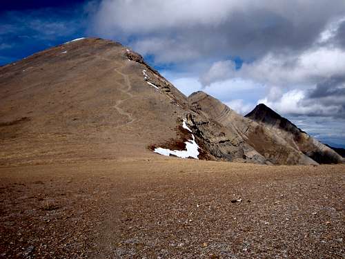
Sticking out of the snow on the south peak we found a coil ring notebook wrapped in a couple of plastic bags acting as the summit log. We went ahead and signed it and took some pictures, as we discussed our descent options. As we saw it we had three alternatives, one we could go back the way we had come, two we could continue south and then east down the Andrew’s Ridge trail all the way to the Mount Nebo Scenic Byway and then try our luck at hitching a ride back to our car, or three we could continue south going down the Andrew’s Ridge trail to the point where the Nebo Bench trail dissects it, and then follow the Bench trail north along the bench of the east aspect of the mountain and back to the car. We knew the third option covered the most distance but unlike the first option it would allow us to cross different terrain and take in different sites, and contrasting the second option it would lead us to our car. Without any disputes we decided on the third option leaving the 11, 877 ft south peak shortly after 2pm.
We jogged down the south peak and on to the ridge that leads south, looking back once to snap a photograph of all three peaks we had crossed that day.
We jogged down the south peak and on to the ridge that leads south, looking back once to snap a photograph of all three peaks we had crossed that day. When we got close to the saddle of the ridge where the trail turns east and does some switchbacks downward, we cut off a little bit by route finding straight down to one of the visible switchbacks. Reaching the switchback we were out of the wind so we opted to take a break and eat some food before continuing down to the bench trail.
The intersection of the bench trail and the Andrew’s ridge trail isn’t marked, and so we weren’t absolutely sure we’d reached it when we did, and as such we lost a few minutes scouting around to verify before leaving the eastward bound trail and heading off north. The bench trail isn’t a flat trail, nor is it a straight trail, in fact it turned out to be eleven plus miles of ups and downs and winding all around. On the positive side, however, it reveals numerous breath-taking views and crosses various scenic streams, but it seems especially long after one has climbed roughly 4,000 vertical feet, seven miles and three mountain peaks. I’m certain that Trever, the trail runner, could have jogged all the way back, but I wasn’t up for that. However, we did following a very steady and sometimes rapid pace, and yet it took us four and a half hours to return to the car from the time we left the south peak. All in all we were on the mountain for nine and a half hours, and covered close to 18 miles. About half-way down I used up the last of the three liters of water I had packed for the day, making the jug of water I had stashed in the car a very welcome reward for a successful triple peak traverse of the tallest mountain in Utah's Wasatch Mountain Range.
Parents refers to a larger category under which an object falls. For example, theAconcagua mountain page has the 'Aconcagua Group' and the 'Seven Summits' asparents and is a parent itself to many routes, photos, and Trip Reports.


Comments
Post a Comment