
-
 16572 Hits
-
 81.18% Score
-
 13 Votes
|
|
Mountain/Rock |
|---|---|
|
|
46.52870°N / 11.84190°E |
|
|
Hiking, Trad Climbing, Scrambling, Via Ferrata |
|
|
Summer, Fall |
|
|
9550 ft / 2911 m |
|
|
Overview
 Boèseekofel / Piz da Lec da Boè
In the eastern part of the Sella Group in the Dolomites, the interesting but somewhat unknown area of the Valbon Mountains is offering a wide range of climbing and mountaineering possibilities. One of the most important summits of this area is Boèseekofel. The mountain offers completely different aspects from different directions: a very wild, rarely visited, steep and high north-west face, a lower, more enjoyable south face and a mostly harmless east flank. The latter is home to a ferrata, famous among the Sella ferrate because of its two long and exposed ladders. Neighbouring peaks in this part of the Sella Group are Neuner / Sass dals Nü / Sasso delle Nove (2904m) and Zehner / Sass dals Diesc / Sasso delle Dieci (2916m). Together with Sass de Mesdi (2980m)they form the sundial of the village of Kolfuschg / Colfosco.
On the east face of Boèseekofel there are two routes - the normal hiking route as well as the aforementioned ferrata. Both can be easily reached from either the Valbon chair lift or from Franz Kostner Hut. Except for the exposed ladder part both routes are mostly harmless.
The south face can be reached from the Valbon chair lift or Franz Kostner Hut as well. There are no easy routes; however the climbing routes you find there are of excellent quality. Only drawback is the fact that the face remains wet until late in the year so that the routes are generally climbed in summer or autumn only.
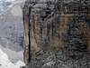
The north-west face hovers above the coffin like Val di Mesdi, which connects Kolfuschg / Colfosco with the Sella plateau. It is roughly 600m high and due to the long approach and sometimes lacking route quality is is far less popular than the south- or east faces. Routes are long difficult and almost unprotected by bolts or pitons. Also, route finding can turn into a major problem. On the upside you are climbing in Val di Mesdi, one of the most beautiful sceneries in the whole Dolomites.
Routes
 Via Ferrata Route
There are about 18 different routes on Boèseekofel, the following list describes some of them. None of the routes are bolted as is usual in the Dolomites. Even the stances are not bolted. Bring a full rack. On some of the routes the use of hammer and pitons might be advisable.
- East Face
- Regular Route: an easy hike-up on a well marked path, 2-3 hours from the Crep de Munt cable car station
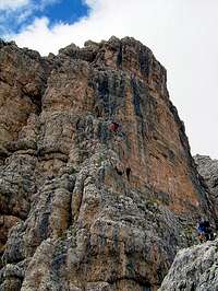
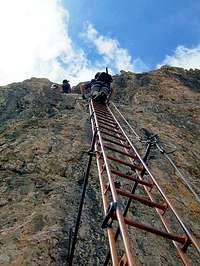
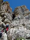
- Via Ferrata: one steep and exposed part, mostly easy, 1-2 hours from the Valbon chair lift, very dangerous in case of thunderstorms!
![Two long ladders near the end...]()
![It is probably the most...]()
![Descent on normal route]()
- South Face
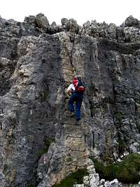
- "Weg durch das Saxophon": 8-, 6 hours, 5 pitches, very risky, very demanding, a big thing, R. Mittersteiner and Stefan Sader 1987
- "Via Giorgio Viale": 6 and A2, 8 hours, most parts an aide route, hard and rarely done, L. Boi and E. Menardi 1980
- "Castiglioni/Detassis": 4+, 2-3 hours, a wonderful climb, mostly through chimneys, often wet but excellent rock, often done, first ascent by E. Castiglioni and B. Detassis in 1935.
- "Mayr/Vonmetz": 6+ and V+ (or V+ and A2), 6 hours, good rock but rarely done, very exposed, J. Mayr with W.Steinhauser and L. Vonmetz in 1971
- "Dorigatti/Giambisi": 5+, 3-4 hours, an other very good climb with superb pitches on very good rock, A. Dorigatti and A. Giambisi in 1973
![By buddy Charly is leading...]()
![The Dorigatti/Gambisi route...]()
![My wife Rike at the beginning...]()
- North Face / North-West Face
- "Dibona": 4-, 3-5 hours, rock quaity excellent in the upper part, rotten down below, very beautiful.
- "Via dell'Orecchio": 5+ and A2, 6 hours, mostly cracks, first ascent by C. Zanantoni with partners in 1985
- "Zanantoni/Avanzolini": 5, 6 hours, good route along logical lines, first ascent by C. Zanantoni and partners in 1971


|


Getting There
 Boèseekofel / Piz da Lec da Boè east face
The trailhead for the east and south faces is Corvara. From Corvara take the cable-car to Crep de Munt. The regular hike-up route is a marked trail which starts west directly behind the cable car station at Crep de Munt. For the Via Ferrata and the south face climbs take the second stage, the Valbon chair-lift. From the top of this chair lift you can reach the bases of the climbs on well-marked and obvious trails.
The approach to the north-west face follows Val di Mesdi from Kolfuschg / Colfosco a little higher up on the Grödner Joch Road.
- From North (Brenner Pass)
- Take the Brenner Motorway A22 southward to Waldbruck / Ponte Gardena
- Leave the motorway and take SS242 into Grödnertal / Val Gardena
- After Wolkenstein / Selva Gardena the road ascends to Grödner Joch / Passo Gardena and Sellajoch / Passo Sella.
- Take the Grödner Joch road to Kolfuschg / Colfosco and Corvarra
- From Belluno:
- Drive along SP1 as far as Ponte nelle Alpi
- Turn onto SS51 to Castello Lavazzo
- There switch to SS51b to Vodo di Cadore
- In Pierosa switch to SS48 to Andraz
- Continue along the SS244 to Corvara
- For Kolfuschg / Colfosco switch to SS243 to Grödner Joch / Passo Gardena
- From Venice and Treviso:
- Take motorway A27 to Belluno, exit Pian di Vedoia,
- Turn onto the SS51 to Pierosa
- Switch to SS48 to Andraz
- Here switch to SS244 to Corvara
- For Kolfuschg / Colfosco take SS243 to Grödner Joch / Passo Gardena
- From Innichen / San Candido and Dobbiaco / Toblach:
- Drive along SS49 as far as San Lorenzo di Sebato
- Continue along SS244 to get to Corvara.
- For Kolfuschg / Colfosco take SS243 to Grödner Joch / Passo Gardena
- From Brunico:
- Drive along SS242 to get to Corvara
- For Kolfuschg / Colfosco take SS243 to Grödner Joch / Passo Gardena
Red Tape
 Boèseekofel / Piz da Lec da Boè west face
No red tape. Fee for the cable car and chair-lift. This obviously can be avoided if you hike up (but no one will do that, it's a long way to the top ...).
Accommodation
Mountain Conditions
Maps & Books
Books:There is one very recommendable book, Sella - Langkofel Extrem, which the original submitter kletterwebbi used to help put up this page. It gives an overview over hundreds of climbing routes in the area. Two thirds of the book deal with the Sella Group.
- Climbing
- Sella - Langkofel Extrem
Richard Goedecke
Alpenvereinsführer
Rother Verlag
ISBN: 3-7633-1315-X
- Val di Fassa - Guida alle arrampicate sportive
Renato Bernard/Gabriele Bonnano
Dora' Publisher, Bolzano
- Sella e Sassolungo
Luca Visentini
Ed. Athesia, Bolzano/Bozen. (both in Italian and German languages)
- Classic Dolomite Climbs: 102 High Quality Rock-Climbs Between the Uiaa Grades III and VII (also available on CD)
Anette Kohler, Norbert Memmel
Mountaineers Books
ISBN: 0 8988 6693 6
- Sella - Langkofel Extrem
- Vie Ferrate
- Klettersteige Dolomiten
H. Höfler, P. Werner
Rother Verlag
ISBN: 3 7633 3096 8
- Hülslers Klettersteigführer
E.E.Hülsler
Bruckmann Verlag
ISBN: 3 7654 4161 9
- Cicerone Via Ferratas of the Italian Dolomites: North, Central and East
John Smith, Graham Fletcher
Cicerone Press
ISBN: 978-1852843625
- Klettersteige Dolomiten
- Hiking and Trecking
- Höhenwege in den Dolomiten
H. Dumler
Bruckmann Verlag
ISBN: 3 7654 3860 X
- Dolomiten
P. Fleischmann
Kompass Verlag
ISBN: 3 8705 1409 4
- Dolomiten 3
F. Hauleitner
Rother Verlag
ISBN: 3-7633-4060-2
- Dolomiten 4
F. Hauleitner
Rother Verlag
ISBN: 3-7633-4061-0
Maps:
I have been using the maps by Kompass Verlag. There are two which differ in scale:- Val di Fassa, Marmolada, Gruppo di Sella
Kompass Map WK 686
ISBN: 3 8549 1768 6
Scale: 1:25000
- Sellagruppe / Gruppo di Sella
Kompass Map WK 59
ISBN: 3 8549 1066 5
Scale: 1:50000
- Val Gardena & Alpe di Siusi
Tabacco Map 05
- Höhenwege in den Dolomiten
In Memory of Stefan "kletterwebbi" Weber
 A note from the SP staff
Stefan Weber, the member we all used to know from his climbing pseudonym kletterwebbi, died on May 28th 2004 in southern France at the age of 37.
Stefan joined SP early on in 2002 and contributed a number of excellent pages and routes to this site. He was an accomplished climber excelling in difficult alpine and technical routes. The Dolomites, especially the area around Gröden / Val Gardena were special to him, as it was his old ancestral home.
kletterwebbi was always willing to share his knowledge and experience with other climbers, mainly here on SP, but also on other sites. He contributed his IT expertise as webmaster of his local section of the German Alpine Club, where he also engaged in leading trips for fellow members. Besides his climbing and mountaineering activities he was a musician, a composer of contemporary music. Stefan will be greatly missed by us all.
This page will be kept in honor of kletterwebbi, one of SP's most talented, knowledgeable members, and without a doubt, one of our greatest fellow mountaineers.
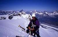
The picture was taken on the summit ridge of Lyskamm.
Lukas Kunze - Jun 27, 2005 2:53 pm - Hasn't voted
Untitled CommentIt is very beautiful to stay at the Kostner hut for a night (beautiful views to Marmorlada)...
But make sure there is a room available (lots of traffic at this hut) !!!
Homepage of the hut www.rifugiokostner.it/indexuk.htm