
|
|
Mountain/Rock |
|---|---|
|
|
41.02861°N / 122.79526°W |
|
|
7596 ft / 2315 m |
|
|
Overview
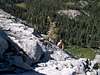
Ycatapom Peak is located near the eastern edge of the Trinity Alps Wilderness of northern California. Closest town is Trinity Center, CA. The peak's northern face rises abruptly from the bottom of Poison Canyon. This 1200-foot wall hosts the longest technical rock climbs in the Trinity Alps. The rock is granite and - despite its "broken" appearance - is surprisingly solid. Most routes on the north face range from easy to moderate in difficulty. Protection is generally adequate but long runouts are not uncommon. The cracks are often shallow and flared. The area has been developed as a pure traditional climbing area and thus you will encounter no bolts. Non-technical scrambling routes (descent options) exist on the mountains west ridge and south face.The mountain's curious name comes from the Wintu word which translates to "leaning mountain". 1985 saw the establishment of mountain's first technical route, The Old Goat (class 4), by K. Kehoe. S. Mackay and B. Nyberg established the classic Orion (III, 5.7) in late 80's.
Information paraphrased from S. Mackay's Rock Climbing Northwest California.
 |  |  |  |  |
Getting There
The closest town is Trinity Center, California located on CA highway 3. From points north, take I5 to Ireka and then take CA 3 south to Trinity Center (route subject to winter closing). From points north, take I5 to Redding, CA and follow CA 299 from Redding to its intersection with CA 3 in Weaverville. Take CA 3 30 miles north to Trinity Center.From CA 3 in Trinity Center, turn west onto Swift Creek Road (well signed junction). Follow it for approximately 1.4 miles to a signed junction and turn right toward Lake Eleanor and Poison Canyon Trailheads (ignore the distance and FS road number in Mackay's book - they're not accuarte). In about 1 mile, turn right again onto FS road 37N55. Follow 37N55 passing a fork (probably within the first mile) - keep right here. Keep right again at the next fork finally reaching a 3-way junction where you need to make a sharp left to stay on 37N55 (there should be a gate - possibly closed - on the minor road that goes straight). You'll reach the inconspicuous trailhead (no large parking lot - just a widened pull out) - but it is marked with a sign - shortly after crossing North Fork Swift Creek. Park your car on the right side of the road (more parking space available a few hundred yards down the road) and look for the marked trailhead sign on the left side.
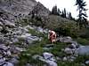
Follow the steep Poison Canyon Trail for about 2 miles (according to Mackay's book - in reality it's probably a bit more than that) to a signed junction with the Thumb Rock Trail. Nice views of the peak can be had within about 0.75 mile from the road. Stay left at the junction on Lilypad Lake Trail. Hike for approximately 0.3 miles further, passing through a small meadow. Look for a climbers' camp on the far side of the meadow (fire pits visible from trail on right side). At this point, you should see a boulder fan to your left eminating from the base of the peak's northwest face. Turn left off trail and follow the boulder fan. The boulders become scree and the climbing steepens. Look for an obvious dihedral near the west edge of the north face of Ycatapom. Most technical routes start on a class 3 ledge just to the left of this dihedral (Orion starts almost in the dihedral).
 |  |  |  |  |
Red Tape
No permits are required for climbing or other day use activities. Overnight stays require a permit which can be obtained (free of charge) from the Shasta-Trinity National Forest ranger station in Trinity Center, CA. See Mountain Conditions section below.When To Climb
Typical season for Trinity Alps climbing is June through October. Given the fact that the technical routes on Ycatapom peak are located on its northern face, they tend to stay wet later into the season. Note that the Forest Service locks the access gates to the area (on unpaved roads) from October 30 to May 1 regardless of weather conditions.Camping
Backcountry climbers' camp located at the foot of the boulder field (see description under Getting There Section) is the most convenient for those headed for the technical routes on the peak's north face. Additionally, numerous FS-operated pull-in campgrounds exist along CA highway 3. These include Preacher Meadow (1.5 miles SW of Trinity Center on CA 3), Alpine View (6.6 miles SW on CA 3 then 2.5 miles S on county road 160), and Trinity River (9.5 miles N of Trinity Center on CA 3). Private campgrounds exist in Trinity Center.Mountain Conditions
Primary Contact:Shasta-Trinity National Forest
Coffee Creek Ranger Station
Star Route 2, Box 4630
Trinity Center, CA 96091
530-266-3211
Alternative Contact:
Shasta-Trinity National Forest
Weaverville Ranger District
PO BOX 1190
Weaverville, CA 96093
530-623-2121
Guide Books
Steven Mackay's Rock Climbing Northwest California (Falcon Publishing - out of print) is the only publication that lists technical climbing routes on Ycatapom Peak. The text description of the routes seems to be good enough only to find the starting point - once on the route you're largely on your own in terms of route finding. There is an overview shot of the mountain with all the listed routes superimposed but it is not detailed enough to serve as a route topo.Dennis Lewon's Hiking California's Trinity Alps Wilderness provides a description of the Poison Canyon Trail hike.
Both books are highly inaccurate in their description of how to reach the trailhead. You're better off following directions on this page.
Misc. Route Information
BruceNybergmentions the following regarding Orion:Actually Steve and I did the first ascent in the late 90's. Forget the pins and take several small nuts. When we did the route many of the small cracks were full of dirt. Since then the cracks have become cleaner. A good route on good rock. Cheers, Bruce
External Links
- Trinity Alps Aerial Photos
A few photos of Trinity Alps peaks taken from a low flying plane in winter conditions. Includes a nice shot of Ycatapom Peak under snow.
rpc - Jan 4, 2006 12:07 pm - Hasn't voted
Untitled CommentThank you very much for the info. Bruce. I'll add it to the main page.
Now I know there's someone here on SP I can bother for route beta in the area :)
Regards,
Radek
Diggler - Sep 26, 2003 3:20 pm - Hasn't voted
Untitled CommentFrom '1500 California Place Names,' etymology of "Ycatapom" states that the Wintu word wayk'odipom means "north step place (whatever that means!)." Nice page.
jtschanz - Jun 15, 2004 5:15 pm - Hasn't voted
Untitled CommentJust want to add something here. You will see on most maps a nice-looking route that cuts over from I-5 near Castlella to Hwy 3 just north of Coffee Creek. If you are coming from the north, you will be tempted to take this road rather than getting on Hwy 3 all the way up in Yreka. DO NOT give in to this temptation! What looks like a good road on the map is in reality a 2.5 hour trip on winding, rough, unmarked gravel and dirt roads. If you are really want to drive this road, do it on the way back!
brucenyberg - Jan 1, 2006 9:48 pm - Hasn't voted
Untitled CommentActually Steve and I did the first ascent in the late 90's. Forget the pins and take several small nuts. When we did the route many of the small cracks were full of dirt. Since then the cracks have become cleaner. A good route on good rock. Cheers, Bruce
rpc - Jan 4, 2006 12:07 pm - Hasn't voted
Untitled CommentThank you very much for the info. Bruce. I'll add it to the main page.
Now I know there's someone here on SP I can bother for route beta in the area :)
Regards,
Radek