
-
 76734 Hits
-
 91.14% Score
-
 34 Votes
|
|
Mountain/Rock |
|---|---|
|
|
41.00100°N / 123.047°W |
|
|
9002 ft / 2744 m |
|
|
Overview
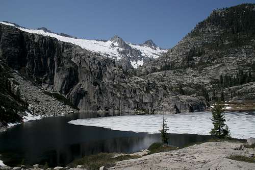
Thompson Peak above Upper Canyon Creek Lake
Thompson Peak is the highest Peak in the Trinity Alps Wilderness, a vast assemblage of craggy granite mountains in northwestern California (Trinity Alps Wilderness is the second largest designated wilderness area in California). Thompson Peak is the second highest mountain in Northern California west of the Cascades, after 9027 feet Mount Eddy. Per SP member Ed Cooper "It is incorrect to say that there is no longer glacial activity in the area. The Thompson Glacier lies below the North Face of Thompson Peak. Late in the season, when most of the winter snow has melted, the crevasses and ice of this glacier are exposed. There is another smaller body of snow/ice to the right of the Thompson Glacier, below the north face that might also be considered a small glacier. Further, there is definitely one small glacier on a nearby peak that has crevasses and clearly displays glacier ice. The Trinity Alps have the distinction of being the only mountain range in the United States that lies entirely below timberline (small trees grow just below the final summit block of Thompson Peak) that contains active glaciers."
Thompson Peak has steep north and east faces and a gentle southwest slope. Permanent snow fields fill its wide north cirque and also below its east face. It is usually climbed from Canyon Creek Trail, ascending the class 2-3 South Ridge from the east. This route has a 8000 feet elevation gain. About 10 miles.
Canyon Creek Trail is one of the most popular backpacking routes in Trinity Alps Wilderness. It traverses a dramatic glaciated granite canyon and passes numerous subalpine lakes.
 |
 |
 |
 |
 |
Getting There
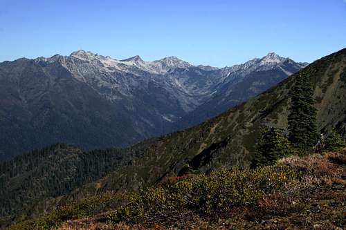
Thompson Peak, left of center and the rest of the high peaks of the Trinities loom high above Canyon Creek
Option 1: China Gulch Trailhead is acccessed from Hwy 3. Hwy 3 connects Yreka and Interstate 5 to Weaverville and Hwy 299. Hwy 3 is a long drive through the mountains. From Yreka and I-5 head south on Hwy for about an hour and pass through Fort Jones and Etna. Just on the outskirts of the little town of Calahan turn right or west on the road that goes to Cecilville. About 30 miles later, just as you are entering Cecilville turn left or south on a paved road to China Gulch. In about 3.5 miles the paved road turns to gravel and is marked as road 37N07. Follow this road another 5.9 miles to the China Gulch Trailhead. There is parking here for several cars.
Option2: The Canyon Creek trailhead is at the end of Canyon Creek Road, off Highway 299 in Junction City. Junction City is 8 miles west of Weaverville, the seat of Trinity County and location of National Forest Ranger Station. To get to Junction City, take Highway 299 for 53 miles west of Interstate-5 highway (Redding), or 95 miles east of Eureka on Highway 101. At Junction City turn north on Canyon Creek Rd. Proceed 13.5 miles to Canyon Creek Trailhead, elevation 3,000 feet.
Take Canyon Creek trail northward for about 15 miles to the end, then scramble to the top of the ridge on the left. Follow the ridge northward to Thompson. Total route length about 17 miles one-way.
Red Tape
Because most people will do this hike as a backpacking trip, wilderness permits are required. For permit information, see Camping section.
When to Climb
Summer is the best season. The upper mountain area is snow-bound in winter, although all access roads should be open in winter. Winter climbing may require ice axes and crampons, and snowshoes or skis may be needed to access the area.
Camping
Backcountry camping in Trinity Alps Wilderness requires a permit. A Camp fire permit is also required during fire season. To obtain permits, go to one of the National Forest ranger stations below:
Weaverville: P.O.Box 1190, Weaverville 96093; phone 530-623-2121.
Redding: 2400 Washington Ave, Redding 96001; phone 530-244-2978.
Campgrounds can be found along Canyon Creek Road, as well as in many places along Highway 299.
External Links
- Tony Cruz's 1998 climb to Thompson Peak
- Trinity Alps Weather
Local weather in the Trinity Alps area - USDA Forest Service
This is the main USDA Forest Service Website - good times
- A small collection of aerial photos taken from a low-flying plane including Thompson Peak in winter conditions.
Samantha - Aug 5, 2005 7:12 pm - Voted 10/10
Untitled CommentIs this doable in a long day?
rhyang - Aug 5, 2005 7:47 pm - Voted 10/10
Untitled CommentMatthew and I did it last Sunday. Whether or not it's enjoyable in a long day is another (subjective) matter :)
We didn't see a soul after the upper lake. There looked to be some nifty places to camp as well. Base-camping up there and then scrambling the nearby peaks over a few days could be a lot of fun. Sawtooth or Caesar Cap might be interesting - Matthew said Wayne Moss' book on the Trinity Alps had some beta on Sawtooth, but I don't have that one (yet).
rhyang - Aug 1, 2005 6:42 pm - Voted 10/10
Untitled CommentJust a thought - It's 8 miles to the upper lake. Then about 2 or 3 miles of cross-country travel (boulder-hopping and scrambling included). Maybe 20-odd miles round-trip, with ~6000' elevation gain. The real fun starts above the upper lake, since it's about 3000' of gain from there.
Samantha - Aug 5, 2005 7:12 pm - Voted 10/10
Untitled CommentIs this doable in a long day?
rhyang - Aug 5, 2005 7:47 pm - Voted 10/10
Untitled CommentMatthew and I did it last Sunday. Whether or not it's enjoyable in a long day is another (subjective) matter :)
We didn't see a soul after the upper lake. There looked to be some nifty places to camp as well. Base-camping up there and then scrambling the nearby peaks over a few days could be a lot of fun. Sawtooth or Caesar Cap might be interesting - Matthew said Wayne Moss' book on the Trinity Alps had some beta on Sawtooth, but I don't have that one (yet).
AriehDavid - May 2, 2011 11:47 am - Hasn't voted
Hobo GulchThe Hobo gulch "long way" is not mentioned on this page. While long, it is an incredibly beautiful hike through big trees, alpine forests, meadows, Trinity Alps history, and then to the high alpine. It can also be combined with a trip up to Papoose, or up to Thurston Peaks for an amazing multi-day wilderness experience.
Bob Burd - Sep 7, 2016 11:53 am - Hasn't voted
Elevation Gain"This route has a 8000 feet elevation gain. About 10 miles." This should read 6000 feet, not 8000 feet
pezzotto - Oct 4, 2018 8:55 pm - Hasn't voted
Correct the distanceThe distance from Canyon Creek trailhead to Canyon Creek Lakes (the section on trail) is about 7 miles. To the top of Thompson Peak is another 2 miles of scrambling