
|
|
Mountain/Rock |
|---|---|
|
|
37.35676°N / 118.78169°W |
|
|
Fresno, Inyo |
|
|
13220 ft / 4029 m |
|
|
Overview
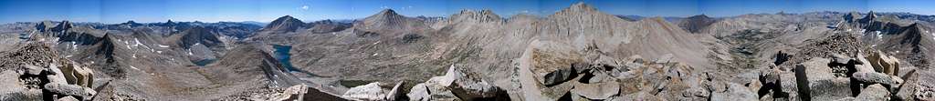
Mount Julius Caesar is located in the John Muir Wilderness of Inyo National Forest. The peak is hidden behind Mount Tom but situated 21 miles due west from Bishop, just two miles south of better known Mount Abbot and one mile southwest of more popular Bear Creek Spire. The summit is somewhat remote… requiring at least a seven mile approach with 5000 feet of round trip elevation gain from any direction. Visitors are rewarded with splendid views of high altitude alpine lakes and exposed granite basins, however, as Mount Julius Caesar sits perfectly between picturesque Granite Park to the southeast and the completely mesmerizing surroundings of Lake Italy to the west.The easiest and most heavily exploited route up Mount Julius Caesar is the class 2 ascent from Italy Pass immediately to the southwest. There are several other route options available, though most are increasingly more viable if visiting Mount Julius Caesar along with other nearby peaks in the area such as Mount Gabb, Mount Hilgard, or Bear Creek Spire. Fantastic views are available ranging from Mount Tom to the east, Granite Park and Royce Lakes Basin to the south, Seven Gables to the southwest, and Mount Hilgard, Mount Gabb, Mount Abbot, and Bear Creek Spire wrapping around the perimeter of Lake Italy from the west to the northeast.

Getting There
The route to Granite Park
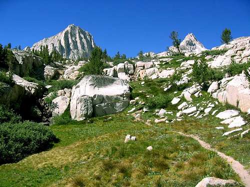
Mount Julius Caesar is almost always approached from the Pine Creek Trailhead west of Bishop. There is a good trail followed by an easy class 2 cross country route through Granite Park to Italy Pass on the south side of the mountain.
Mosquito Flat Trailhead is an excellent and underappreciated alternative to Pine Creek. The trailhead involves less mileage and is 2800 feet higher saving some elevation gain, but note this advantage is partially offset by the pass at Cox Col just north of Bear Creek Spire being nearly 700 feet higher. From Cox Col it is also necessary to drop 900 feet before navigating to the north side of Mount Julius Caesar further affecting this approach’s advantages. This route is more challenging (steep class 2-3) especially with a backpack and makes more sense if also climbing the nearby peaks north of Lake Italy. Still, the route offers great scenery and more interesting climbing than the ascent from Italy Pass and is worth considering if it is within your capabilities or desires.
Pine Creek Trailhead (37.36110° N, 118.69184° W)
Turn west onto Pine Creek Road (signed for Rovana) off Highway 395 approximately 10 miles northwest of Bishop (28 miles south of the Highway 203 intersection to Mammoth Lakes). Follow Pine Creek Road 10 miles west to the trailhead parking area.
Mosquito Flat Trailhead (37.43516° N, 118.74710° W)
Turn south from Highway 395 onto Rock Creek Road at Toms Place, approximately 15 miles south of the Highway 203 intersection to Mammoth Lakes (23 miles northwest of Bishop). Follow Rock Creek Road 10 miles southwest to the trailhead parking area at the end of the road.
Approaches
As noted above, Mount Julius Caesar is usually approached using the Pine Creek Trailhead followed by an ascent of the class 2 Southwest Slope or South Ridge from Italy Pass. The route from Mosquito Flat is somewhat more challenging, particularly if hauling a heavy pack, but leads to more interesting climbing (and is a bit quicker). Mosquito Flat is worth considering especially if other peaks to the west or north of Mount Julius Caesar are among your objectives. Both approaches are splendidly scenic.| Route | Distance | Gain | Description |
|---|---|---|---|
| Pine Creek to Italy Pass | 9.6 miles one-way | 6,000 feet +200 feet on return | From Pine Creek trailhead pass through the corral to the west and hike up the trail as it climbs towards Pine Lake and Honeymoon Lake. Just above Honeymoon Lake (6 miles from trailhead) there is a good camping spot and launching point for the second day summit attempt if not continuing on to Granite Park for the day. Continue on to Italy Pass through Granite Park. The trail is well marked for the first mile or two past Honeymoon Lake, but you quickly reach Granite Park and the trail all but disappears among the boulders. Continue heading west and Mount Julius Caesar and Italy Pass will soon come into view. Ascend easy class two slopes to the pass and the base of the South Ridge. |
| Mosquito Flat to Northeast Ridge or Northwest Face | 7.0 miles one-way | 4,100 feet +1,100 feet on return | Begin at Mosquito Flat trailhead and follow the well-maintained trail as it climbs slowly (very slowly) into Little Lakes Valley passing numerous lakes along the way. Just before the final 200-300 feet to Morgan Pass (3.3 miles from the trailhead) a side trail turns right (south) towards Gem Lakes. The trail is only maintained for the few hundred yards it takes to reach the last of the Gem Lakes. Continue up a use trail to the left of the inlet stream as it ascends through talus to reach Lake 11320 (the first of several small lakes encountered before Dade Lake). Follow the easiest visible route to Dade Lake and pass the lake on the eastern shore. There are several nice camping options at the north shore of the lake. From the inlet of Dade Lake climb talus and slabs (or snow) up the bowl to the south towards prominent Bear Creek Spire. Cross over Cox Col. Depending on conditions this is normally most easily done at the first notch to the south of the lowest notch left of the rib ascending to the crest. Early in the season ice ax and crampons may be necessary. The west side of the pass is trivial. Descend sand initially and then talus until you are able to traverse south on benches at 12,200 feet (this is all class 2). Continue south to unnamed Lake 12000 in the cirque between Mount Julius Caesar and Bear Creek Spire and climb the Northeast Ridge or Northwest Face. |
Route Overview
 | South Ridge/Southwest Slope – Class 2 This is the most commonly used route to the summit of Mount Julius Caesar as it utilizes the most straightforward approach and is the least technical option. Follow the approach directions above to Italy Pass. From Italy Pass simply ascend 800 feet up the south ridge of Mount Julius Caesar. Near the top either stick to the ridge or traverse left across the southwest slope to the true summit at the top of the west ridge. |
 | West Ridge – Class 2 Although Secor’s book describes the west ridge as a “classic class 3 climb” it is actually nothing of the sort. Well… it is classic… but rather a classic class 2 talus hop right up the ridge all the way to the summit. To reach the route from Italy Pass traverse northwest on easy terrain for about one third of a mile to the saddle at the base of the west ridge. Climb 850 feet from the saddle over large talus boulders (still class 2) straight to the summit. |
 | Northwest Face – Class 3 The northwest face can be climbed from a base at Toe Lake or after a ridiculously loose traverse over scree from the cirque in between Bear Creek Spire and Mount Julius Caesar. If already at Lake Italy it may be just as easy to head towards the southeast face via Jumble Lake. For the determined head to the base of the Northwest Face and climb the scree fan (no fun) to the prominent, light colored, and fairly obvious chute that ascends directly to the summit (as shown in the photo to the left). There is a large rib to the right of this route. The rock is very loose and tedious, but not too problematic if careful once you are above the scree fan. Near the top the chute opens up and you can pick your own options seeking the most stable terrain en route either directly to the summit or the ridge nearby on either side. |
 | Northeast Ridge – Class 3 The Northeast Ridge is the most direct route to the summit of Mount Julius Caesar if approaching from Mosquito Flat or climbing with Bear Creek Spire (the Northwest Face being the closest alternative). Follow the approach directions in the section above to the unnamed lake northeast of Mount Julius Caesar. From this cirque climb an obvious and loose class 2 chute to the top of the ridge (ice ax may be necessary in spring). Once at the crest follow the class 3 ridge to the summit generally keeping to the right as difficulties arise. |
Red Tape
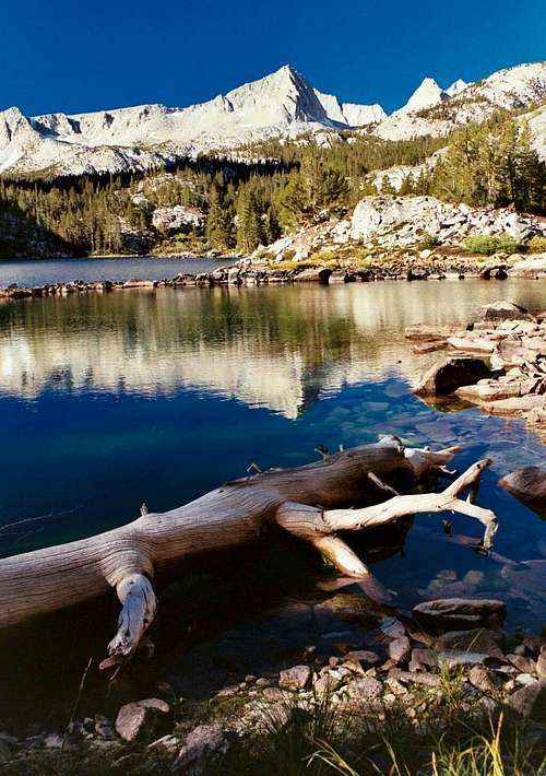
Mount Julius Caesar behind Pine Lake
Wilderness Permits:
From either Pine Creek/Italy Pass or Mosquito Flat the route to Mount Julius Caesar begins on Inyo National Forest land (the peak itself is on the boundary of Inyo and Sierra National Forests). No permits are required for day trips but overnight trips require one throughout the year. Permits can be picked up at the White Mountain Ranger Station in Bishop or the Mammoth Ranger Station in Mammoth Lakes. Quotas are in place May 1 through November 1. Check the Inyo National Forest wilderness permit website for the most current information and reservation availability.
Food Storage:
Bear canisters are not required for either the Piute Pass or Pine Creek Pass trails, but proper food storage is important.
Campfires:
Fires are prohibited above 10,000 feet and in the Pine Creek drainage.
Inyo National Forest Wilderness Permit Office
351 Pacu Lane, Suite 200
Bishop, CA 93514
Wilderness Information Line: (760) 873-2485
Permit Reservation Line: (760) 873-2483
Current Conditions
Current NOAA / National Weather Service ForecastWhen To Climb
Spring through fall is the normal season for visits to the summit of Mount Julius Caesar. Pine Creek trailhead is lower elevation (7400 feet) and far more accessible than any of the alternatives in the offseason and would be the best choice if targeting a winter ascent. Contact the Inyo National Forest office in Bishop as needed for winter road conditions. In some years snow may be present at higher elevations well into spring.  |  |  |  | |  |
Camping
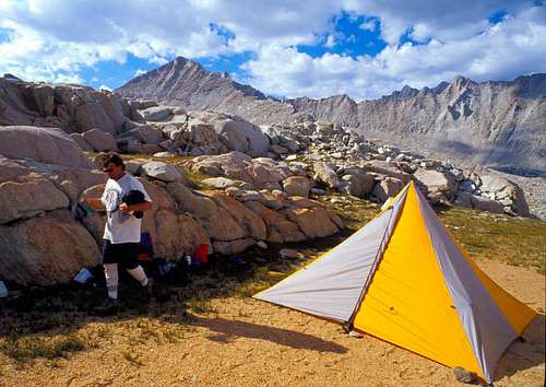
Camp with Mount Julius Caesar in the Background
Granite Park is an excellent backcountry destination if looking to climb Mount Julius Caesar as part of an overnight trip or a longer itinerary. Numerous unnamed lakes with relatively easy and short cross-country approaches offer a reasonable chance of seclusion while surrounded only by open granite bowls. Other options are available downstream from Granite Park as well. For those climbing other peaks in the area or approaching from Mosquito Flat there are also many locations at the lakes north of Bear Creek Spire (though these are more heavily populated). Lake Italy to the west can be approached from either trailhead and is about as good as it gets. It is a destination for some completely in itself.
Dispersed camping is permitted in most of Inyo National Forest. Established campgrounds are available including a walk-in backpacker campground right at the Mosquito Flat trailhead and numerous drive-in options all along Rock Creek Road. See the Inyo National Forest Campground Camping page for full details and locations.
Etymology
“Alfred H. and Myrtle Prater, who in 1928 made the first ascent, chose the name because of the peak's proximity to Lake Italy. (Letter, Hervey Voge to USGS, August 23, 1955; also SCB 19, no. 3, June 1934: 97.) The peak was not named on a map until the Mt. Abbot 15-minute quad, 1953.” – Peter Browning, Place Names of the Sierra Nevada (2004)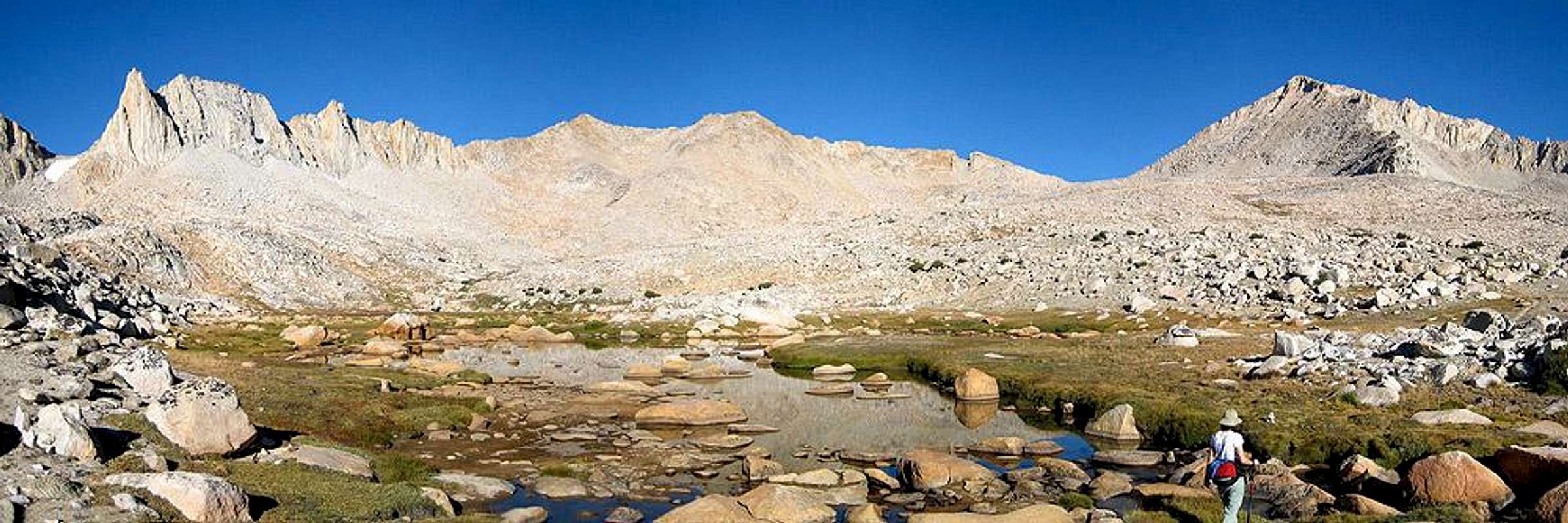
hgrapid - Oct 24, 2015 12:22 pm - Voted 10/10
east of Bishop?You noted the trailhead is east of Bishop, but the mountain is far to the west.
mrchad9 - Oct 24, 2015 10:57 pm - Hasn't voted
Re: east of Bishop?Fixed it. Im always mixing those up on road directions ever since moving from the East Coast.
chugach mtn boy - Nov 22, 2015 12:38 am - Voted 10/10
Re: east of Bishop?Sadly, you will do that for the rest of your life.