
|
|
Mountain/Rock |
|---|---|
|
|
41.02130°N / 114.077°W |
|
|
10716 ft / 3266 m |
|
|
Overview
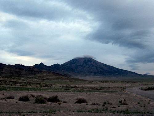
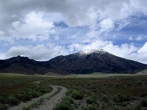
Pilot Peak is a dominant peak that is noticed most readily as you drive from Wells Nevada towards Wendover. It is easily the most beautiful mountain in the whole region and it is one of the "ultra" peaks found in the lower 48, one of 57 with that designation. It has over 5700 feet of prominence, which makes it the 32nd most prominent peak in the USA. It is not a fun peak to climb since it is well guarded by talus slopes that make you earn your way to the top but once at the top, the reward is one of the finest views anywhere. Most that climb this one say once is enough and that includes me.
The name “PILOT PEAK” is attributed to Captain John C. Fremont. In 1845 during Fremont’s 3rd expedition, the explorer and his party were traveling west along the south shore of the Great Salt Lake, searching for a shorter route to the central Great Basin and onward to California. From the summit of the Cedar Mountains in Utah, Fremont’s party could see one very high peak to the west beyond the expanse of the salt desert. To cross the desert with the whole expedition and not know if they would find water was much too risky. Fremont sent famed scout Kit Carson along with three other men ahead on the best horses with extra supplies. Nearly 24 hours later, Fremont was able to see with his telescope the smoke from the signal fire built by Carson and the advance scouts. Fremont and the remainder of the expedition made it safely across the salt flats to the life-saving waters and abundant grass at the base of Pilot Peak. The water they came to is at Pilot Ranch, about 8 miles north of the turnoff to Miners Canyon. In 1846, the ill-fated Donner party followed this same route. The large spring at the ranch is called Donner Spring.
On the summit are half a dozen rock alignments and stone windbreaks. The rock alignments were thought to be Civil War-era mirror signaling stations. We found a mailbox on top with the registers inside of it when we were there but I didn't want to leave a letter or package of any kind to be mailed since I don't think it is on the USPS route.
Originally credit goes to grandwazoo for creating this page. He handed it off to me with the directions that I should do my best to make him proud. I'm still working at it so will try and keep this page updated.
Signature pic in upper right taken by byates.
Getting There
Miners Canyon Trailhead
From Exit 4 in Utah on I-80, head north on a paved road for 1.8 miles Road Sign (road turns right to Bonneville Salt Flats) stay straight onto the bladed gravel road. Continue for 0.8 miles to another intersection Road Sign, stay left and follow for another 15 miles while crossing into Nevada. The Miner's Canyon turnoff is at the second cattle guard, which is also the state line in which you would cross back into Utah. Turn left onto the dirt 4 wheel drive road and follow for about 4.5 miles to the terminus of the road. The end on the road is past the old Mine and beyond all springs. Road End
ScottyS pic
Red Tape
The peak is located on BLM lands.
No red tape if approaching from the East (Miners Canyon)
Private lands are at the foot of the mountain on the west side and are to be avoided.

When To Climb & routes
Generally, fall is the best time to visit this mountain. Snow issues in the Spring and winter could be problematic although if sufficient consolidated snow present, the talus aspect might be easier at that time. Summers get extremely hot in this region and Winters will probably add the 4.5 miles of 4 wheel drive road to the total trail travel.

On the summit
Most climb this peak from Miner's canyon (see the Miner's Canyon Route at left) and a few try it from the east. Talus is the common denominator and trying to minimize the amount of talus you have to deal with is what most routes are "built" around. Study the summit log entries and you will get a feel for how most have gone up this pile of rubble. I feel that there is no perfect way but just ways that may work better than others. There are no trails but your experience will vary. If you find a great way up, please share it with the rest of us. (Dean)
Peakbagger.com has a great page for this mountain. Lots of trip reports and some GPS tracks. The summit log there indicates well over 50 people have climbed this with some already this year so far in 2015. Lists of John also has a summit log which lists some people who aren't signed into the peakbagger log.

Register page
Camping
A few primitive camping areas can be found near the old Mine and at the springs.
It is possible to car camp at the end of the road Road End. On two occasions, I have camped not far from the 2nd cattleguard on the early section of the road. (Dean)

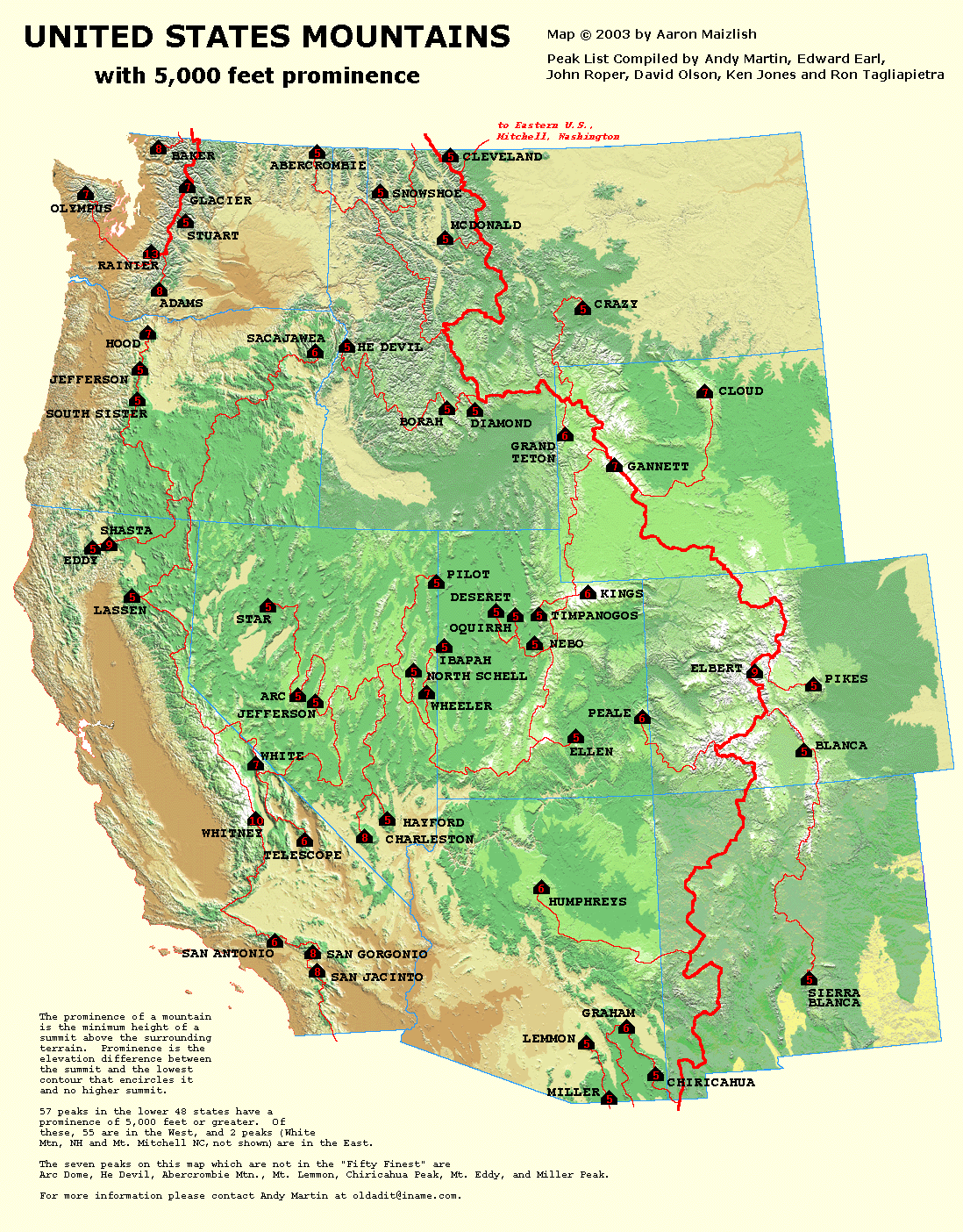
PIlot Peak one of the 57 USA prominence peaks
Pilot Peak is also one of the sought after prominence peaks in Nevada as it ranks #4 on the list. Pilot Peak stands out rather dramatically from valleys around it, as it has 5726 feet of prominence. This prominence puts it in an elite group of peaks in the USA that have a prominence of over 5000 feet and those can be seen on this neat MAP HERE. If you don't understand what prominence is all about, here is a good explanation. Adam Helman recently authored a book completely dedicated to prominence.
Adam also made a trip to Pilot Peak in Sept. 2007 and that report can be found HERE.
Mountain Conditions
Click HERE for current weather conditions in Wendover Nevada.
A bit of history (a must-read)
Pilot Peak presents challenges for modern-day, historical travelers
6/14/2007 (From the Tooele Newspaper-original article no longer available via the newspaper link)
by Jaromy Jessop correspondent
In last week's article we left off with Captain Stansbury and his survey party recouping their strength at the base of Pilot Peak in October of 1849 after nearly perishing in their crossing of the salt desert from the north end of the Great Salt Lake. Stansbury commented that heavy clouds hung over the mountain (Pilot Peak) for the three days that they were there. When Stansbury gazed up towards this summit he had no idea that about 30 years later, an intrepid explorer, mountaineer, and surveyor from the U.S. Coast and Geodetic Survey would build a trail up to the summit of this rocky, inaccessible peak and establish a camp on its 10,716-foot summit. This gentleman's name was William Eimbeck.
Eimbeck was charged with determining elevations along the 39th parallel of latitude as part of a great survey. To do this he had to establish trails to the summits of numerous peaks throughout the deserts of Nevada, Utah, and the mountains of Colorado. When these trails were built, he and his crew would "occupy" the summit of the mountain with all of their instruments, the most important of which was the heliograph.
Pilot Peak
Take Pilot Peak as an example of what it meant to occupy a peak. In the summer of 1889, Eimbeck arrived in Salt Lake City from Washington D. C. where his offices were located and made arrangements for the transportation of his equipages, mules, instruments, and other supplies to Tecoma, which was a station on the Central Pacific Railroad about 35 miles north of Pilot Peak. It is interesting to note that Tecoma has now vanished just like Kelton, Terrace, and Lucin, which were all towns along the first transcontinental railroad route. From Tecoma, he planned and supervised the construction of 30 miles of roads down the eastern flank of the Pilot Range and a pack trail to the summit of the peak. He notes that "The un-usual rocky and inaccessible character of the peak presented formidable obstacles to rapid progress" It took his party most of May and June to complete these roads and the pack trail to the summit of the peak.
July 1, 1889, found William Eimbeck and the members of his party encamped on the summit of Pilot Peak. He and those in his charge busied themselves with the following chores. They made Observations of horizontal directions to points distant -- keep in mind that while he was on Pilot Peak with his party, many lesser peaks such as Newfoundland, Scipio (Fool Peak in the Canyon Range near Delta), Coon & Lewiston Peaks (Oquirrh Mountains) and others were occupied with Heliograph teams to send signals back to the originating point Pilot Peak so that the distances and elevations could be measured. They took Double Zenith distances and two of the longest lines of the Utah work were included which were Pilot to Jeff Davis (Wheeler Peak) and Pilot to Nebo. Both lines were approximately 148 miles long.
Climbing to the summit
I attempted a climb of Pilot Peak in April of 2004 in search of the Eimbeck trail and I was unsuccessful on several counts. First of all, I didn't find the trail that Eimbeck built for his pack mules in 1889, even though some locals swear it is still there on the east side of the mountain and to this day provides good passage through the horrible talus rock slides. My brother and I started from the old chimney just east of Pilot Peak and headed up the ridge that looked most promising. We traveled through dry cheatgrass/sagebrush, through a burned-out skeletal forest of bleaching junipers, up what we termed "Boulder Hell," and then across several large snowfields. I noticed some enormous limber pine trees up there that were very interesting. These trees were huge around the trunk, one being at least 10 to 12 feet in circumference around its trunk, and some were very tall. These trees bore evidence of fighting an age-old battle with the elements as they were in some cases gnarled and twisted in grotesque manners.
As we climbed even higher on the mountain we looked back across the Salt Flats toward the Silver Island Range and it was an unbelievable sight because from this elevated position you could still see the marks that the emigrant's wagons left on the salt when they crossed it 158 years ago. These tracks are plain as day in the salt when viewed from above and they run from the north tip of the Silver Island Range through Donner Pass, straight across the hardpan to Donner Springs.
We had been hiking, climbing, getting scratched, sunburned and just plain worn out for about six hours due to the snow, talus, vegetation and lack of any trail but we were getting very close to the summit. The normal route up this peak is via Miners Canyon and the north ridge. As always, I chose a different route and we paid dearly for it.
At about 8 p.m. we found ourselves only 800 feet in elevation away from the veritable summit but I remembered my "Don't hike in the dark if you can avoid it" policy and as the sun began to set we made the regretful decision to abandon the peak for another day and we went down to the car over the boulders, pines, and bushes.
As I stood there at Donner Springs gazing up at Pilot Peak I remembered this hike and told myself that we would meet again, Pilot Peak and I that is, and the next time I would conquer it. I also imagined a pack train of 20 heavily loaded mules lumbering along the trail through the broken rock, pines, and talus fields up to the summit of Pilot Peak in 1889 to establish that remote mountain station. After a bit of daydreaming on that subject my thoughts returned to Captain Stansbury and his exploring party. They had been at the spring for three days and they were preparing to follow Capt. John C. Fremont's trail back across the salt flats to Salt Lake City.
Fearing the trail
Stansbury stated that "some little preparations" were necessary before attempting a crossing of that great obstacle. Stansbury did not want his outfit to suffer and nearly perish the same way they did on the trip out to Pilot Peak.
Great fear and apprehension must have gripped the men of Stansbury's party and certainly the mules, at the prospect of once again striking out into the salt desert. On the return trip, they basically followed Hastings's trail or cut off. Due to recent rains, the salt desert was a complete mess. "From this point we traveled on until past midnight, over a level mud-plain, lighted by the rays of the moon, which struggled through a mass of dark and threatening clouds. The wind was fresh and cold and the mud soft and tenacious, making traveling very slow and fatiguing. During the night we passed five wagons and one cart which had stuck fast in the mud and been necessarily left by their owners, who, from appearances, had abandoned everything, fearful of perishing themselves in this inhospitable desert ... The carcasses of several oxen lying about on the ground satisfactorily explained the whole matter. In attempting to cross the plain, the animals had died from exhaustion and want of water, and the wagons and their contents had, of course, to be abandoned." All of these things were probably the remains of the leavings of the Donner Party who crossed on this trail several years before Stansbury.
Stansbury went on to describe a horrible and somewhat terrifying night on the desert as the mud was ankle deep and when they stopped finally to sleep for a bit, there was no place to lay a blanket and no wood to burn or water for making coffee. Eventually, the party arrived at the western base of the Cedar Mountains and camped there due to the fact that they were completely worn out and this area provided the first wood for fuel for over 70 miles from Pilot Peak. In the morning they awoke to several inches of fresh snow and they crossed Hasting's Pass, Skull Valley, rounded Timpie Point and then made camp in what is now Grantsville. He described a noble spring of fresh cold water with an abundance of grass and an expansive grove of large willows for fuel. Stansbury stated, "This valley is called Tuilla Valley by the Mormons, The grass is very abundant and numerous springs are found on both sides of it."
It is interesting to consider this expedition in 1849 which was the first group of white men to ever circumnavigate the Great Salt Lake by land. The Indians must have watched this group with amusement at times from stealthy positions, wonder why in the world they were out there. It is also interesting to study more about the man whose name is found all over Tooele County at places such as Stansbury Park, Stansbury Island, and the Stansbury Mountains just to name a few. A complete chronicle of this adventure is found in his official report "An Expedition to the Valley of the Great Salt Lake of Utah" by Howard Stansbury, 1855. This wonderful volume can be found at most public libraries in the State and it is also available for anyone to read online via Google Books. Stansbury was a masterful writer and it is a very enjoyable thing to read his work.
Last Updated ( 6/14/2007 )
10 Ultras in 10 days
This will remain one of the more amazing feats I have heard of in the realm of ultra peaks. Check out the link to find out a bit more. Considering the distances involved and the amount of hiking this effort entailed, this will remain to me as one of the outstanding ten-day efforts ever put together here in the west.
LINK

ScottyS - Feb 27, 2008 11:37 pm - Hasn't voted
Old TreesAs a matter of note, Pilot Peak, like many Great Basin peaks, is home to a few old trees. It has a diverse population in the sub-alpine zone, but down lower in the middle of the Pinyon-Juniper band lies the oldest known (to date) living Pinus monophylla (Singleleaf Pinyon Pine). At over 900 years old, it has certainly seen a lot of sunrises over Lake Bonneville from it's protected perch. It was discovered and dated by dendrochronologists Scotty Strachan and Franco Biondi in 2005.
Dean - Feb 28, 2008 12:25 pm - Voted 10/10
Re: Old TreesBy any chance did you guys get a pic of that tree. It'd be a nice addition to the page. I love the ancient trees of the great basin.
ScottyS - Mar 4, 2008 1:32 pm - Hasn't voted
Re: Old TreesYep, I have a pic. Will upload it now....
gimpilator - Jul 18, 2016 6:58 pm - Hasn't voted
Donner PartyIt is noteworthy that the original wagon tracks of the Donner Party are visible in the salt flats below the peak. If you want to know more about this, just let me know.
koko head - Dec 30, 2019 8:06 pm - Hasn't voted
Climbing routesI have climbed pilot peak 10+ times on 4 different routes and have found the descriptions accurate. The nice thing is you can’t go wrong. You will hate any route you take and swear there is an easier route. miners canyon is as good as any. Talus fields are not a good description There are a few talus slopes but mostly expansive boulder fields that you scramble up some 4 point while wondering if you will become the next Aron Ralston. The trail created by William Eimbeck in 1889 is facinating. It is in railroad canyon not on the ridge but in the basin itself to the north of the described route Most of the trail was destroyed by a massive landslide 10 years ago making the canyon all but impassable but if you find it you will still not use it anyway as small trees and brush have appropriated it for their use.( google earth 11/20/2000 image coordinates 41 01 35. 94 N. 114 04 12. 06 W) Eimbeck trail visible in 9/11/ 2010 image but gone by 10/05/2013 image ( except for some forensic diagonal scaring) If you are interested however in seeing the trail-after reaching the top from miners canyon continue north down the ridge for several hundred yards and bear right There a small portion of the hard earned trail survives.
richh - May 26, 2020 2:37 am - Hasn't voted
Re: Climbing routesRead about the Eimbeck Trail several years ago, and wanted to try it. I could see several sections on the Google Earth 10/5/2013 image. Around 9000msl, found a section 0.6 mile long with about 26 switchbacks; estimated grade only 15%! Must have made it easy in its day. But even that visible section now has numerous large logs across it. I'll now stick to one of the proven routes.
koko head - Dec 30, 2019 8:40 pm - Hasn't voted
West face. Last climbed 7/2018My favorite route is the west face Pure simple ecstasy See the mountain climb the mountain. Route and approach. Google earth the mountain from the west and find the peak. Follow that basin down to where it intersects a very primitive rocky road at a stream Follow that road to the northwest to where it intersects the pilot valley road. Most roads are private and the people private so note the turns carefully as there are no signs and few landmarks When you start your climb at the stream stay on the south side of the stream and bushwhack through the trees til you reach the rocky basin and can see the top. No water no cell phone no people and large tippy rocks on an occasional 4 point summit push. Miners canyon is probably slightly easier. I find the trip down to be as long and slightly harder as there is a lot of boulder hopping