
|
|
Mountain/Rock |
|---|---|
|
|
38.95030°N / 120.1365°W |
|
|
8640 ft / 2633 m |
|
|
Overview
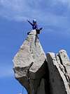
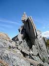
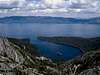
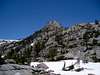
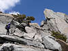
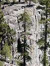
For those of us living in Sacramento, it is nice to have such a gem of a feature practically in our backyard. This good-looking granite tower rises one mile west of Eagle Lake near Emerald Bay. The Eagle Lake Buttress offers several short pitches of varying difficulty from 5.5 to 5.10. Really good granite! Great views! Almost has a Tuolumne feel. This a great climb to satisfy the alpine jones and still have the weekend for family, Home Depot, or whatever else calls you.Follow the trail to Eagle Lake, cross the Lake's outlet and go right around the Lake and up to a talus-filled ravine that leads to the ridge. Follow the ridge to the base. Mountaineer's Route is Class 3-4. From the southwest edge of the buttress, follow slabs to the notch and continue along the ridge to the top. Short rope, small rack (few small cams).
 |  |  |  |  |
Getting There
50 east to 89 north, 8.5 miles, or80 east to 89 south, 9 miles to Emerald Bay. Eagle Falls Trailhead.
 |  |  |

Red Tape
Main trailhead parking is $3. Park for free on the 89. This is a busy parking lot, but you lose the crowds after Eagle Lake.When To Climb
May-November. This area is particularly pretty with all the snow this year. No snow shoes required as of May 30.Camping
A wilderness permit is required year round for day and overnight trips. Day use permits avaiable at trailhead during the summer. Otherwise pick one up at the Pacific Ranger Station, on Hwy 50, 4 miles east of Pollock Pines, Left on Mill Run Road turnoff, (530) 647-5415, or Lake Tahoe Basin Management Unit in South Lake Tahoe, 35 College Drive.Mountain Conditions
Desolation WildernessWeather