
|
|
Mountain/Rock |
|---|---|
|
|
38.84430°N / 120.158°W |
|
|
El Dorado |
|
|
Hiking, Mountaineering, Scrambling, Skiing |
|
|
Spring, Summer, Fall, Winter |
|
|
9983 ft / 3043 m |
|
|
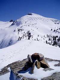
Pyramid Peak Overview
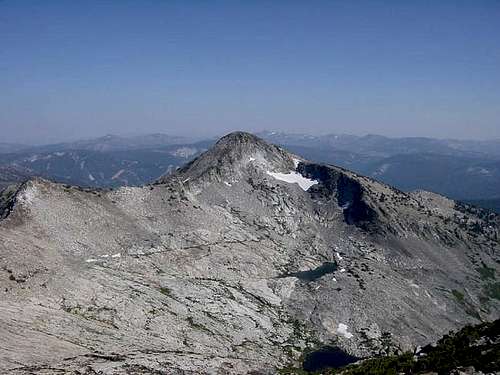
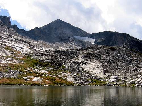
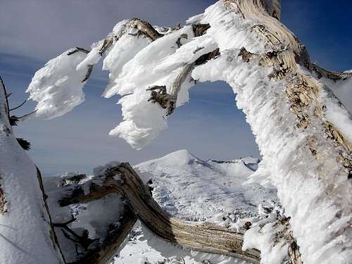
Located at the southern end of the Crystal Range, at 9,983 feet Pyramid Peak is the alpha peak in California’s Desolation Wilderness Area. Named after it’s unmistakable shape, from a distance it looks like a huge granite pyramid. Pyramid Peak is a prominent Tahoe landmark, which can be seen from as far away as the Coastal Range, and on clear days it can be clearly seen from Sacramento, almost 100 miles away. I have seen this peak from every peak I have climbed in the Tahoe area, and I have seen it from as far away as Highland Peak near the Ebbetts Pass Area.
The West Ridge
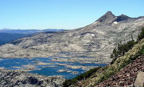
From the summit, the views seem endless. On clear days looking west, the Coastal Range rise on the horizon and I bet on the clearest days you can make out the city of Sacramento. Looking north the rest of the Crystal Range dominate the view, with Mount Agassiz and Mount Price just to the north. Further north Granite Chief and the rest of the peaks of the Granite Chief Wilderness rise above the horizon. Looking west give you perhaps the best view of the Lake Tahoe Basin. Right below you is Lake Aloha and the rest of Desolation Valley. You can also see Dicks and Jacks Peak and Mount Tallac. Father off to the east is the Carson Range with Mount Rose to the north and the twin "dunes" Jobs Sister and Freel Peak anchoring the southern end. In my humble opinion the best view is to the south. In the foreground is Stevens and Red Lake Peak with Round Top just a on the other side of Carson Pass. On the Southern horizon is Highland Peak with Sonora Peak just a little further south.
Overview of Principal Climbing Routes on Pyramid Peak
Pyramid Peak can be climbed many different ways. The most basic ways are class 2 hikes, like the ones listed below. But there is always the opportunity to spice up the routes if you choose to with a little bit of class 3 or sometimes class 4 if it suits you. Like many Sierra peaks, Pyramid Peak is covered by large talus and you will find yourself boulder hopping, so please test your footing and hand holds before putting all your weight on the rock.
• West Ridge (Lake Sylvia): Class 2
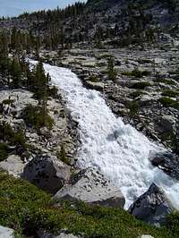
This is one of the longer routes up Pyramid Peak at about 6 miles one-way, with 3300 feet of elevation gain. The route starts at the Lyons Creek trailhead off of Wrights Lake Road on the west side of Desolation Wilderness. Most of the route follows the well maintained Lyons Creek Trail to Lake Sylvia, Once you reach the lake the fun begins with only about a mile to go, but with about another 2000 feet to climb. From Lake Sylvia, climb up to the low point of the West Ridge, to the south of the lake. Once you top out, just follow the ridge to the summit.
• Pyramid Couloir: Class 2-3
This route is best done in spring when the Wrights Lake road opens. The couloir is a kinda/sort of variation of the West Ridge Route. Follow the same directions as the West Ridge route up until you reach Lake Sylvia. When you reach the lake follow the trail on the left side of the lake and follow a use trail or go cross-country to the upper unnamed tarn below the northwest face of Pyramid Peak. Stay to the right of a small group of trees and the head to the obvious couloir. The climb up the couloir is pretty straightforward and the snow angle varies from 30-50 degrees with the steepest section at the top. After toping out the couloir follow the west ridge to the summit.
• Rocky Canyon/South East Ridge : Class 2
This is the shortest and most direct route up Pyramid Peak. It also has the most elevation gain of any climb in the Tahoe area at 4,083 feet of gain. Since it is the shortest way to the top, it is also the most popular, so arrive early due to limited parking at the trailhead. From the trailhead, which is nothing more than a turn out off Highway 50 between Strawberry and Twin Bridges follow a steep use trail up to about 8,000 feet. From there the route becomes obvious when the summit area comes into view.
• Horsetail Falls / East Face Couloir : Class 2-3
This is one of the more direct routes up Pyramid Peak, but is also one of the biggest climbs with about 3863 feet of elevation gain. From the Pyramid Creek (Twin Bridges) Trailhead hike up the Horse Tail Falls trail for about 1.5 miles to the base of the falls and the end of the trail. At the point head left and scramble up to the low point in the ridge. From there the route becomes obvious when the summit area comes into view.
• East Ridge : Class 2-3
The start of the route is the same as the Horsetail Falls / East Face Couloir route, up until you reach Horsetail Falls. Instead of heading left after the falls keep following Pyramid Creek past Avalanche, Pitt, and Ropi Lakes. Keep Following the creek until you reach Pyramid Creek, from there head east following a small creek that drains from a small lake at the base of Pyramid Peak. From there the route becomes obvious when the summit area comes into view.
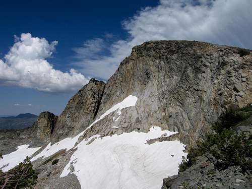
 The west face.

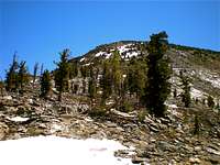
Lyons Creek Trailhead
Getting To Pyramid Peak
Airports
· San Francisco International Airport : is located in San Francisco and is about three and a half hours form Lake Tahoe. Not as convenient as Sacramento or Reno-Tahoe, but it would be a better option for international travelers. Other options in the Bay Area are Oakland International and San Jose International Airports.
· Sacramento International Airport : is located north west of Sacramento, and is the biggest airport within two hours drive of Lake Tahoe.
· Reno-Tahoe International Airport: is located in Reno and is the closest major airport to Pyramid Peak and the whole Lake Tahoe Basin.
· Lake Tahoe Airport: is located in Tahoe Valley between Meyers and the city of South Lake Tahoe, but it is a small airport and probably more expensive to fly into.
Getting to Pyramid Peak From Sacramento

Typical Desolation Wilderness Marker.
· Lyons Creek Trailhead : Take U.S. Highway 50 east to South Lake Tahoe. This is a great drive in the summer time. During winter it is subject to closures during storms and when it clear it is clogged with traffic heading up to ski at one of the many ski areas that ring Lake Tahoe. Highway 50 makes a nice gradual climb up the west side of the Sierra Nevada Range. After driving 5.1 miles east the tiny town of Kyburz you will come across Wright Lake Road. Turn left here, and drive for 4 miles up the narrow single lane road until you get to the trailhead, which will be on the right side of the road.
· Rocky Canyon Trailhead : Take Highway 50 as shown above, but do not turn left on Wrights Lake Road. Instead continue driving east on 50, through the small town of Strawberry. After about .9 miles past Strawberry (Strawberry Lane), look for a small sandy turnout, on the right side of the road. Pull over here this is the trailhead. This is not an official trailhead, so you will have to get your permit at another trailhead or at a ranger station (see the red tape section).
· Pyramid Creek (Twin Bridges) Trailhead: Take Highway 50 as shown above, but do not turn off at the turn off at Rocky Canyon. Instead continue driving east on 50, through the small town of Strawberry. After about 1.6 miles past Strawberry (Strawberry Lane). The trail head is an obvious parking lot on the left hand side of the road, right before an horseshoe bend in the road that begins a climb up to Echo Summit.
· An alternate route from Sacramento would be to take Interstate 80 east towards Truckee and Reno and follow the directions listed below for Truckee. Interstate 80 is a nice route head up. It travels through Donnor Pass to other climbing and hiking areas such as Castle Peak and Mount Lola.
Getting to Pyramid Peak From Reno and Carson City
· Lyons Creek Trailhead : Follow the directions to the Pyramid Creek (Twin Bridges) Trailhead but, drive 5.5 miles until you reach Wrights Lake Road. Turn right here, and drive for 4 miles up the narrow single lane road until you get to the trailhead, which will be on the right side of the road.
· Rocky Canyon Trailhead : Follow the below directions but, drive .8 miles past the Pyramid Creek (Twin Bridges) Trailhead to a small sandy turnout on the left side of the road. Pull over here this is the trailhead.
· Pyramid Creek (Twin Bridges) Trailhead : Take U.S. Highway 50 west to Stateline and South Lake Tahoe. When you get to Glenbrook Highway 50 turns south and follows the east shore of Lake Tahoe. Drive past the casinos in State Line in to South Lake Tahoe. Continue on Highway 50 until you reach the junction with Highway 89. Turn left here and follow the now Highway 50/89 south past the airport to the town of Meyers. Shortly after passing the agricultural fruit check station, you will pass a junction, where the two highway separate. Highway 89 heads off to the left, while you continue straight on 50. After the junction, drive 10.8 miles up and past Echo Summit until you reach the horseshoe bend where the large parking lot on the right side of the road that is your trailhead.
Getting to Pyramid Peak From Truckee
· Lyons Creek Trailhead : Follow the directions to the Pyramid Creek (Twin Bridges) Trailhead but, drive 5.5 miles until you reach Wrights Lake Road. Turn right here, and drive for 4 miles up the narrow single lane road until you get to the trailhead, which will be on the right side of the road.
· Rocky Canyon Trailhead : Follow the below directions but, drive .8 miles past the Pyramid Creek (Twin Bridges) Trailhead to a small sandy turnout on the left side of the road. Pull over here this is the trailhead.
· Pyramid Creek (Twin Bridges) Trailhead : Take Highway 89 south from Interstate 80. This is a wonderful and scenic drive that takes you past Squaw Valley and along the west shore of Lake Tahoe. Shortly after passing the Tahoe Keys Highway 89 and Highway 50 connect in the city of South Lake Tahoe. Follow Highway 50/89 south past the Lake Tahoe Airport and Lake Tahoe Golf Course to the town of Meyers. Shortly after passing the agricultural fruit check station, you will pass a junction, where the two highway separate. Highway 89 heads off to the left, while you continue straight on 50. After the junction, drive 10.8 miles up and past Echo Summit until you reach the horseshoe bend where the large parking lot on the right side of the road that is your trailhead.
Red Tape
Permits
Plenty of red tape here. First off, you need a permit to enter Desolation Wilderness year round. Whether you are going in as a daytrip or an overnighter. For day trips during the summer, the permit is free and you can pick it up at the major trailheads or at one of the nearby ranger stations. For a day trip during winter the trailheads are shut down and you must pick up your permit at a ranger station. If you are planning on going into Desolation overnight you must pick up your permit at one of the ranger stations listed below and you are subject to fees.
Quotas
There is a quota for overnight users from the Friday before Memorial Day to September 30th of every year due to heavy use of Desolation Wilderness. The quota is based on the number of people entering the wilderness each day, and their first night's destination zone. 50% of the quota is based on reservation and the remainder is based on first-come, first served on the day of entry. The quota system does not pertain to day trips or off-season overnighters.
Ranger Stations
West Side Entry
PACIFIC RANGER DISTRICT
Located four miles east of Pollock Pines on Highway 50 (Take a left at the "Fresh Pond" sign).
7887 Highway 50, Pollock Pines, CA 95726
Phone: (530)644-6048
Winter: Weekdays only. Monday through Saturday as of late April.
Summer: 7 days a week, 8:00 a.m. to 4:30 p.m. through October.
East Side Entry
LAKE TAHOE VISITOR'S CENTER
Located three miles north of the Highway 50/89 junction at South Lake Tahoe, on Highway 89.
Call for hours, phone: (530)543-2674
Open summer only.
LAKE TAHOE BASIN MANAGEMENT UNIT
Located two miles east of the Highway 50/89 junction in South Lake Tahoe on Highway 50. From the highway turn right on Al Tahoe Blvd. and then turn right at first signal.
35 College Drive, South Lake Tahoe, CA 96150.
Phone: (530)543-2600
Miscellaneous Red Tape
1) Campfires are prohibited inside Desolation Wilderness.
2) The maximum number of people per group, day trip or overnighter is 12.
3) Dogs must be on a leash at all times.
4) Check in with the ranger stations for campground restrictions.
Camping and Lodging near Pyramid Peak
Camping
Lake Tahoe is an outdoor persons paradise, but it certainly isn’t much of an wilderness area. The Tahoe area is dotted with towns and ski resorts and the associated baggage they bring. There are scores of campgrounds both private and public that ring around Lake Tahoe, where you can pull up or take a tent to. The Lake Tahoe Basin Management Unit has an online list of developed campsites in the Lake Tahoe Basin.
There are also plenty of developed campgrounds along Highway 50, between Placerville and Tahoe. The closest ones being, Lovers Leap and Sand Flat along Highway 50. If you choose to car camp at any Lake Tahoe area campground during the summer months, I highly recommend getting a reservation well in advance. No matter where you camp at Lake Tahoe be aware that there is a Bear problem so you might be defending your food if you don’t secure well enough. The bright side is that the Bears are not the seasoned pros that you run into in Yosemite and they haven’t figured out how to break into cars yet.
Since Pyramid Peak is entirely in Desolation Wilderness, finding a backcountry campsite is not an issue. If you camp outside the wilderness boundary, an overnight permit is not need. Just be sure you don’t camp on private property and you obey any campfire restrictions. There are plenty of good-looking spots along the Lyons Creek Trail, with good access to water. If you choose to camp inside Desolation, you will need a overnight permit and you are subject to a confusing series of fees, and keep in mind that campfires are not allowed inside Desolation Wilderness.
Lodging at Lake Tahoe
Lake Tahoe, along with being an Outdoors person’s heaven it is also a tourist magnet. Because of numerous ski areas, mild summers and casinos there are countless motels, hotels and cabins. They range from lowly motor lodges to casino motels to luxury resorts. This website is useful in planning a trip to the Tahoe area no matter what time of year it is.
When To Climb Pyramid Peak
Pyramid Peak can be climbed year round. I recommend only climbing it during the winter if you have plenty of winter hiking, camping, and climbing experience.. During the summer months and early fall, the routes should be snow free. Usually the heavy snows start in November. Highways 89 and 50 generally stay opened, only closed during strong snowstorms. So accessibility is never really and issue, Wrights Lake Road might be a different story. It is a minor, single lane road and I’m sure it doesn’t get plowed.
I think the best time to climb and hike in the Lake Tahoe area is late July to late October. But late July (in normal years) most of the snow is melted out and Mosquitoes have cleared out for the most part. During the summer months temperatures rarely get about 80° F or drop below 40° F at night. By November the weather changes dramatically with high temperatures around 47° F and lows about 22° F.
Recommended Equipment for Pyramid Peak
For a Summer Trip I Recommend the Following Equipment
· Map & Compass
· Knife
· Matches/Lighter
· Sunglasses
· Sunscreen and Lip Balm
· First Aid Kit
· Food (extra food for emergencies)
· Headlamp and extra batteries
· Signaling Device (whistle and/or mirror)
· Gloves and Mittens
· Beanie, Sun Hat
· Wool or Synthetic Clothing
· Sleeping Bag - comfortable to 30F or 10F (in Winter)
For Winter I Recommend The Above Equipment Plus the Following Equipment
· Down or Synthetic Parka
· Ice Axe
· Helmet
· Boots
· Gaiters
· Crampons
· Down Parka, Pants, and Mittens
· Double Boots or Over Boots
· Avalanche Beacon & Probe
· Snow Shovel
· Snowshoes or Skis
Pyramid Peak Conditions
Caltrans Current Highway Conditions.
DESOLATION WILDERNESS
Lake Tahoe Basin Management Unit
El Dorado National Forest
Updated Weather Information

Etymology
”Pyramid. Some twenty-five features in California-mostly peaks, rocks, and hills-are called Pyramid, because of their shape. Among these are two high peaks in Sequoia National Park and in Inyo County, and Pyramid Head on San Clemente Island. For the application of the name Pyramid Point to Point Lobos, see Point Lobos [Monterey] in the entry Lobo"
Erwin G. Gudde, California Place Names
”Pyramid Peak Quadrangle
“We continued along the Carson Road, which here bends off considerably to the south-east and descends some 200 feet in the next two miles. This is the low depression in the ridge which is seen at the head of Weber Creek, from Placerville hill, and over which Pyramid Peak and its group are seen in the distance. Here the Diamond Springs Road branches off on a divide to the south….
“Immediately on starting, our road re-ascended the ridge, at which point we took bearings on Pyramid Peak and several other points….
“The views obtained to the north are very grand; all the creeks falling to the American have broken up the country in the roughest possible manner, while beyond them Pyramid Peak towers aloft, forming a magnificent back ground to one of the most striking scenes on the road.” (Goddard, Report, 98-100.) “Pyramid Peak “appeared on the a Goddard map. (Goddard, South.)
“Climbed Pyramid Peak … up steep slope to summit…. Several pretty little lakes near…. The ridges near Lake Tahoe apparently all volcanic.” (Brewer, Field Notes, August 20, 1863.) “On a strip of wood, many names are carved. Among the rest, the following inscription. ‘Pyramid Peak is 9413.1 ft. above the sea. Measured Oct. 19th 1862 by W.W. Harvey, C.E.” (Brewer, Observations, August 20, 1863.)
Alfred R Conkling wrote: “I have condensed the following extract from Professor Joseph Le Conte’s paper on’Ancient Glaciers of the Sierra,’ as he has studied the glacial phenomena thoroughly: ‘ Between the Eastern and Western Summits lies a trough fifty miles ling, twenty miles wide, and 3,000 to 3,500 feet deep. This trough is Lake Valley. It was formerly occupied by a great glacier rising near Pyramid Peak, filling Lake Tahoe, and escaping northwest towards the plains.’
“The predominating rock in the western summit is granite. But igneous rocks such as basalt, diorite, and phonolite have broken through the granite in several places. This range may be fitly divided not the Pyramid Peak ridge, the Tallac Peak ridge, the Twin Peak ridge, and the ridge north of Truckee Canon.
“Beginning on the south, the Pyramid Peak ridge consists chiefly of granite. This is the westernmost ridge of the western summit, and its southern boundary is the American Fork Canon, a narrow, windy valley with precipitous sides composed of gray granite. The peak itself is a mass of coarse-grained, yellowish granite in the form of a pyramid rising about 300 feet above the ridge-line. The altitude of Pyramid Peak is 10,003 feet. The north side of the peak is much steeper than the other sides. Angular fragments of granite cover the slope of Pyramid Peak for a distance of a quarter to a half a mile from the top. There is a small grass patch on the northeast side of the mountain. The eastern declivity of Pyramid Peak passes gradually into the ‘Devil’s Basin’[Desolation Wilderness], a vast amphitheater of granite, probably formed by glacial agency, and containing a series of lakelets. A serrated ridge forms the eastern boundary of this basin. The rock is grayish granite, with large, dark specks of the same rock disseminated through it at the point where the Placerville road crosses the western summit [Echo Summit]. At first sight these spots presented the appearance of hornblende, but on close examination it was found that they were only a darker variety of the granite, although the forms were six-sided.” (Wheeler, Report, 1291-93. See Desolation Wilderness."
Barbara Lekisch, Tahoe Place Names
Additional Pyramid Peak Information
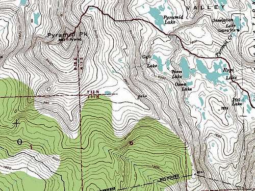
· USGS 7 ½-minute Pyramid Peak
· USFS Lake Tahoe Basin Management Unit Map
· Tom Harrison Maps: Lake Tahoe Recreation Map
. Tom Harrison Maps: Desolation Wilderness Map
Links
External Links
· Keep Tahoe Blue
· Lake Tahoe Average Temperatures
Useful Summitpost Links
· Lake Tahoe Basin
· Tahoe OGUL Peak List
· Sierra Nevada
· Desolation Wilderness Area
· Sierra Peaks Section (SPS)
· California Wilderness Areas


Ajay - May 24, 2005 8:32 pm - Hasn't voted
Untitled CommentRoute : Rocky Canyon.
Finding the trail: Rocky Canyon is the first water course on Hwy 50 heading north just after passing the last of the houses of Strawberry. It is not marked. Trail starts about 200 yards past the water course and it cannot be seen from the Hwy. Climb up on the slope look for it. Its a small trail but distinct and easy to follow once you're on it.
Crossing the canyon at ~ 7200 feet looked fairly treacherous due to the large volume of meltwater this season. We found a dead tree across the creek about 500 yards upstream of what may be the usual crossing point, and we were able to make a safe crossing.
Once across, there was snow cover almost all of the way up. Snow was fairly soft, but we made good speed without snowshoes.
Ski descent was on slushy snow, and we returned by the same route.
Diggler - May 17, 2006 12:19 am - Hasn't voted
phone number obsoleteThe one listed under 'Mountain Cond.': Lake Tahoe Basin Management Unit Phone: (530) 573-2694
T. White - Sep 5, 2021 8:09 am - Hasn't voted
Caldor FireNote: As of September 2021, access and trail conditions may vary due to damage from the Caldor Fire.