
-
 12070 Hits
-
 77.48% Score
-
 8 Votes
|
|
Mountain/Rock |
|---|---|
|
|
43.94800°N / 71.479°W |
|
|
3040 ft / 927 m |
|
|
Overview
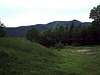
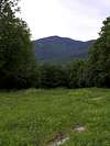
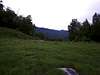
Snows Mountain is one of the smaller more humble mountains located within the White Mountains National Forest. It also has none of the amazing views some of the high peaks in the area have such as the Franconias or Presidentials . One thing it does have though is solitude and a few quaint litte landmarks that scatter its slopes.
The trails on this mountain don't even head up to the true summit, but they do take you to places such as Greeley Ledges, Elephant Rock, Fletcher's Cascade, and the Cascade Route. These smaller and less popular locations give this mountain its charm. You don't need to worry about finding more than a handful of other people on this mountain at any one time, even in peak hiking season.
As a member of the Waterville Valley Area mountains, Snows Mountain can still be quite rugged, as can any peak in the White Mountains. In winter time the west ridge of this mountain becomes littered with skiers as it has two ski slopes. The temperatures and winter conditions on this mountain can be quite harsh as they are in most parts of the White Mountains. Before any trip into these mountains you should know what you're up against.
Snows Mountain has a lot of attractions, but you have to find them first. In itself that is an attraction as you don't have the bustle and crowdedness as you do on some of the area's high peaks. This mountain also makes for a great evening hike after doing some of the higher peaks.
 |  |  |
Getting There
From Boston:
From Boston take Interstate 93 North for approximately 115 miles (about 2 hours) until you reach the exit for NH Highway 49 to Waterville Valley. Take this exit for 13 miles back into Waterville Valley until the road ends near the ski resort. You'll see signs for the trails which actually start up on the side of the mountain. The road will take you into a pretty "ritzy" housing developement where all the trails start in a pipeline cut.
Red Tape
There are no permits or fees required to hike on this mountain. There are also no parking passes required and there is room at the trailhead for about ten cars to park even though you'll never see that many. For conservation purposes follow the “LEAVE NO TRACE” program and you'll be fine. Just use common sense.
When To Climb
This mountain is climbable in all seasons of the year, but the best time would probably be in the fall because of the beauty of the foliage. Summer and Spring are also great times.
Winter is also an interesting time on this mountain. You'll actually find more people on this mountain during this time because of the ski slopes. Snows Mountain though would be a great mountain to do if you're into snowshoeing or cross-country skiing.
Camping
There is no camping on this mountain, but there are plenty of places in the area. On Tripoli Road there are tons of spots and that is just a short drive to the town of Waterville Valley.
Mountain Conditions
For current and up-to-date weather conditions click on the link below!
weather.com
dirth - Jul 11, 2007 12:41 pm - Hasn't voted
Mountain BikingYou may want to add something about mountain biking in the summer. I have been there a few times to both bike and hike. In the summer the chairlift runs and is used to transport people and bikes to the top so they can bike down. Also from what I have seen it does get fairly crowded in the summer just because of the touristy nature of Waterville Valley.