
|
|
Area/Range |
|---|---|
|
|
Scrambling, Skiing |
|
|
Spring, Summer, Fall, Winter |
|
|
4344 ft / 1324 m |
|
|
Overview
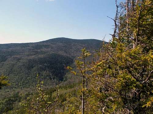
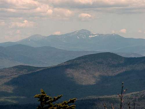
The Waterville Valley Region is well known resort region in the southern White Mountains. The resort is also home to a number of 4000 foot mountains in the region. The neighboring mountain range the Sandwich Mountain Range travels from Squam Lake to Mt. Chocorua. Among these mountains are Mt. Osceola, Mt. Tripyramid, Mt. Passaconnaway, Mt. Chocorua and Mt. Tecumseh. Though the area is most well known for it's skiing, hiking and climbing in the region is excellent. The best known of the routes is Mt. Tripyramid. The steep, rocky, YDS Class 2 North and South Slides make this peak one of the hardest non-technical routes in the White Mountains. Mt. Osceola's views are amongst the best in region feature a world class view of Mt. Washington. Mt. Chocorua is a class among hikers with it's treeless top (from fire) and stellar views.

Regional Definitions

The Waterville Valley Region travels from Welch and Dickey Mountain past the summit of Mount Tecumseh, over to the summits of West Osceola, Mt. Osceola and East Osceola and then to Mt. Kancaumaugus, Mt. Tripyramid in the eastern side to the Sandwich Mountain Range on the southern side and back to Campton. The mountain in this region vary in height from 2600 feet Mt. Welch to Mt. Osceola at 4344 feet. Though none of these mountains have timberline most of the mountains have great views either at the summit or close to the summit.
Getting There
To the town center of Waterville Valley: From I-93 get off onto Route 49 toward Waterville Valley. Stay on Route 49 past the town of Campton and up through the gap between Sandwich Mountain and Welch and Dickey Mountain. Continue up the road eleven miles to the trailhead which is on the right, just before the town of Waterville Valley.Red Tape
Most trails here require a White Mountain National Forest Parking Permit. As of 2005 these were $3 for the day. You can also purchase a parking permit off of Exit 28 in Campton, NH.Weather Conditions
Here is a link to a weather forecast for Higher Summits of the White Mountains .
Trail Conditions
Here are two websites that will provided you the best information on conditions in the White Mountains.Appalachian Mountain Club
Current Trail Conditions
Also drop by the Livermore Park Ranger station in Waterville Valley for more information.
Weather Conditions and Gear
Weather Conditions in this region vary widely throughout the year. There is a saying in New England that if "you don't like the weather wait a minute". Waterville Valley is not the exception to this. The weather is unpredictable at almost all times of the year. About the only thing you can depend on is that there not be snow in July and August and not be 100F temperatures in January and February. Though the mountains here are not as extreme as Mt. Washington, great care is need when climbing during the cooler months. Some of the mountains are 2500 feet from the floor of Waterville Valley and have drasticlly different weather than the town of Waterville Valley.

In summer this region is easy to dress for, especially if you taking one of the many dayhikes in the region. Only essential hiking gear is needed with sturdy shoes and a jacket. Bug repellent is a must in this region due to the spread of the deadly Triple E and the West Nile Viruses in the region. In very early summer it is also Black Fly season. Black Flys bite with a vengance and can leave scars on your body for weeks unless you used a strong bug repellent.

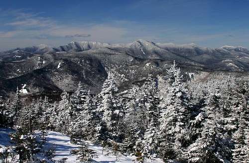
Winter in this region is the most unpredictable. Invest in crampons, snowshoes and yaktraks if planning on hiking in winter. Depending on the hike, you might end up using all three. At this time of year it is key to look at the weather forecast. An ice axe is highly recommended if you plan on climbing Mt. Tripyramid in the winter.I never usually hike in this region unless the weather is clear or partly cloudy. If a heavy snow has fallen recently wear snowshoes. If it cold and no snow has fallen for a while that wear crampons. You can't go wrong though if you bring both.

Fall is the pretty time but weather is highly unpredictable here. If you are staying overnight in the region bring everything except the crampons and the snowshoes. Though it doesn't start snowing in the reason until early October, the nights in this region can get cold even in September. Bugs become less of a problem after the first frost. Bring a sturdy jacket, gloves and a hat and keep your eye on the weather conditions during this time of year. Cameras in late September and early October are AN ABSOLUTE MUST. New England has some of pretty foliage in the United States if not the world.
Spring is the least desirable time to hike in this region. In April and May mud season from snow melt turns many of these trails to mud pits. Some trails are not even open at this time. However June can be a nice time to hike in this region. Temperatures are very reasonable and providing that you have bug repellent to avoid black flies you should have little problems with weather.