
-
 14494 Hits
-
 83.69% Score
-
 17 Votes
|
|
Mountain/Rock |
|---|---|
|
|
37.98580°N / 119.4805°W |
|
|
Hiking |
|
|
Summer, Fall |
|
|
10788 ft / 3288 m |
|
|
Overview
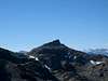
Pettit Peak isn't much more than a high point along an undistinguished ridge in Northern Yosemite, but what it lacks in aesthetic appeal and as a mountaineering objective is more than compensated for by both its views--some of the finest to be found anywhere in the park, with a commanding view of Sawtooth Ridge and much of the Yosemite high country--and its remoteness. The peak lies only a few air miles from Tioga Road, but it's separated from the crowds in Tuolumne Meadows by the vast Grand Canyon of the Tuolumne River, rendering it surprisingly inaccessible and making any approach a relatively involved effort. (Along with Volunteer Peak and Electra Peak, it's a strong contender for the title of most-difficult-to-reach peak in Yosemite). Those who seek out untrammeled summits will find some draw in Pettit's relative obscurity: Exactly a year had passed since the last sign in when I visited the peak.Pettit is an SPS listed peak, and those few people who make it up here (generally list seekers) almost invariably climb it in conjunction with Volunteer (also an SPS peak) via a class 2 traverse between the two peaks. It can also be climbed from Rodgers Lake (class 2 via an easy chute that leads up to the Regulation-Pettit saddle), or from Regulation Peak (also class 2).
 |  |
Getting There
Pettit Peak is almost always climbed via a traverse from Volunteer Peak; consult that page for directions to that peak. All of the commonly used approaches to Volunteer involve a 40+ mile and 10,000ft+ gain hike, round trip. The traverse itself involves about 1.5 miles of cross-country hiking, and should take no more than 1.5 hours (one way).In principle, a shorter approach to Pettit Peak is possible out of the south, although this involves considerable cross-country travel and is attempted very rarely. There was but one entry in the register mentioning such an approach over the last thirty years, specifically from Mattie Lake. (No details were given). The most feasible approach from this direction may be from Tuolumne Meadows via Return Creek. Follow the Glen Aulin/Pate Valley trail for ten miles to the bridge at Return Creek. Leave the trail here and follow the creek upstream for 1.5 miles past waterfalls, small pools, and over/between some enormous (living room-sized!) boulders until a brushy, talus slope can be climbed on the west side of the canyon. (The creek portion of the hike will likely take 2-3 hours). This slope leads to the easier, more open terrain north of Hooper Peak, where Register Creek can then be followed to Pettit Peak. This involves significantly less mileage and elevation gain than the alternative approaches to the peak, and is almost certainly the quickest option for a dayhike.
However, some caveats apply. This approach is best undertaken in the fall, when low water levels make it possible to follow the creek directly. Poor route-finding choices will lead to some seemingly endless boulders and awful bushwhacking (and if this doesn't sound fun enough, the author also disturbed a wasps' nest and received some half dozen stings while conducting a reconnaissance in this drainage). It is the author's opinion that this is a tedious approach that has no merit as a backpacking approach and little merit even as a dayhiking approach. For the sake of fairness, I'll mention that Bob Burd disagrees with my assessment, and feels this is still the preferable approach to Pettit for a dayhike. You'll have to decide for yourself whose opinion you trust more. :-)
If considering the Return Creek option, it may be worth pointing out that Voge's 1954 edition of the Climber's Guide to the High Sierra comments that "The traveler who inspects the map and can imagine no reason for the lack of a direct trail connection between Waterwheel Falls and Matterhorn Canyon can quickly if not easily find the reason for the longer route followed by the trail."
Red Tape, Camping, Conditions, etc.
See the Volunteer Peak page for details.Etymology
"Named by Col. W. W. Forsyth, acting superintendent of Yosemite National Park, 1909-12 for Col. James Sumner Pettit, commander of the US Fourth Volunteer Infantry in the Spanish-American War. (Farquhar: Forsyth.)"- Peter Browning, Place Names of the Sierra Nevada