
-
 12811 Hits
-
 86.85% Score
-
 23 Votes
|
|
Mountain/Rock |
|---|---|
|
|
42.57530°N / 19.55760°E |
|
|
7165 ft / 2184 m |
|
|
Geographical Structure
Dinaric Alps 4 Central Belt 4 Površi i brda (Highlands and mountains) area of Montenegro 4 Kučka krajina mountains 4 Central Cluster 4 SurdupOverview
PositionThe name Surdup stands both for the mountain as well as for its highest summit reaching 2,184 m. The mountain is situated in Montenegro´s Kucka krajina mountains, north-east of its capital Podgorica.
Also, Surdup is centrally located in the in Kucka krajina mountains, extending accros the most of the area of Central cluster of this subgroup.
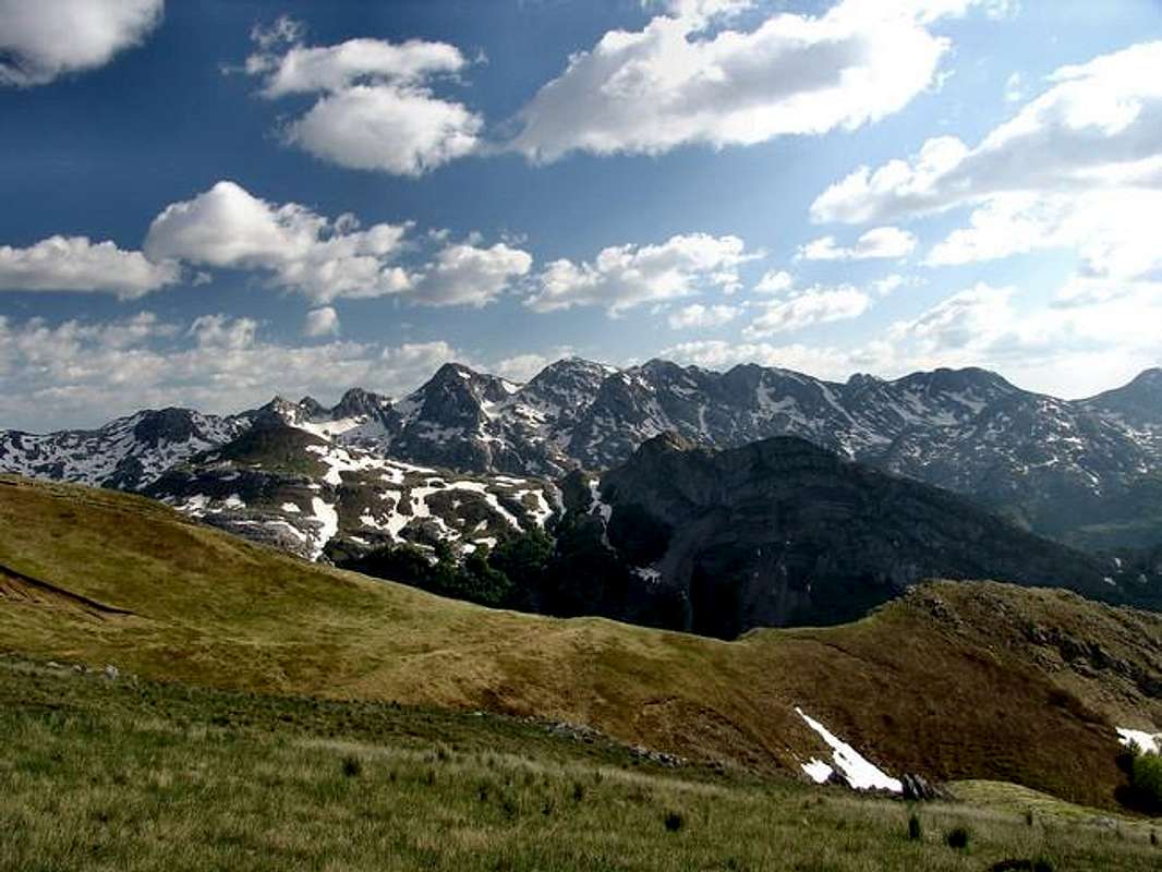
Surdup and the Central Cluster of Kucka krajina mountains, seen from north, from Maglic (Kucki). Surdup´s main summit (Surdup 2,184 m) is the one in the center of this photo and Surdup´s mountain ridge stretches to the right of the main summit. The saddle on the right side of this ridge is Cafa of Treskavca mountain pass that separates Surdup from Treskavac mountain (2,024 m). The high summit just left of Surdup is Stitan (2,165 m) connected to Surdup with a mountain pass
The first neighbors among the mountains and summits of Kucka krajina, that encircle Surdup are: Treskavac (from Surdup´s west; 2,024 m), Velji vrh (from NW; 1,916 m), Torac (read c as ch in much) (from north; 1,842 m) Pasjak (from NE; 2,051 m), Stitan (read s as sh in shower) (from E; 2,165 m), Smojan (from SE; 2,080 m) and Sila (read s as sh) (from SW; 2,129 m).
Surdup mountain rises from a high plateau that is situated between Bukumirsko jezero (jezero=lake) and katun Jezero, then Trepetljikov do a deep valley on its SW side, and katun Rupa Beljeva close to Kostica (read s as sh) valley, on its SE. The other mountains and summits that rise from the same plateau are: Treskavac and Velji vrh - west of Surdup, and Pasjak and Stitan - which both make an eastern continuations to the main mountain ridge of Surdup.
Thanks to glacial influences and later karstic processes, the relief of abovementioned plateau, together with all the mountains of the Central cluster rising from it (and Surdup especcially), shows well-indented plasticity and many different forms.
Because of such relief complexity present accross the Central cluster, the limits of Surdup mountain are not determined by its morphology only, but also by other factors, especially the local tradition. Therefore the summits of Stitan, Pasjak and Treskavac are considered to be separate summits although they are connected to Surdup´s main ridges almost directly.
Roughly, the limits of Surdup mountain (starting from W, clockwise) include: katun Guzovalja (1,650 m) > Mojan plateau > Cafa od Treskavca a pass next to Jezerce plateau at 1,867 m (with a small Guzovalja (or Jezerce) lake) > Skala od Jezera pass (at 1,885 m it separates Surdup area from that of Treskavac mountain) and Rupa Jezerca (a deep karstic field) > Velji vrh (summit, 1,916 m) > katun Jezera around Bukumirsko lake > Konjski do (a field SE of katun Jezero) > Stirni do (a field at 1,650 m between Torac, Pasjak, Surdup and Bigeze) > Pasjak (summit 2,051 m) > a circular field Sarajevo > another pass at 2,050 m (that separates Surdup from Stitan summit) > Cafa od Poda (a pass at 1,950 m, situated between summits of Surdup, Stitan and Smojan) > Velji do (a field) > katun Gladista (former katun, now abandoned) > Rupa jablanova (deep field, almost a gorge) > back to katun Guzovalja.
The name
According to the folk tradition surdup means a chasm/ravine.
The name Surdup is the older one, and of Vlach origin, although the most of today´s population in the area is Slavic and Albanian. But many other toponyms and names in the area (f.e. Bukumir-lake, Bulatovic-family name, can resemble you to the name of Bucurest, Romania) also show the influence of Vlachs, the old „shepherds and mountain farmers nomadic folk“ of classical Romanian origin that was more present here and in the rest of the Balkans in the older times, but whose blood is still mixed with today predominantly Slavic-Albanian population of Kucka krajina region. But thanks again to Vlachs´ influences the term Surdup can be found on many other mountain locations in Kucka krajina, as well throughout SE Europe (f.e. Surdup in Lukavica mountain in Montenegro, Surdup area on Dinara, mountain in Croatia, and Surdup in Bosnia&Herzegovina; also szurduk means a chasm in Hungarian language, too).
In addition to previously mentioned Vlachs´ influences, it is worth mentioning that many of other toponyms on Surdup, as well as in Kucka krajina region, have unusual combination of Slavic and Albanian words. For example Cafa od Treskavca (means Treskavac´s pass) is made of Albanian word for a pass which is „cafa“ (read c as tch) and of he term „od Treskavca“ which is a Slavic grammar genitive meaning „of Treskavac“/„belonging to Treskavac“.
Today, in science and geography, the term surdup stands for a carstic surface formation - an infrequent one. Surdup is according to that definition a tight and very deep flute with vertical walls (rarely with inclined ones). It has been developed thanks to combined influences of limestone-crack-systems and huge amounts of water present in post-glacial periods.
The ridge
The physionomy of Surdup is mostly characterised by a main 2 km long ridge that stretches in NW-SE direction. The highest part of the ridge rises from average height of 1,800 m just SE of Cafa of Treskavca and Jezerca plateau and stretches all the way to the highest summit Surdup, at the south-east end of the mountain. This ridge is the highest part of the mountain with crests of summits that are mosltly higher than 2,000 m (2,104 m, 2,089 m, 2,052 m, 2,051 m etc.) The ridge is treeless and rocky, narrow and steep on many places. A walk along the ridge is a great experience, but deserves a full caution!
One branch off the main ridge begins at central part of Surdup and stretches southern of the main ridge in SW direction untill it finishes as steep rocks above katun Gladista.
Another indentet mountain ridge branch off the main ridge just north of the main summit in direction of Bukumirsko lake and Torac mountain. It ends 1,5 km to the north in a form of steep and towering rocks just above Konjski do and katun Jezera valleys.
All the branches of Surdup are characterised by steep slopes, rocky towers, glacial gorges full of karst material, deep ravines, sink holes and many disintegrated rocks, especially above the fields Konjski do, Rupa jablanova gorge (near Trepetljikov do) and field Sarajevo.
  |
The summit (2,184 m)
The main summit of Surdup is a rounded plateau full of scattered rocks and covered with low turfs of grass. The summits surface has received many thunderstrucks and the proof for this can be easily found all around the summit in a form of a looosely rocks and crushed stones.
When looking from the South, the summit of Surdup looks like a symmetrical dome, but whose harmony is disrupted with a huge cut on its southern front. The western slope of the summit is covered with huge limestone plates, full of fractured rocky slabs and turfs of grass. Probably the most dramatic part of the summit is its northeastern side dominated by vertical rocks that rise above Sarajevo field (a circular karstic area, a depression between summits of Pasjak, Stitan and Surdup). A huge mass of snow remains here almost every year until july/august, all the way up to the pass between Stitan and surdup.
The best approaches to the summit are from SE and NW sides over surrounding ridges and mountain passes.
From NW you approach the summit by a ridge, with grassy slopes and vast areas of limestone - covered with many shallow flutes, step-like (but steep) formations, and smaller heaps of eroded rocky materials (tochila).
Another (and the most used) approach to the summit is from its SE and eastern side, from a mountain pass that separates it from nearby summit Stitan.
Views
The central position of Surdup and the lack of trees and bushes - not only of the summit, but also most other peaks on Surdup mountain - make them great sightseeing points. From the summits of Surdup you can see and feel the might and influence former glaciers had on the morphology of surrounding mountains and the whole region – plateaus, carstic valleys, rigdes and crests, towers, etc.
From the main summit - starting from north, clockwise - one can observe the area around nearby Bukumirsko lake > Maglic (Kucki) mountain (2,142 m)> Komovi, mountain (2,487 m)> Planinica mountain and row of border mountains (between Montenegro and Albania), all the way to Visitor mountain > Plav-Gusinje-Vermosh valley and mountains of eastern part of Prokletije (Cakor, etc.) > central and southern parts of Prokletije range (Vezirova brda, Belic, Krosnja, Karanfili, Maja Jezerce) > all other sections of Kucka krajina mountains group (its central, eastern, and southern parts) > and finally to the west, the mountains of Central Montenegro around Moraca river (Moracke planine=Moracke mountains; read c as ch) can be seen.
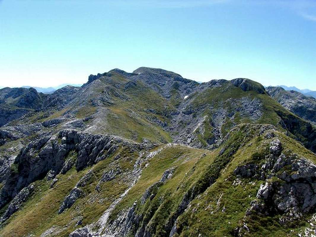
The summit of Surdup (2,184 m) seen from NW, from its main mountain ridge
Routes Overview
After you solve the problem of coming to the region of Kucka krajina (see Getting there section) you should consider and choose some of the approaches to Surdup mountain from its foot. But be aware that the most of the approaches are not marked or marks have already faded. The approaches to Surdup last from 2-6 hours, depending on the trail and beginning point you choose.
The best and the most usual starting points to climb Surdup are shepherds´ summer settlements (katuns), situated mostly at the foot of the mountain, on its northern (katun Jezero, katun Momonjevo), suthwestern (katun Guzovalja) and southern side (katun Rupa Beljeva).
1. The classical approach Bukumirsko jezero - Surdup (marked trail)
Starting from Bukumirsko lake and katun Jezero you can use this marked trail (probably the most used one for the Surdup ascent). The trail passes through rocky gorges and across small mountain fields, just under the slopes of Torac, Pasjak, Bigeze and Stitan mountains (summits), so there are plenty of additional targets you might consider. It takes you 3 to 4 hours of climb in one direction.
2. The southwestern approach Guzovalja - Gladista – Cafa of Poda – Surdup (partially marked trail)
This trail starts from katun Guzovalja, and passes just south of Surdup´s main ridge, along all of its length, in about 3 hours. The trail passes over smaller or larger fields (some of them with remains of former periodical shepherds´ settlements, like katun Gladista) and through rocky gorges untill it reaches Cafa od Poda mountain pass, with a suitable position for Surdup summit climb.
3.The Ridge trail Cafa od Treskavca to Surdup along the mountain ridge (non-marked trail)
There are two possible ways to reach Cafa od Treskavca pass, one by a 30 min. climb from katun Guzovalja and the other from katun Momonjevo (and further from katun Jezera near Bukumirsko lake, or katun Bljustura on the local road Podgorica-Kastrat-Mokro). Walking this trail is amazing experience, both visual as well as creative and the adrenaline-full one.
4. The Southern approach katun Rupa Beljeva – Cafa od Poda - Surdup
You canreach Surdup via katun Rupa Beljeva, which is situated SE of it. To get to katun Rupa Beljeva you can chose a trail from katun Korita (much further to the south, this is and old and traditional trade and shepherds´ route), or katun Rikavac (west of it, close to border with Albania). Most of these approaches are more than a half day effort (in one direction), especcially in case you want to avoid any 4-wheel drives.
For better orientation you can also refer to maps put on Kucka krajina mountains subgroup SP page.
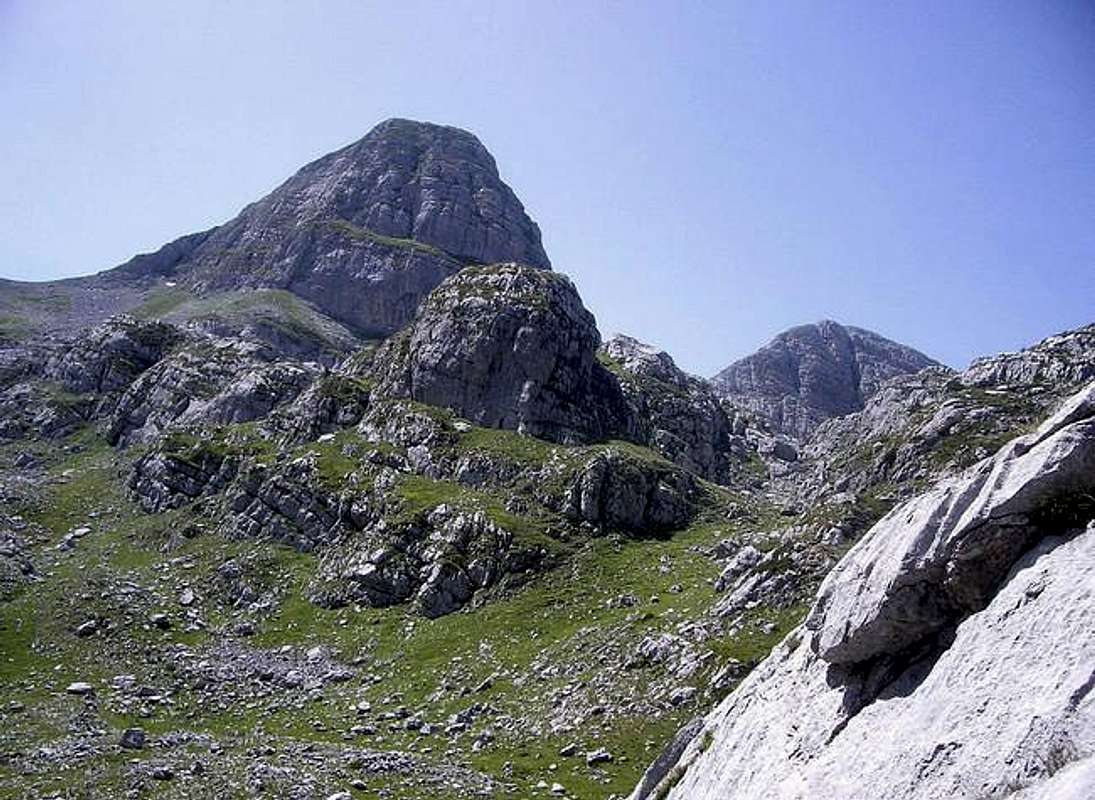
The first glimpse of mighty Surdup (in the background) when taking the classical approach route from Bukumirsko lake. The summit on the left side of photo is Stitan (2,165 m). The photo is taken from the place where the trail leves Rupa velja field (or Mijicev do) and heads toward Jezerca, a small pass and a plateau (1,880 m) situated between summits of Surdup, Pasjak and Stitan
Other Features
The mountain is almost completely treeless. You can find some woods only around its foot an on two location only - in the area around katun Guzovalja and SE of katun Jezero. The rest of surface of Surdup is covered with grass or is just rocky. This will make you easy to orientate, especially when you hike the mountain ridges of Surdup.
Because of abundance of grassy meadows around, and on it, Surdup used to be very popular among shepherds and it was used for some centuries by brotherhoods (and families) of Kuchi clan who came here to live, over summer, with their livestock. Kuchi also allowed the shepherds from coastal Montenegro to use their pastures during summer time. Kuci clan is one of the oldest Montenegrin clan, that populates highland and mountain areas NE od Pogorica, the capital of Montenegro, east of the Montenegrin-Albanian frontier. It is interesting that the member of this clan originate from both Slavic as well as of Albanian origin.
Around Surdup you can still find clusters of shepherds huts (stan, singular) positioned close to pastures. Such cluster is called katun. Some of those katuns are stil lively (from June to September), but like a situation in the rest of Dinaric Alps and Prokletije, depopulation is also present here - some of katuns are being abandoned (katun Gladista) and some of them are being transformed into weekend-houses settlements.
 |  |  |  |  |
Getting There
For surdup ascents the best way to get close to starting points is by car. There are some bus connections from Podgorica, but only to get to the outskirts of Kucka krajina mountain Group, and then, to reach the foot of Surdup mountain you could continue by foot only or pick up transport from locals. No other kind of public transport does exist in the vicinity of Surdup.To get close to the wider area by plane
The most appropriate way to arrive by plane is to Podgorica airport. The airport stil has no web-site so try to get info on the sites of two biggest airline companies that operate to and from Podgorica:
Montenegro Airlines
JAT – Yugoslav Airlines
Belgrade Airport - for flights between Podgorica and Belgrade and between Tivat and Belgrade.
There are also other possibilities to arrive by plane but it will take you more time to travel from there to Kucka krajina. They are Tivat Airport (Montenegro) and Dubrovnik Airport (Croatia).
To get close to the area by bus
The closest you can get by bus is to Verusa (to approach Surdup from north, via Bukumursko lake) and to Orahovo - via Ubli (to approach Surdup from south, via katun Korita, or from west via Stravca/Krzanje).
Bus connection from Podgorica to Verusa (via Lijeva Rijeka): 2 times a day at 07:00 and 14:20 h, maintained by "Minic - prjevoznicko preduzece" (read: Minitch) transport company, every day MON-SUN. Departure: Podgorica main Bus Station. Info at: ++381 81 621 923 (you are much in advantage if you understand local language).
Bus connection from Podgorica to Ubli and Orahovo 4-5 time a day (starting from=7:00, 10:30, 13:15, ..), maintained by "Minic" transport company, every day MON-SUN. Departure: Podgorica main Bus Station.
There are no bus connections to the area from/to Kolasin.
To approach the foot of Surdup mountain by car/bike or similar transport you can use next roads:
1. Podgorica – Bioce (read: Bioche) – Lijeva Rijeka – Verusa (Verusha), to get to Bukumirsko lake and katun Korita - for northern Surdup approaches.
2. Kolasin (Kolashin) or Andrijevica – Matesevo (Mateshevo) – Verusa - to get to Bukuumirsko lake and katun Korita - for northern Surdup approaches.
3. Podgorica – Ubli – Krzanja – Gornje Stravce – to approach Surdup from west via katun Guzovalja, or northern approach via Bukumirsko lake.
4. Podgorica - Ubli – Orahovo – Radeca (r: Radetcha) – to approach Surdup from south via katun Korita and katun Rupa Beljeva.
To approach the Group and summits by train
Very attractive Belgrade-Bar railway passes by western outskirts of Kucka krajina mountain group. There are more stations close to Kucka krajina, but except Podgorica you will have problem to find convenient public transport from those stations to Surdup. All stations have 3-4 trains a day in each direction (north or south) and Podgorica and Kolasin even more, 6-9 per day.
The stationst to choose are: Podgorica, Bioce, Seliste, Matesevo.
Best information on train schedules at:
Serbian Railways-homepage (search under „Passenger Traffic“, then „Train Sequence table – Stations Timetable, then choose your stations).
Serbian Railways-direct access to Station Timetable.
 |  |  |  |  |
Red Tape
Because of the vicinity of border with Albania, have your IDs with you. Recenty, Montenegrin police has taken over border posts in the area from the military, but they left some of previous borde-posts vacant, so if you visit the area these days you will not be able to see as many border patrols as you could do it before. It is also worth the effort if you visit a local police station before your trip to border areas and to report your future plans - especially if they are more comprehensive.The danger you must count on, is the fact that the mountain receives lots of precipitation throughout the year, it is treeless and therefore very exposed to atmospheric influences (winds, snow, and especcially thunderstorms). The ground is not solid on many locations and take care of crumbling rocks and theirs´ disintegration. Also, always take enough water with you!
When To Climb
June to September are the best months to climb Surdup, because of nice weather and the presence of shepherds in nearby katuns. June and July are excellent months to visit the mountain because of strong green color of young grass over the pastures and better quality of the air - for nice views.Other periods of year can be nice too. Despite the high altitude the Region lays close to the “mediteranean Sun” and mediteranean influence mix here with the continental one, thus giving lots of precipitation throughout a year, but sometimes easing sharpness of a mountain climate. Daily summer hikes can be hot – don’t forget the mountain is almost completely treeless. Shades and shelters from sun, wind and rain are scarce.
The mountain is nice in winter too. But be aware of many chasms, crumbling rocks and avalanches.
 |  |  |  |
Camping
Like for the rest of Kucka krajina mountains GROUP, there are no mountain houses/huts or bivouacs in the area, also no camping places. Even in wider area you will not be able to find such objects at convenient distance.By state laws (like everywhere else in the world!) the camping is not allowed outside camping areas mostly because some would avoid to pay for prenotation, but this area is so remote and touristically undeveloped that many laws simply have no sense here. So hikers very often put up their tents by lakes in the area or close to the huts. There are no special rules on camping. No one can stop you from puting it up, especcially when you have no alternative to find another accomodation before night. But even if you camp on that "wild" way, BEHAVE ECO-CONSCIOUSLY!
In case you need a shelter on Surdup many times you will even have a problem to find appropriate place which is secure enough (from thundestrucks, wind), or even flat enough (!) to put up a tent. Sometimes, the most you can do is to hide under some of the cliffs, rocks or wholes.
Like for the most of mountains in the area, here too you can try to ask local shepherds for a sleeping place in their huts in nearby katuns. They are modest people, they will never try to profit from you, not even ask money from you, so don’t take advantage of them. An offer to pay for accommodation, even to give some sweets to their children would be very nice and I strongly recommend it to you. And especially from June to early September, there will always be some people on many of those katuns.
Katuns in the area around Surdup, where you can still find some people in summer period are: katun Momonjevo (1,772 m), katun Guzovalja (1,650 m), katun Jezera (by the Bukumirsko lake 1,443 m). Other less populated or even desolated katuns are Rupa Beljeva (SE od Surdup) and Gladista (SW of Surdup, no shepherds´ huts exist any more, just remains of them).
Other accommodation possibilities (if you plan a day hikes) are in Podgorica or Kolasin area, and Podgorica is much better choice because of larger number of hotels/motels, while accomodation in Kolasin is less expencive.
 |  |  |  |  |
Mountain Conditions
As the most important warning: be very much aware od the danger of thunderstruks and snow blizzards!! All of Prokletije and surrounding areas are well known for it!Nearest weather stations to the mountain are Kolasin, Podgorica and Medjurijecje (in Moraca valley). Since Podgorica is in Zeta river valley it is very much open to Mediteranen influences and the weather in Podgorica is many times better and much milder than on Surdup. So Kolasin´s and Medjurjecje´s weather reports and forecasts can be more usefull to you.
Weather information at:
Kolasin at Accuweather
Kolasin at MultiMap-5 days Forecast
Pogorica at Accuweather
Medjurijecje at Accuweather
Other local weather info (sorry they don´t have English pages) at:
Meteo-CG.
There are no live web-cams in the area to look at live weather situation
Surdup (dominant in the background in central part of the photo), seen from katun Jezero, close to Bukumirsko lake. Left of Surdup stands Pasjak peak (2,051 m) and right from it is Velji vrh (1,916 m)

 |  |  |  |  |
Distances
Katun Jezera (Bukumirsko lake) - Surdup: 3 h of walkKatun Guzovalje - Cafa od Treskavca (mountain pass) - Surdup main ridge - the summit of Surdup: 2 h 30 min – 4 hours of walk (this is Surdup ridge trail)
Guzovalje - former katun Gladišta - Cafa od Poda - Surdup: 2 h 30 min of walk.
Maps
Practical map of Surdup area and the most common approaches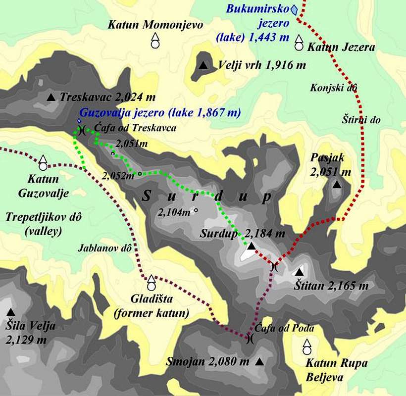
 |