
|
|
Mountain/Rock |
|---|---|
|
|
45.98834°N / 13.63412°E |
|
|
Mountaineering |
|
|
Winter |
|
|
1998 ft / 609 m |
|
|
Overview

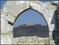
Sabotin has outstanding position, natural sights and turbulent history. So Sabotin is a mountain worth a visit.
It is a mountain with great variety of vegetation, since “three great European floristic areas” – the submediterranean, dinaric and prealpine – come together here. As regards fauna, Sabotin provides an important habitat and migration corridor for some rare bird species. The area of Sabotin has the status of natural value of national significance; it has also been designated as ecologically important area and included in the Natura 2000 network.
Getting There

Mountain is on west (more south-west) part in Slovenia (south-east part of Italy). The largest near cities are Gorizia on Italian side and Nova Gorica on Slovenian side. Sabotin is the most south mountain in prealpine area of Julian Alps.
Red Tape


Is no limitation
Camping

1. Dom na Sabotinu (ex-military boarding position)
2. Hotel Sabotin in Solkan
Routes Overview


Slovenian side:
Northern Trail: Solkan, parking lot before the bridge river Soca (Isonzo) in Solkan, over east-north side (1,5h)
Southern Trail: Solkan, parking lot before the bridge river Soca (Isonzo) in Solkan, over the south side (1,5h)
Corridor Trail: the road from Sokkan in Brda (corridor for road from Slovenian town Solkan to Slovenian part Goriska Brda goes over Italian part), right behind the Italian corridor (1,25h)
Podsabotin Trail: bus stop in Podabotin (1,25h)
Briska Trail: the road from Gonjace to Plave, touring of a macadam road to Sabotin (2h)
Italian side:
Smaver Trail: Smaver/Sna Mauro at the cemetery (1,5h)
External Links

Hotel Sabotin
Miscellaneous Info

On north side of Sabotin can You see also the system of Austro-Hungarian caverns (below the ridge of Sabotin). The Austro-Hungarian army began fortifying caverns on Sabotin in 1915, and defended the position until August of 1916, when Sabotin was taken by the Italians in the sixth Isonzo battle. The interior of the caverns was panelled with wood, and wooden barracks were ercted in frontof their entrances. Food and ammunition were transported up Sabotin from the Isonzo valley cia a cableway.
Some rest of war is now in a small museum on “Dom na Sabotinu”.